Bears Ears: Cedar Mesa Day-Drive Stops and Respectful Ruin Viewing
Cedar Mesa is one of the most quietly powerful places in the Four Corners. It is not a theme park. It is a living cultural landscape layered with canyons, pinyon and juniper, big-sky overlooks, and thousands of archaeological sites connected to the ancestors of today’s Puebloan peoples. The best day here feels simple: a few legal, established corridors and routes, a couple short walks to views, a lot of restraint, and a commitment to leaving everything exactly as you found it.
This guide focuses on day-drive stops that keep you on established routes and respectful ruin viewing that does not turn sacred places into props. If you want to go deeper into the canyons, I also call out what belongs in a backpacking plan instead of a rushed day trip.

Before you go: boundaries and closures
Bears Ears National Monument includes a huge swath of public land in southeastern Utah. Many Cedar Mesa highlights sit on or near a network of dirt roads and short trails. That convenience is exactly why staying on designated routes is so important.
One reality to plan around: monument boundaries, access rules, and seasonal closures can shift over time due to management updates, restoration work, and weather. Check current status before you drive, not after you arrive.
Know who manages what
- Recreation access is managed primarily by the Bureau of Land Management (BLM) across much of Cedar Mesa, including many trailheads, primitive roads, and camping rules.
- Some monument lands and nearby routes are managed by the U.S. Forest Service (USFS). Depending on where you are, travel rules may be guided by USFS maps and motor vehicle designations.
- Some areas and access points involve Utah State Trust Lands or private inholdings. Those may require permission or have different rules.
- Tribal connections are not “historical footnotes” here. Many sites are culturally sensitive today.
Closures are not optional
If a trail, spur road, or site is signed as closed, do not enter. Closures can be for cultural protection, erosion, seasonal hazards, or active restoration. Going around a sign creates new social trails and accelerates damage that cannot be repaired.
Best habit: check current conditions and closures before you drive. The BLM Monticello Field Office, USFS offices for nearby districts, and official monument updates are the right sources. In spring and after storms, road conditions can change overnight.
What “designated routes” means
- On roads: stay on signed, existing road surfaces. If a two-track becomes mud, do not drive around it and widen the route. Turn back.
- On foot: use established trail tread, rock, slickrock, washes, and other durable surfaces where travel is clearly concentrated.
- At viewpoints: keep wandering tight around hardened pullouts and obvious use areas, instead of fanning out across cryptobiotic soil.
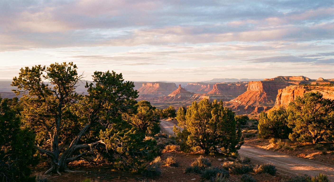
Drive corridors for a day
For a compact plan, think in corridors rather than checklists. Cedar Mesa rewards slow travel: fewer stops, more time at each, and a stronger chance you will be the only car at an overlook.
UT-95: the scenic spine
Highway 95 is the easiest, most reliable way to stitch a day together. It is paved, beautiful, and gives you access to major viewpoints with minimal route-finding stress. Use it as your backbone if you are short on time or driving a low-clearance vehicle.
UT-261 and the Moki Dugway area
UT-261 climbs onto Cedar Mesa with dramatic overlooks. The famous switchbacks of the Moki Dugway are graded dirt and can feel intimidating if you hate exposure. If weather is wet or icy, do not force it. Winter ice and shoulder-season mud can turn an easy-looking drive into a bad decision quickly.
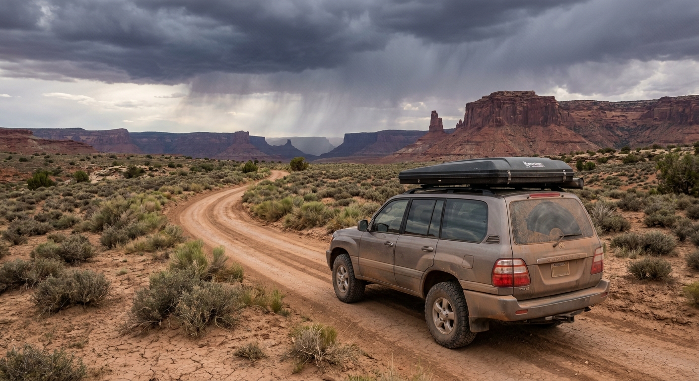
Cedar Mesa backroads
Many signed routes on the mesa are dirt and can turn slick, rutted, or impassable when wet. If you do use them:
- Drive only on existing roads. Do not widen, go around mud, or create new tracks.
- Bring a full spare, a jack that works on uneven ground, and more water than you think you need.
- Expect no service. Download offline maps and tell someone your route.
Day-drive stops
Below are stops that fit a day plan because they are either roadside or short walks to viewpoints. Some include distant views of cultural sites. Distance is part of the protection. It keeps fragile places intact.
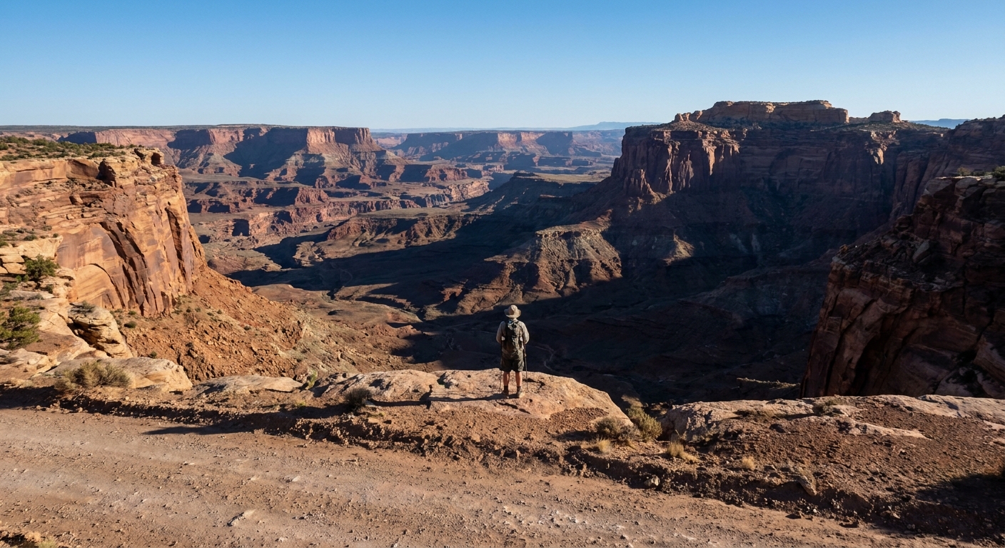
Muley Point overlook
If you want one “wow” stop with minimal hiking, Muley Point delivers. You are on the edge of Cedar Mesa looking out over a maze of canyons and monoliths. The wind can be fierce, and the cliff edge is real. Keep kids close, keep tripods anchored, and give the rim plenty of space.
Valley of the Gods scenic drive
This iconic loop threads between sandstone towers and wide-open desert. It is usually passable in dry conditions for many vehicles, but after rain it can become slick, rutted, and impassable. Even when dry, conditions can vary and some sections can be rough. If it looks wet, skip it. The most respectful choice is often the boring one.
- Stay on the established road. Do not pull off onto crusted soil or cryptobiotic ground.
- Keep speeds low. Dust impacts plants and other visitors, and it lingers.
Comb Ridge viewpoints
Comb Ridge is a long, dramatic geologic fold with layers of rock that look like the spine of a sleeping creature. Even if you never leave the pullout, you get a sense of the scale that shaped travel routes for thousands of years. Choose a safe, legal pullout and keep your walk within hardened surfaces.
Newspaper Rock
Outside Bears Ears National Monument, but close enough that many people pair it with Cedar Mesa. It is also an excellent place to practice “look, do not touch” around rock imagery. Oils from fingers and the abrasion of sand can permanently damage panels.
If you are building a day, consider it a short stop on the way in or out rather than another canyon mission.
Respectful ruin viewing
In Cedar Mesa, the most important gear is not your camera or your boots. It is your judgment. Ancient structures and artifacts are extremely vulnerable, and even small impacts add up fast.
Distance protects
- View sites from established trails and overlooks.
- Do not climb walls, enter rooms, or step onto masonry. Even “just for a second” can destabilize stonework.
- If you encounter an unmarked site, treat it as sensitive. Back away and do not share exact coordinates publicly.
Nothing gets moved
Please do not:
- Pick up pottery sherds, stone flakes, corn cobs, or any artifact.
- Rearrange rocks or build cairns near sites.
- Brush sand off walls, sweep floors, or “tidy” anything for a better photo.
Leave everything exactly as it is. Taking artifacts is illegal on public lands, and “small souvenirs” erase the story for everyone after you.
Sound and presence matter
These places often feel quiet in a way that changes your voice automatically. Follow that instinct. Keep groups small, lower your volume, and step aside if others are experiencing a site in silence.
Photography ethics
I love a good ruin photo as much as anyone, but Cedar Mesa is where I practice taking fewer images and earning the ones I do take.
Stand on durable surfaces
- Do not step onto cryptobiotic soil to “clean up the foreground.” That living crust prevents erosion and takes decades to recover.
- Avoid trampling vegetation near walls and alcoves. Foot traffic widens social trails fast.
Skip precise location hints
Even well-meaning posts can increase visitation to fragile sites and invite vandalism. Consider turning off precise location data and keeping captions general, for example “Cedar Mesa” instead of a trail name or mile marker.
No posing on structures
Do not sit on walls, lean on rock art surfaces, or stage shots inside rooms. If a photo requires you to touch, climb, or enter, it is not worth taking.
Leave No Trace basics
Standard Leave No Trace guidance applies everywhere, but Cedar Mesa adds cultural and archaeological layers that deserve extra care.
Travel and camp on durable surfaces
- Use established trails and roads.
- Do not drive around obstacles or mud. Turn back if needed.
- Camp only in existing sites where allowed. Dispersed camping rules vary by area, and camping too close to cultural sites can cause damage.
Pack out everything
- All trash, all food scraps, all micro-trash like bottle caps and fruit stickers.
- If you see litter near a pullout, grab a few pieces. It makes a real difference in remote areas.
Human waste
Desert soils break down waste slowly, and toilet paper becomes permanent “flagging.” In many high-use areas, a pack-out system is the most responsible choice. Where burial is allowed, follow local guidance carefully and stay far from water sources, trails, and cultural features.
Fires
Use established rings only where fires are allowed, and know current restrictions. Deadwood is habitat in the desert, and fire scars linger for years. Do not build new fire rings.
Day trip vs backpacking
Cedar Mesa is full of routes that look “short” on a map, until you factor in slow dirt roads, deep sand, navigation, and the way you will stop every two minutes because the light keeps changing.
Good for a day-drive
- Paved and graded corridors (UT-95, UT-261 in good conditions)
- One scenic dirt loop if dry and you have time margin
- Overlooks and short walks where you can turn back easily
Better as a backpacking trip
- Deep canyon routes that require route-finding, water planning, and a turnaround buffer
- Long approaches on sandy roads where getting stuck turns into a multi-hour problem
- Any plan that involves visiting multiple fragile sites in one day
If you are tempted to cram in “just one more canyon,” that is usually your signal to save it for a dedicated trip when you can move slowly and respectfully.
A compact day itinerary
This framework works well from Mexican Hat, Bluff, or Blanding, depending on where you sleep. Adjust for weather and road conditions.
Option A: Big views, minimal dirt
- Morning: Drive UT-261 toward the mesa, stop at safe viewpoints
- Midday: Muley Point overlook, picnic lunch with pack-out
- Afternoon: Return via paved routes, add a short roadside geology stop on UT-95
- Sunset: A final pullout view, then dinner in town
Option B: Add a scenic dirt loop if dry
- Morning: Valley of the Gods loop at low speed
- Midday: Muley Point or a rim overlook, stay well back from edges
- Afternoon: Comb Ridge roadside viewpoints on the drive out
Time cushion: build at least 2 hours of margin for slow driving, unexpected road issues, and the simple fact that you will want to sit and stare.
Safety and logistics
Road reality
- After rain or snow, dirt roads can become impassable. Turn around early, not late.
- Carry extra water, especially in warm months. You will use it even if you never hike.
- Fuel up in town. Services are sparse.
Weather and exposure
- Wind on the mesa can be intense, even on clear-sky days.
- Sun is strong year-round. Bring layers, sun protection, and more water than you think.
- Summer heat and monsoon storms can be a dangerous combination. Plan earlier starts, watch the sky, and avoid committing to long dirt-road spurs when storms build.
Permits and current rules
Some trailheads, camping areas, and special-use zones in the broader region can involve permits, fees, or specific restrictions. Rules can vary by managing agency and location. Confirm requirements before you go through official BLM and USFS sources.
Navigation
Download offline maps and carry a paper backup. For motorized travel, official BLM travel maps and USFS MVUMs, where applicable, help you stay on legal routes without guessing.
Accessibility
Many highlights in this guide are roadside overlooks or short, uneven walks on natural surfaces. If you need step-free access, focus on paved corridors and viewpoints from established pullouts, and call local offices for the most current accessibility details.
Quick checklist
- Stay on designated routes and obey closures.
- Look from a distance. Do not enter, climb, or touch masonry.
- Do not touch rock art or any marked surfaces.
- Leave artifacts where they lie, always.
- Skip geotagging precise locations.
- Pack out all trash, including micro-trash and toilet paper.
Cedar Mesa will still be here tomorrow. The goal is to make sure the fragile parts of it still look and feel intact for the people whose history is written into these canyons, and for travelers who have not arrived yet.