Bell Rock Pathway and Courthouse Butte Loop
Maya Lin
Maya Lin is a travel journalist and outdoor enthusiast who believes the best trips combine rugged adventures with urban comforts. After spending six years backpacking across four continents, she founded Trail & Town Guide to help fellow travelers navigate both hidden mountain passes and bustling city neighborhoods with confidence.
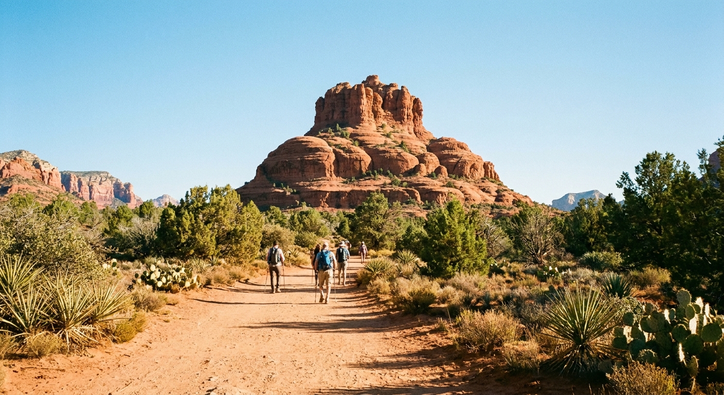
Bell Rock is the Sedona hike I send to friends who want that iconic red rock backdrop without the Devil’s Bridge bottleneck and the parking drama that often comes with it at peak times. The Bell Rock Pathway and the Courthouse Butte Loop deliver big views, wide tread, and lots of choose-your-own-adventure mileage. You can keep it mellow on the flat pathway, or tack on short spur climbs when you feel brave.
Below is a trail-specific breakdown I wish someone handed me the first time: where to park (and what pass you actually need), clockwise versus counterclockwise routing, where the trail bakes or gets slick, and a realistic two-hour plan that feels like “Sedona greatest hits” without the crowds.
Quick facts
- Trail: Bell Rock Pathway + Courthouse Butte Loop (often combined)
- Difficulty: Easy to moderate (mostly easy; short rocky sections if you add spurs)
- Distance: About 3.6 to 4.0 miles as a loop, depending on your start lot, connectors, and spur choices
- Typical time: 1.5 to 2.5 hours (this guide includes a 2-hour plan)
- Elevation gain: Roughly 250 to 400 feet (more if you scramble up Bell Rock)
- Surface: Packed dirt, sandy stretches, rock slabs, a few drainage crossings
- Best for: Beginners, families, visitors acclimating to Sedona heat, photographers
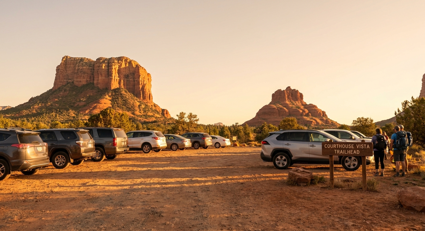
Parking and passes
This loop sits in the Red Rock Ranger District of the Coconino National Forest, which means you typically need a Red Rock Pass (or an accepted alternative) to park at most trailhead lots here.
Restrooms
Good beginner detail that matters: vault toilets are available at both Bell Rock Trailhead and Courthouse Vista Trailhead. There are no services on the trail itself, so handle business before you start.
Pass options
- Red Rock Pass: Available as a daily or weekly option at machines at many trailheads, at visitor centers, and at some local shops. Display it on your dashboard.
- America the Beautiful (Interagency) Pass: Accepted at most Coconino NF Red Rock Pass fee sites, but it does not apply to Arizona State Parks and it will not replace any shuttle, permit, or special-use systems. When in doubt, confirm current rules on the official Coconino NF / Red Rock Pass info page.
Good-to-know: Rules and acceptance can change, and machines occasionally go down. If you are unsure, buy a pass in town and keep your receipt.
Where to park
You have a few solid options. The best choice depends on whether you want the simplest loop start or the least stressful parking.
- Bell Rock Trailhead (most direct): Convenient access to the pathway and easy connectors toward Courthouse Butte. Fills fast mid-morning.
- Courthouse Vista Trailhead: Great views right from the lot and excellent access to the loop. Also popular for sunrise and sunset.
- Yavapai Vista Point and SR-179 signed vista pullouts (only where permitted): These can work as overflow when open and clearly signed for legal parking. Always follow posted signage. Parking tickets are not a vacation souvenir.
If you arrive and every lot is full, do not improvise onto vegetation or squeeze into “kind of” spots. Your easiest reset is to shift your hike earlier or later, or pivot to a quick coffee and come back when the turnover hits.
Future-proofing tip: Sedona parking and traffic strategies evolve. Before you go, it is smart to check for current alerts (closures, construction, major event weekends) on official forest or city channels.
Clockwise vs counterclockwise
You can hike this loop either direction, and both work. The difference is mostly about sun exposure, how the views reveal themselves, and whether you prefer a slightly rockier section early or late.
Clockwise (my default)
- Why it works: The route tends to ease you in with wide, friendly tread before you hit a few rockier, narrow bits near drainages and slickrock.
- Views: Courthouse Butte stays in front of you for long stretches, which is great for pacing and photo breaks.
- Best time: Morning, especially in warmer months, to reduce heat exposure.
Counterclockwise (great late-day light)
- Why it works: If you are hiking later, counterclockwise can put you in a position where the buttes glow as the sun drops.
- Feel: You may hit a couple of the slightly trickier footing sections earlier, when your legs are fresher.
One simple navigation cue: At signed junctions, keep choosing the option labeled Courthouse Butte Loop (not the various spur trails that peel off toward viewpoints). If you stop seeing Courthouse Butte as your main “anchor” and you start drifting into a web of side paths, pause and check your map.
My simple rule: If it is hot or you are truly new to desert hiking, go clockwise early. If you are chasing golden hour photos and temperatures are reasonable, pick the direction that keeps the sun off your face for as long as possible.
Trail conditions
This is an approachable loop, but it is still Sedona. The desert does not need big elevation to humble you.
Sunny sections
Expect limited shade for most of the loop. You will get occasional help from juniper and small trees, but this is not West Fork. The most exposed stretches are the long, open segments of the Bell Rock Pathway and parts of the loop that run across open flats.
Sandy sections
Some connectors and corners of the loop can get soft and sandy, especially after wind or heavy use. It is not deep dune sand, but it can be tiring for brand-new hikers. Shorter steps and a relaxed pace help.
Slick sections
After rain (or in winter when there is frost), watch for:
- Rock slabs: Smooth slickrock can be surprisingly slippery when damp.
- Drainage crossings: Mud can gather in low spots, and small stones can roll underfoot.
- Crypto soil edges: Stay on trail to protect the living soil crust and to avoid stepping onto unstable, eroded shoulders.
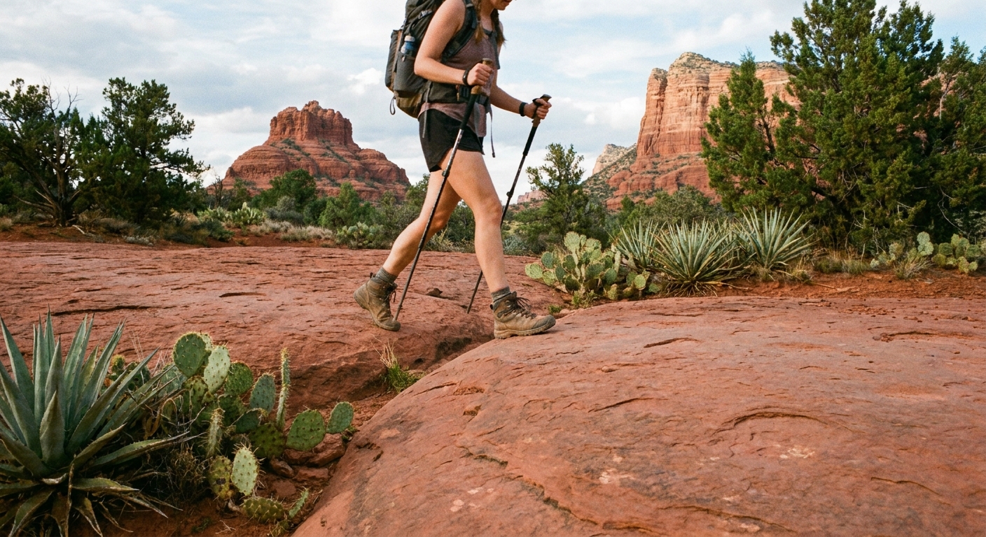
Shoe note: You do not need mountaineering boots, but you will be happier with a sneaker or hiking shoe that has real tread.
Trail traffic
Bell Rock is popular, but people spread out better here than on the classic one-photo-spot hikes.
Mountain bikes
Important beginner note: the Bell Rock Pathway is heavily used by mountain bikers. Stay alert, especially on gentle downhill stretches and near junctions where bikes can appear quickly. If you hear a bell or “on your left,” step to the side when safe and let riders pass. Everyone has a better day when nobody gets surprised.
Crowd timing
- Sunrise to 9:00 am: Cool temps, soft light, easiest parking.
- After 3:30 pm: Many day trippers are done, and the rocks start to glow. Bring a headlamp if you cut it close.
Busiest window
10:00 am to 2:00 pm tends to be the busiest and the hottest. If that is your only window, it is still doable, just plan for slower passing and carry more water than you think you need.
If you want “iconic Sedona” photos without waiting your turn, Bell Rock at sunrise is the cheat code.
Two-hour plan
This is my go-to itinerary when you want a satisfying hike that still leaves room for a long lunch, a shower, and a coffee that is not from a gas station.
0:00 to 0:15 | Park, pass, warm-up
Start at Bell Rock Trailhead or Courthouse Vista Trailhead. Quick gear check: water accessible, hat on, sunscreen applied. Use the restroom if you need it. Walk the first flat section at an intentionally easy pace. Let your body settle into the heat and elevation.
0:15 to 0:55 | Connector to the loop
Take the connector toward the Courthouse Butte Loop and commit to your chosen direction (clockwise is simplest for most beginners). Keep your eyes on trail signage at junctions. This area has multiple intersecting paths, and the “right” trail is usually the one that stays obvious and well-traveled.
0:55 to 1:25 | Scenic middle
This is the sweet spot where the loop feels like a moving postcard. Pace yourself and take short breaks in any shade you can find. If you want a little bonus without going full scramble, look for a gentle spur that climbs a few feet for a wider view.
1:25 to 1:45 | Optional Bell Rock spur
If you have energy, detour toward Bell Rock for a short viewpoint spur. You do not need to climb high to feel the drama of the formation. Turn around the moment you feel like you are using your hands more than you want to.
1:45 to 2:00 | Return on the pathway
Finish on the Bell Rock Pathway back to your trailhead. This is a great section for a cooldown walk and one last round of photos.
Beginner pacing target: Plan on a 2.0 mph moving pace and build in photo and water breaks. Sedona is not the place to speedrun your first hike.
Navigation tips
The loop area has lots of connectors, which is great for flexibility and also great for accidentally adding a mile when you did not mean to.
- Use an offline map: Download your map before you arrive. Cell service can be inconsistent.
- Follow the obvious tread: If the path suddenly becomes faint, overly sandy, or crisscrossed with social trails, pause and reassess.
- Check junction posts: Many intersections have signage, but not all. Confirm you are still circling Courthouse Butte and not wandering out toward other networks.
What to pack
- Water: At least 1 liter per person for a two-hour beginner hike, more in summer.
- Sun protection: Hat, sunglasses, and sunscreen. Shade is scarce.
- Traction: Shoes with decent tread for slickrock and loose gravel.
- Snacks: Something salty plus something quick like a bar or fruit snack.
- Layers: Mornings can be chilly in cooler months, even when the afternoon is warm.
- Headlamp: If you are starting late or chasing sunset.
Weather safety
If monsoon clouds build and you hear thunder, take it seriously. This landscape is beautiful and also very exposed. Turn around early rather than gambling on “one more viewpoint.”
Leave No Trace
This area sees heavy foot traffic, which makes small choices add up fast.
- Stay on established trails to protect fragile desert soil crust.
- Do not shortcut corners, even if you see other people doing it.
- Pack out everything, including orange peels and tissues.
- Respect wildlife and other hikers by keeping noise low and yielding appropriately on narrow sections.
After the hike
Bell Rock is perfectly positioned for the kind of trip I love: trail first, town comfort right after.
- Quick recovery move: Drive back toward Sedona and grab an iced coffee or cold drink before the midday rush.
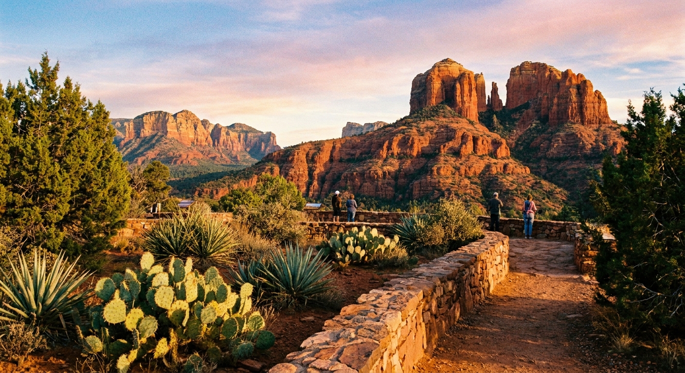
- Bonus scenic stop: If you have a few minutes, pull over at a viewpoint on the way into town for one last look at the red rock skyline.
FAQs
Is Bell Rock Pathway suitable for total beginners?
Yes. The main pathway is wide and mostly gentle. The loop adds distance but keeps the difficulty reasonable. The only “choose your own difficulty” part is scrambling up Bell Rock, which is optional.
Do I need to climb Bell Rock for good views?
No. You get iconic views from the pathway and loop. A small spur up to a lower viewpoint is plenty for most beginners.
Are dogs allowed?
Yes. Leashed dogs are allowed. Bring water for them too, and be extra mindful at junctions and on the Bell Rock Pathway where bikes pass frequently.
Can I do this instead of Devil’s Bridge if I hate crowds?
If your goal is classic Sedona scenery with less waiting and less congestion, this loop is one of the best swaps. You will still see people, but the trail network spreads hikers out.
Is the trail good after rain?
It can be, but expect slick rock slabs and muddy drainages. If conditions are wet, slow down and prioritize traction.