Best Day Hikes in Death Valley National Park
Maya Lin
Maya Lin is a travel journalist and outdoor enthusiast who believes the best trips combine rugged adventures with urban comforts. After spending six years backpacking across four continents, she founded Trail & Town Guide to help fellow travelers navigate both hidden mountain passes and bustling city neighborhoods with confidence.
Death Valley is the kind of place that makes your water bottle feel like a security blanket. It is stark, surreal, and wildly beautiful, but it plays by its own rules. The “easy” day hike that would be a casual stroll in Yosemite can turn serious fast here, thanks to extreme heat, big temperature swings, and very limited shade.
This guide focuses on five classic, high-reward day hikes you can realistically stitch into a long weekend based around Furnace Creek, the park’s most convenient hub for lodging, gas, food, and easy logistics. I’ll share what each hike feels like on the ground, when to go, how much water to carry, and how to stay smart when the desert starts flexing.
Before you hike: heat rules
Death Valley is home to the widely accepted hottest air temperature ever recorded on Earth: 56.7°C (134°F), measured at Furnace Creek (then Greenland Ranch) on July 10, 1913. Even in the cool season, sun exposure is no joke. Treat heat safety as part of your route planning, not an afterthought.
Entry fee and passes
You will need a park entry pass to enter Death Valley National Park. If you plan to visit multiple national parks this year, the America the Beautiful pass can pay for itself quickly. Fees and details can change, so confirm current rates on the official NPS site before you go.
Best seasons for day hiking
- Best: November through March for comfortable daytime temperatures and longer hiking windows. (Late March can start warming up fast on the valley floor.)
- Shoulder season: October and April can be great if you start early and keep hikes shorter.
- Not recommended for most hikers: May through September for exposed trails. If you visit in summer, plan sunrise-only walks near the car, then retreat to shade and air conditioning.
How much water to carry
There is often no water on trail in Death Valley. For most cool-season day hikes, here is a solid rule of thumb. Adjust for temperature, pace, exposure, and how your body runs in heat.
- Around 1 liter per hour of hiking, with a minimum of 3 liters per person even for shorter outings.
- 4 to 6 liters per person for longer routes, warmer days, or if you run hot.
- Electrolytes are strongly recommended. Bring salty snacks or tablets. Plain water alone can leave you feeling shaky and nauseated, especially if you are sweating hard.
Timing and trail strategy
- Start at sunrise. Desert light is gorgeous, and your body will thank you.
- Turn around earlier than you think. In heat, small problems compound quickly.
- Stay on established routes when possible. Slot canyons and washes can be confusing, and scrambling off-route wastes energy and water.
- Check conditions at the visitor center or on the official NPS site, especially after storms. Flash floods can reshape canyons and close roads.
- Do not count on cell service. Reception is limited and unreliable. Download offline maps before you arrive.
If the thought “I can probably make it with what I have” crosses your mind, take it as your cue to add water, start earlier, or pick a shorter hike.
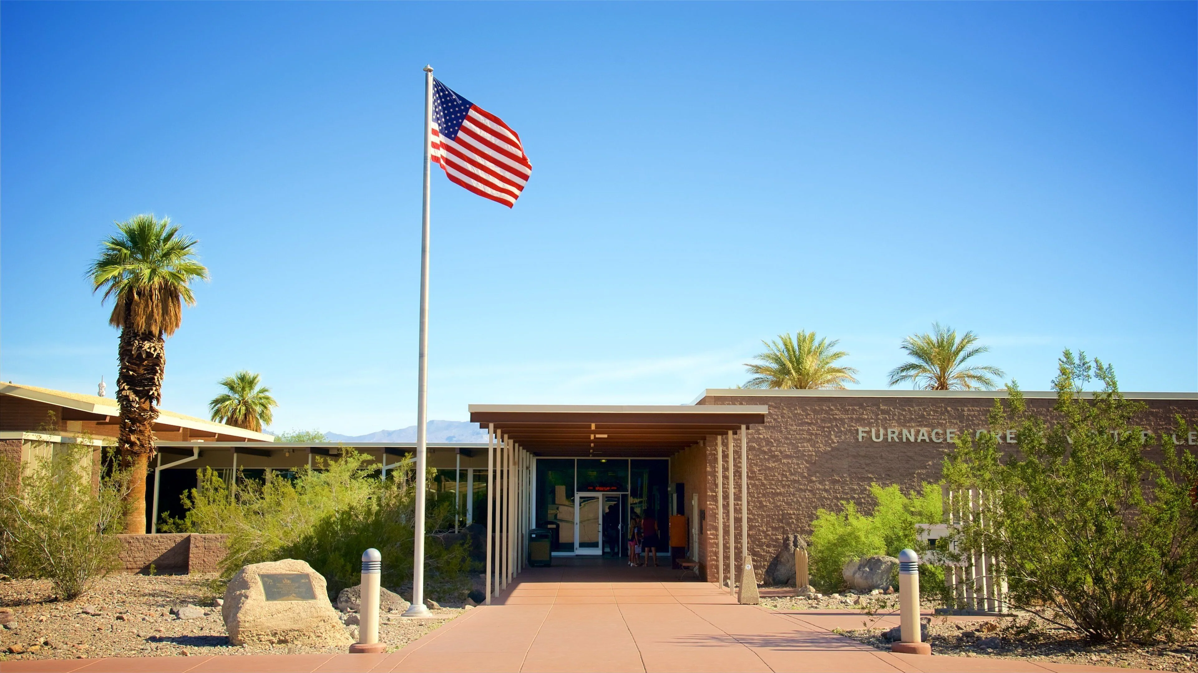
Why base in Furnace Creek
If you want a Death Valley trip that feels both adventurous and surprisingly comfortable, Furnace Creek is your sweet spot. It is central, has services, and puts you within easier reach of the park’s marquee viewpoints and trailheads.
- What you get: lodging options, a visitor center, food, gas, and a reliable place to top off water.
- What to plan for: distances in Death Valley are deceptively big. Even “nearby” hikes can mean an hour of driving, so group hikes by area.
- Road reality: storms can temporarily close roads or roughen access to trailheads. Always check current conditions before you commit.
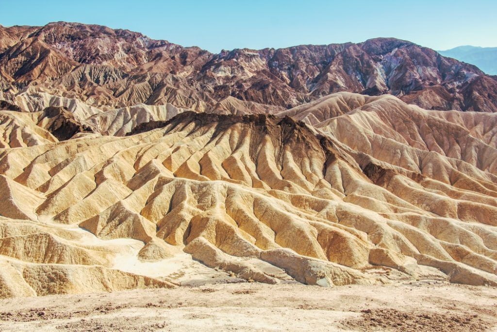
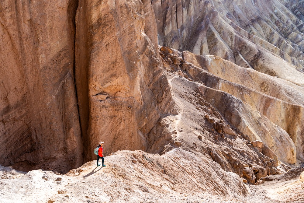
1) Golden Canyon
If you only do one hike near Furnace Creek, make it Golden Canyon. The walls glow honey-gold in morning light, and the route has that classic Death Valley feel: sculpted badlands, quiet corridors of rock, and the sense you are walking through an ancient, sunbaked painting.
Quick stats
- Difficulty: Easy to moderate
- Distance: ~3 miles round trip from the Golden Canyon trailhead to the Red Cathedral area (longer if you add Zabriskie Point connections)
- Time: 1.5 to 3 hours
- Best time: Sunrise to mid-morning
- Closest hub: Furnace Creek
What it’s like
The canyon starts wide, then tightens into smoother, more dramatic walls. The popular goal is Red Cathedral, a set of rust-colored cliffs at the end of a gentle climb. The best moment is when you look back and the badlands open up behind you like rippled waves.
Trail tips
- Bring a sun hat and sunglasses. Even in winter, the glare bounces off pale rock.
- After rain, the canyon can hold mud and small washouts. Good traction helps.
- If you want more mileage, you can connect routes in the broader badlands area, but do that only if temperatures are mild and you are confident with navigation.
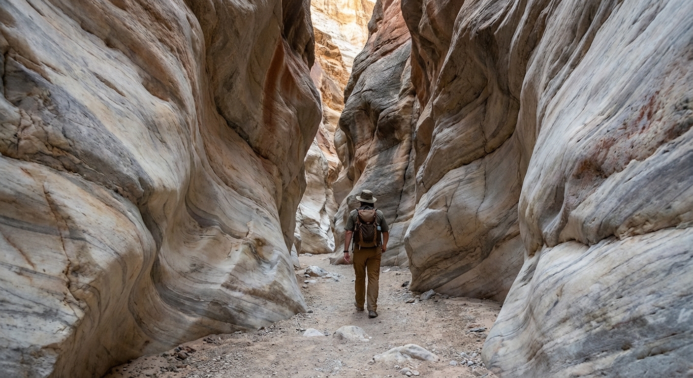
2) Mosaic Canyon
Mosaic Canyon is your “slot canyon meets geology lab” hike. It starts with smooth, polished limestone narrows, then opens into a rocky wash where you will see the park’s famous mosaic-like breccia embedded in the canyon walls.
Quick stats
- Difficulty: Moderate (some scrambling)
- Distance: ~4 miles round trip (many people turn around earlier)
- Time: 2 to 3 hours
- Best time: Morning, especially on warmer days
- Area: Near Stovepipe Wells (a reasonable drive from Furnace Creek)
What it’s like
The opening narrows are the star: marble-smooth rock underfoot, curving walls, and little bursts of light overhead. Further in, the route becomes more of a wash hike with a few short scrambles. Many hikers turn around at the first dryfall if they do not feel comfortable climbing it, and that is still a great experience.
Trail tips
- Wear shoes with grip. Polished rock can be slick.
- Keep an eye on weather. Slot-like sections are not where you want to be if storms are in the forecast.
- This is a great hike for cooler months when you want canyon shade without committing to an all-day trek.
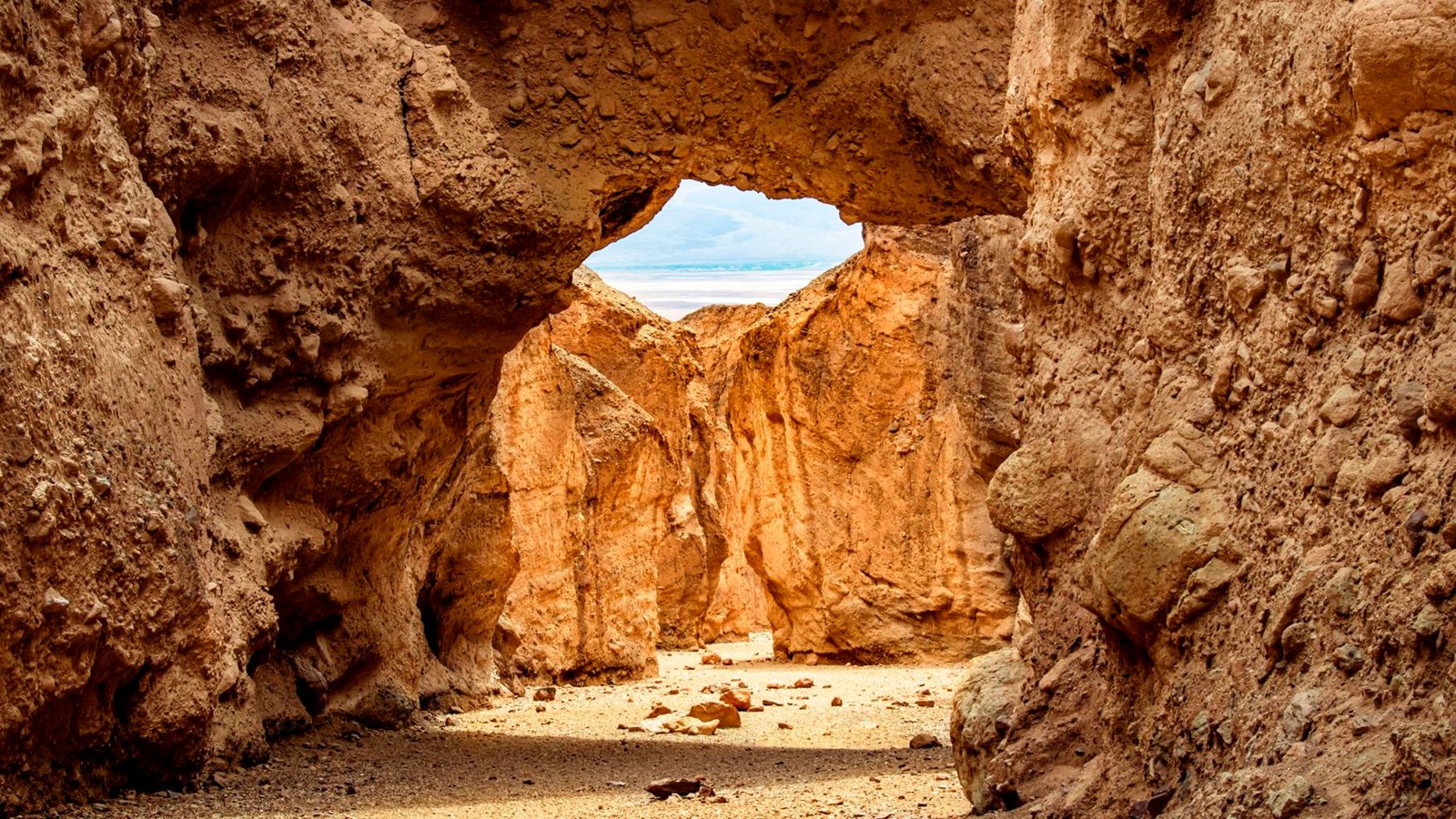
3) Natural Bridge
Natural Bridge is the hike I recommend when you want something short, sweet, and genuinely surprising. The payoff is a big, clean stone arch tucked into a side canyon, the kind of feature that makes you stop mid-sip and say, “How is this real?”
Quick stats
- Difficulty: Easy to moderate
- Distance: ~1 to 1.5 miles round trip depending on where you measure and how much you wander at the bridge
- Time: 45 minutes to 1.5 hours
- Best time: Morning or late afternoon in cool season
- Closest hub: Furnace Creek
What it’s like
The trail follows a rocky wash into a narrowing canyon. It is not long, but it is classic desert hiking: uneven stones, a few small steps, and the quiet echo of your own footsteps. When you reach the bridge, you can walk up to it and explore the base area.
Trail tips
- Bring a little extra water anyway. Short hikes are where people under-pack.
- If you are traveling with mixed fitness levels, this is an ideal “everyone wins” option.
- Watch for loose rock in the wash, especially after storms.
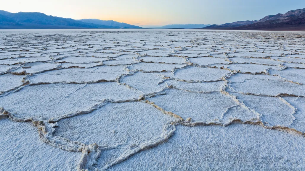
4) Badwater Salt Flats
Badwater Basin is iconic for a reason. It is also the lowest point in North America at 282 feet (86 meters) below sea level. Walking out onto the salt flats feels like stepping onto another planet, especially when the polygon patterns are crisp and the mountains rise like jagged teeth in the distance.
Quick stats
- Difficulty: Easy (but exposed)
- Distance: Flexible, 0.5 to 2+ miles total depending on how far you wander
- Time: 30 minutes to 2 hours
- Best time: Sunrise or sunset in cool season
- Closest hub: Furnace Creek
What it’s like
This is less of a “trail” and more of a choose-your-own wander. The magic is in the details: the crunch of salt underfoot, the mirror-like sheen after rare rains, and the way distance plays tricks on your eyes.
Safety and etiquette
- Heat is amplified here. The flats reflect sunlight, and there is no shade. Time it early or late.
- Footwear matters. Salt can be sharp and the edges can irritate skin in flimsy sandals.
- Respect the salt crust. Footprints happen, but try to avoid trampling the most fragile nearshore edges near the parking area when possible, follow posted guidance, and pack out every scrap of trash.
5) Dante’s Ridge
If you want the big-picture moment, head to Dante’s View and walk along the ridge. From up high, Death Valley’s extremes make visual sense: the salt flats below, the surrounding ranges, and the sheer scale that photos never quite capture. It is also the perfect contrast to Badwater Basin: lowest point down there, high country air up here.
Quick stats
- Difficulty: Easy to moderate (wind and exposure can add challenge)
- Distance: Flexible ridge walk, 1 to 4 miles total depending on turnaround
- Time: 45 minutes to 2.5 hours
- Best time: Sunrise for light, or later in the day when it is often cooler than the valley floor (but still sunny and sometimes very windy)
- Closest hub: Furnace Creek
What it’s like
The ridge is open, airy, and often windy. This is your contrast hike: after canyon walls and salt flats, you get a sweeping overlook where you can trace roads, basins, and peaks like a relief map.
Trail tips
- Bring a light layer. The viewpoint can be significantly cooler and windier than the valley floor.
- Stay back from crumbly edges, especially in gusts.
- This is a fantastic “first stop” to orient yourself to the park’s geography.

Sample 2-day plan
If you like a trip that balances big sights with sensible driving, here is a simple way to group these hikes.
Day 1: Close to base
- Sunrise: Golden Canyon to Red Cathedral
- Mid-morning: Return to Furnace Creek for water refill and a snack
- Late afternoon: Natural Bridge
- Sunset option: Badwater Salt Flats walk
Day 2: Big view, then narrows
- Morning: Dante’s Ridge walk
- Midday break: Lunch and rest (this is your heat-avoidance window)
- Afternoon: Mosaic Canyon (best when temperatures are mild and you have time to explore)
Driving note: Dante’s View is east of Furnace Creek, while Mosaic Canyon is west toward Stovepipe Wells. Expect roughly 1.5 hours of total driving for the day, depending on stops and road conditions.
Day-hike packing list
This is the desert, so your daypack is your lifeline. Here is what I consider the non-negotiable kit for these hikes.
- Water: 3 to 6 liters per person depending on route, season, and your personal needs
- Electrolytes: tablets, mix, or salty snacks
- Sun protection: wide-brim hat, sunscreen, sunglasses
- Footwear: grippy trail shoes (rock and salt punish flimsy soles)
- Layers: light wind layer for Dante’s View, warmer layer for winter mornings
- Navigation basics: offline map downloaded, plus a simple backup (paper map or notes)
- Emergency essentials: headlamp, basic first aid, whistle
- Leave No Trace basics: pack out trash, respect closures, and do not climb on delicate formations
One more practical tip: keep extra water in your car. Even if you never need it on trail, it is the best “just in case” purchase you can make in Death Valley.
Final notes
Death Valley rewards humility. Start early, carry more water than you think you need, and choose hikes that match the season. If you do that, these day hikes deliver the full spectrum of what makes the park unforgettable: glowing canyons, polished narrows, salt-flat surrealism, and a ridge-top view that makes you feel very small in the best possible way.
If you’re planning a desert double-header, these hikes also pair beautifully with a cooler-season trip to Joshua Tree. Same desert magic, a totally different vibe.