Best Day Hikes in Glacier National Park
Maya Lin
Maya Lin is a travel journalist and outdoor enthusiast who believes the best trips combine rugged adventures with urban comforts. After spending six years backpacking across four continents, she founded Trail & Town Guide to help fellow travelers navigate both hidden mountain passes and bustling city neighborhoods with confidence.
Glacier National Park is the kind of place that makes you feel like you accidentally wandered into a postcard that forgot to be subtle. One minute you are sipping a latte in town, the next you are hiking past turquoise lakes, waterfall spray, and mountain goats posted up like they own the ridgeline.
This guide covers Glacier’s best day hikes, organized by difficulty, with the unglamorous details that actually make your day go smoothly: where to park, when trails open, what “seasonal” really means up here, and which nearby towns are best for sleeping well and eating better.
Before you pick a trail
Know your “Glacier math”
- Driving time is part of the hike. Trailheads are spread out and the road is slow and scenic. Build in extra time for parking and wildlife traffic.
- Elevation hits differently. Many hikes start around 3,000 to 6,600+ feet, then climb fast.
- Weather changes quickly. Sun at the trailhead can turn into wind, hail, or smoke on the ridge.
Vehicle reservations (yes, it changes)
Glacier has used a Vehicle Reservation System in recent seasons for certain corridors during peak times. The details can change year to year and can differ by area and time of day (for example: Going-to-the-Sun Road and sometimes Many Glacier, North Fork, or other entrances).
- What you need to know: a vehicle reservation is separate from your park entrance pass.
- Day hikes: you do not need a backcountry permit for these hikes, but you might need a vehicle reservation to reach the trailhead during certain hours.
- Where to check: the NPS Glacier page for current road status, trail conditions, construction, shuttle info, and reservation rules.
Seasonal access notes
Glacier’s signature routes revolve around Going-to-the-Sun Road. In a typical year, the full road opens sometime between late June and mid-July, but the exact date varies a lot. Early snow can temporarily shut things down as early as September, and the road typically closes to through-traffic in October.
- Early season (May to mid June): Lower elevation hikes shine (Avalanche area can be good, depending on snow). Expect closures higher up.
- Peak season (late June through September): Most iconic trails are accessible. Also, it is the busiest time for parking and trail congestion.
- Shoulder season (mid September to October): Gorgeous light and fewer people, but shorter days and early snow risk.
Pro tip: “Open” does not always mean “dry.” Snowfields and icy sections can linger well into summer near Logan Pass and along exposed trails.
Parking, shuttles, and bathrooms
- Arrive early. For popular trailheads, arriving by 7:00 to 8:00 a.m. can be the difference between hiking and circling like a stressed-out vulture.
- Use the shuttle when it is running. It can save your day on Going-to-the-Sun Road. Shuttle season, routes, and last return times vary by year, so confirm before you go.
- Restrooms and water: Major hubs (visitor centers and big trailheads) usually have restrooms. Potable water is not guaranteed everywhere, so top off when you can and do not count on streams for easy refills.
- Bear spray is non-negotiable. Carry it accessible, not buried in your pack, and know how to use it.
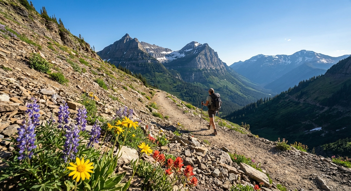
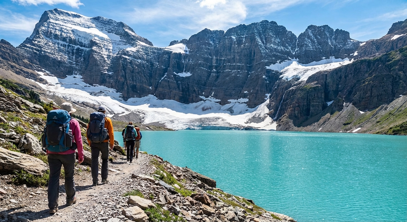
Easy day hikes
Perfect if you are traveling with kids, easing into altitude, or you simply want a spectacular afternoon that still leaves time for a shower and dinner in town.
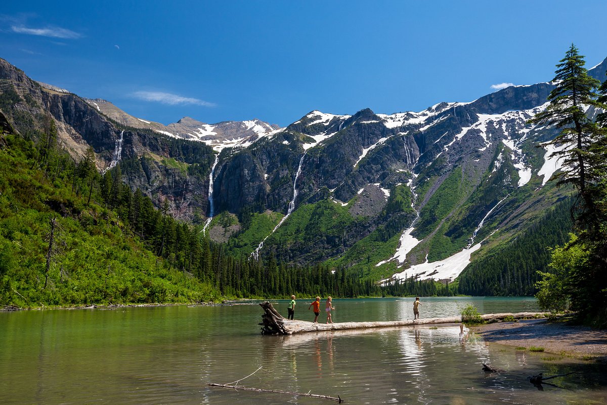
Avalanche Lake
Why it’s worth it: This is Glacier’s “how is this real?” lake walk. You finish at a bowl of peaks with multiple waterfalls spilling down the far wall. It feels cinematic even when the trail is busy.
- Distance: about 5.9 to 6.0 miles round trip
- Elevation gain: about 700 feet
- Difficulty: Easy to moderate
- Trailhead: Avalanche Creek / Trail of the Cedars (Going-to-the-Sun Road)
- Logistics: Parking fills fast. Shuttle access can help in peak season.
- Season notes: Best once Going-to-the-Sun Road access is open far enough to reach the trailhead. Snow can linger early.
Trail of the Cedars
Why it’s worth it: A short boardwalk loop through old-growth cedar and hemlock that feels like a temperate rainforest cameo in the Northern Rockies.
- Distance: about 0.9 to 1.0 mile loop
- Elevation gain: minimal
- Difficulty: Easy
- Trailhead: Trail of the Cedars (near Avalanche Creek)
- Logistics: Great “arrival day” hike when you are still getting oriented.
- Season notes: Often one of the earlier accessible options, depending on road opening.
Rocky Point (Lake McDonald)
Why it’s worth it: A mellow shoreline walk that ends at a classic Lake McDonald view, especially pretty in the morning when the water is glassy.
- Distance: about 1.9 miles round trip
- Elevation gain: minimal
- Difficulty: Easy
- Trailhead: Lake McDonald Lodge area
- Logistics: Pair it with a lodge visit or a boat ride for a very satisfying low-key day.
- Season notes: Great spring and fall option when higher trails are snowy.
Moderate day hikes
These are the hikes that make you feel like you truly earned your dinner. Expect steady climbing, changing scenery, and that “I could do one more mile” confidence as long as you packed snacks.
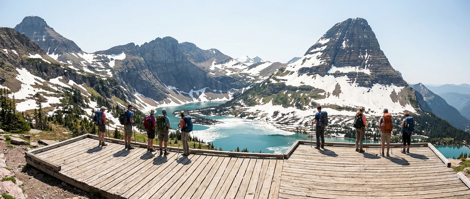
Hidden Lake Overlook
Why it’s worth it: Big views with a relatively short distance, plus a decent chance of mountain goats and marmots. The overlook is the payoff even if you skip the steeper descent to the shoreline.
- Distance: about 2.7 to 3.0 miles round trip to the overlook (longer if you go down to the lake)
- Elevation gain: about 500 to 600 feet to the overlook
- Difficulty: Moderate
- Trailhead: Logan Pass Visitor Center
- Logistics: Parking is extremely competitive. Arrive very early or plan around shuttle access.
- Season notes: Often snow-covered into early summer. Early season can mean slick snowfields, so trekking poles and traction can be helpful.
St. Mary and Virginia Falls
Why it’s worth it: A waterfall-focused hike that gives you multiple payoffs without crushing elevation. Virginia Falls is the headline, but the whole corridor is lush and loud with water.
- Distance: about 3.6 miles round trip (to Virginia Falls)
- Elevation gain: about 500 feet
- Difficulty: Moderate
- Trailhead: St. Mary Falls trailhead (Going-to-the-Sun Road, east side)
- Logistics: Popular. Go early to avoid the parking stress and the midday crowd.
- Season notes: Great mid-summer when everything is roaring. In dry years, late summer flow can be smaller but still pretty.
Grinnell Lake
Why it’s worth it: You get a bright, milky-turquoise lake at the base of serious peaks, with an easier profile than the glacier hike above it. It is an excellent “I want Many Glacier scenery without committing to a big climb” option.
- Distance: about 7.0 miles round trip
- Elevation gain: about 200 to 300 feet
- Difficulty: Moderate
- Trailhead: Many Glacier Hotel area
- Logistics: Many Glacier is its own little universe. Plan extra drive time and do not assume you will find parking at noon.
- Season notes: Access depends on Many Glacier road conditions and seasonal openings.
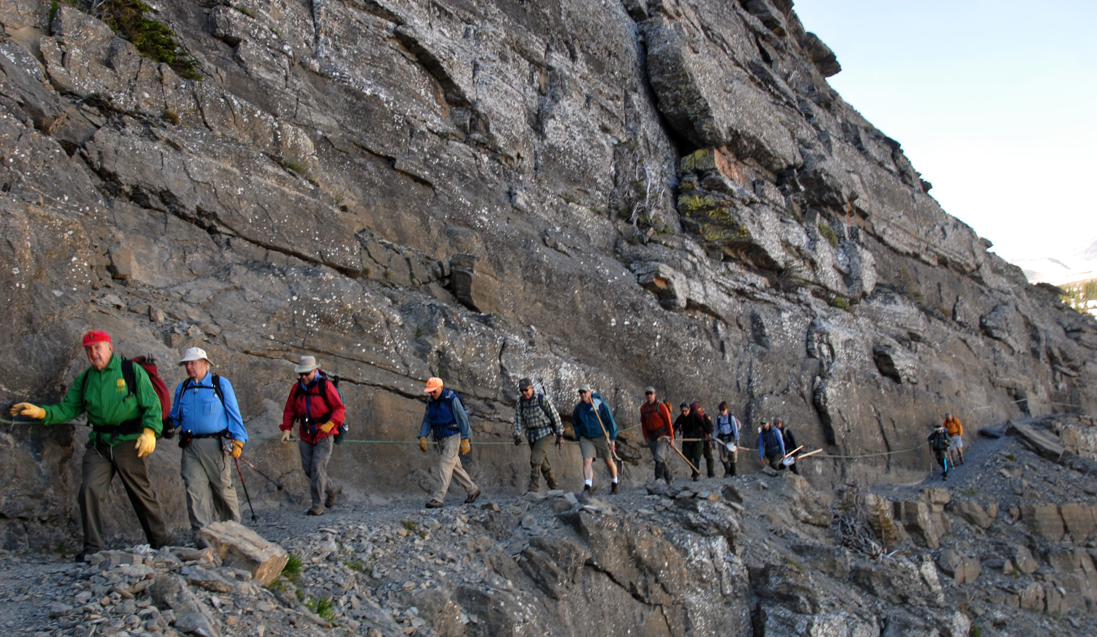
Hard day hikes
These are the ones people talk about for years. They require fitness, time, and a willingness to keep going even when the weather is being dramatic. Bring more water and food than you think you need, and start early enough that you are not racing sunset back to the car.
Highline Trail (Logan Pass to The Loop or out-and-back)
Why it’s worth it: The Highline is pure Glacier magic: a narrow path etched into the Garden Wall with nonstop views and frequent wildlife sightings. If you want one hike that feels like the park’s greatest hits album, this is it.
- Distance: commonly 11.6 to 12.0 miles point-to-point (Logan Pass to The Loop), or shorter as an out-and-back
- Elevation gain: varies by route. Expect rolling terrain, plus a big climb if you add the Grinnell Glacier Overlook spur.
- Difficulty: Hard
- Trailhead: Logan Pass (end at The Loop if doing point-to-point)
- Logistics: The shuttle can be your best friend. If you go point-to-point, you need a plan for transportation back to your start.
- Season notes: Snow and ice can linger, especially early season. Wind exposure is real. Traction can be a smart add-on.
Grinnell Glacier
Why it’s worth it: This hike is a full narrative arc: lakes, waterfalls, wildflowers, and then the glacier basin itself. The final approach is where you start realizing just how alive the landscape is, with moving ice, shifting rock, and that cold air spilling down the valley.
- Distance: about 10.0 to 11.0 miles round trip if hiking the whole way (route can vary)
- Boat option: you can shorten the mileage by taking the Many Glacier boat across Swiftcurrent Lake and Lake Josephine when it is running
- Elevation gain: about 1,600 to 2,200 feet (depending on route and turnaround)
- Difficulty: Hard
- Trailhead: Many Glacier area (near Many Glacier Hotel)
- Logistics: Start early. Parking and trail traffic are intense in peak season. If you can stay in or near Many Glacier, future-you will be grateful at 5:30 a.m.
- Season notes: Best mid to late summer when snow is mostly melted. The upper trail can still hold snowfields some years.
Iceberg Lake
Why it’s worth it: A glacier-carved amphitheater with floating ice well into summer, framed by sheer cliff walls that feel almost Yosemite-like. Wildlife sightings are common along the approach.
- Distance: about 9.6 miles round trip
- Elevation gain: about 1,200 feet
- Difficulty: Hard
- Trailhead: Many Glacier area
- Logistics: Limited parking. Bring layers, the lake can feel chilly even on warm days.
- Season notes: Ice often lingers into mid or late summer. Early season snow can make access tricky.
Ptarmigan Tunnel
Why it’s worth it: You literally hike to a man-made tunnel blasted through the mountain and step through to an entirely different world on the other side. It is one of the most uniquely “Glacier” objectives you can do in a day.
- Distance: about 10.6 to 11.0 miles round trip
- Elevation gain: about 2,300 feet
- Difficulty: Hard
- Trailhead: Many Glacier area
- Logistics: Bring a headlamp just in case, and expect cooler temperatures near the tunnel.
- Season notes: The tunnel is typically only passable once snow is cleared, often mid-summer into early fall. Check status.
Honorable mentions
If your dates, reservations, or weather do not line up with the big-name corridors, these are excellent backups that still feel like Glacier.
- Scenic Point (Two Medicine): a leg-burner with huge views and fewer crowds than Logan Pass on many days.
- Swiftcurrent Pass (Many Glacier): a classic, challenging climb with big alpine payoff and strong wildlife odds.
- Bowman Lake and Kintla Lake (North Fork): remote, dusty-road energy with big water, big quiet, and a different side of the park. Access and vehicle reservations can apply depending on the year.
Pick the right area
West Glacier and Lake McDonald
Best for: first-timers, families, and anyone who wants easy access to classic scenery without committing to huge mileage.
- Top hikes: Avalanche Lake, Trail of the Cedars, Rocky Point
- Vibe: lodge history, lake views, and easier logistics than the park’s far edges
Logan Pass
Best for: bucket-list alpine hiking if you can handle crowds and parking competition.
- Top hikes: Highline Trail, Hidden Lake Overlook
- Vibe: high altitude, big exposure, and scenery that makes you stop mid-sentence
Many Glacier
Best for: the iconic “Glacier postcard” hikes, serious wildlife potential, and a slightly more remote feel.
- Top hikes: Grinnell Glacier, Iceberg Lake, Ptarmigan Tunnel, Grinnell Lake
- Vibe: dramatic peaks, historic hotel energy, and long, rewarding trail days
St. Mary, Babb, and East Glacier
Best for: east side trail access, early starts without the cross-park commute, and an easier launch point for Many Glacier and Two Medicine.
- St. Mary: the most common east side basecamp for Going-to-the-Sun Road access and east side trailheads
- Babb: a practical home base for Many Glacier days
- East Glacier Park Village: a good hub for Two Medicine and a quieter, small-town feel
What to pack
- Bear spray plus a holster so it is reachable
- Layers: a light insulating layer and a rain jacket even if the forecast looks friendly
- Water and electrolytes: enough for your route, plus extra if it is hot or smoky
- Food: real calories, not just “two granola bars and optimism”
- Sun protection: hat, sunglasses, sunscreen (alpine sun is sneaky)
- Navigation: downloaded maps or a paper map as backup
- Headlamp: small, lightweight, and clutch if you are delayed
- Optional but smart early season: trekking poles and microspikes for lingering snowfields on high trails
Flying into FCA with a tight suitcase: Glacier is not the place to under-pack your day hiking kit. If you bring one extra thing, make it a proper rain layer. If you bring two, make the second bear spray.
Where to stay and eat
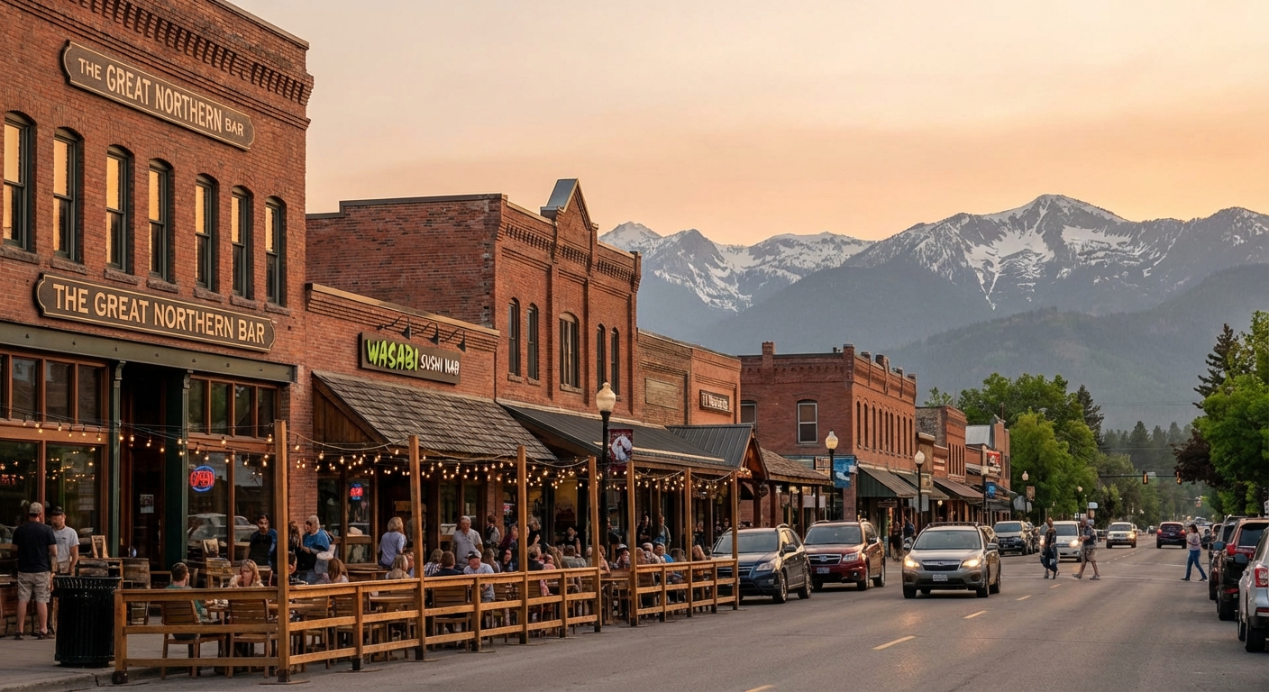
Whitefish
Why stay here: Whitefish is the charming, walkable option with a lively food scene, good coffee, and an easy vacation rhythm. It is a favorite for travelers who want big hike days followed by a great dinner and a place that stays open after 8:00 p.m.
- Best for: couples, friend trips, anyone who wants a “mountain town” feel
- Food and coffee: prioritize local coffee shops and restaurants that source regionally when you can
- Driving notes: straightforward drive to the west entrance, longer if you are targeting Many Glacier daily
Kalispell
Why stay here: Kalispell is usually more budget-friendly and practical. Think more options for larger hotels, grocery runs, and last-minute gear errands. If you like logistics that just work, Kalispell is your friend.
- Best for: families, budget-minded travelers, road trippers who value convenience
- Food and supplies: excellent for stocking a cooler and packing lunches for early trail starts
- Driving notes: similar access to West Glacier, plus a useful hub if you are mixing park days with other Flathead Valley plans
St. Mary and Babb
Why stay here: If your trip is Many Glacier heavy or you want easy access to east side hikes, staying on the east side is the move. It is less “walkable foodie town” and more “bed early, trail at dawn.” Which, honestly, is a great vacation rhythm too.
- St. Mary: best all-around east side basecamp for Going-to-the-Sun Road and waterfall hikes
- Babb: best for Many Glacier access
- East Glacier: best for Two Medicine days
Quick base-camp strategy
- Mostly west side hikes (Avalanche, Lake McDonald, Logan Pass): base in Whitefish or Kalispell for easy mornings.
- Multiple Many Glacier hikes: base in St. Mary or Babb if you can, or plan a dedicated Many Glacier day to avoid exhausting commutes.
Sample 2-day itinerary
Day 1: West side classics
- Early: Avalanche Lake
- Midday: Lake McDonald shoreline time and a picnic
- Late: Trail of the Cedars if you want a short bonus loop
Day 2: Alpine pick
- Option A: Highline Trail (go early and plan your shuttle)
- Option B: Hidden Lake Overlook (shorter mileage, huge views)
- Option C: Many Glacier day for Grinnell Glacier or Iceberg Lake
If you are only going to do one big day, pick the hike that fits your legs and your logistics. Glacier rewards both the ambitious and the unhurried.
Safety and etiquette
- Give wildlife space. The NPS guidance is at least 100 yards from bears and wolves and at least 25 yards from other wildlife. If you are close enough for a perfect phone portrait, you are too close.
- Hike in groups when possible. Especially on quieter trails.
- Stay on trail. Alpine plants grow slowly and recover even more slowly.
- Turn around if conditions change. Wind, lightning, or heavy smoke are legitimate reasons to call it.
Glacier is wild in the best way. Treat it like a privilege, not a theme park, and you will have the kind of day that keeps replaying in your head long after you are home.