Best One-Day Scenic Drives in US National Parks
Maya Lin
Maya Lin is a travel journalist and outdoor enthusiast who believes the best trips combine rugged adventures with urban comforts. After spending six years backpacking across four continents, she founded Trail & Town Guide to help fellow travelers navigate both hidden mountain passes and bustling city neighborhoods with confidence.
Some days you want the drama of a national park without committing to miles of switchbacks or a pre-dawn trailhead scramble. I get it. The best scenic drives deliver that big, cinematic payoff from the comfort of your car, with plenty of quick pullouts for photos, picnics, and a little leg-stretching.
Below are 12 of the best one-day scenic drives in US national parks, chosen specifically because you can enjoy them without hiking. No hikes required, though a few stops have optional short, mostly flat walks if you want to stretch your legs. Each drive includes distance, realistic drive time (not just “Google Maps time”), best season, can’t-miss stops, and a gateway town where you can refuel with real food and a good bed.
Before you go: quick logistics that save your day
- Start early. In popular parks, the best light and the easiest parking at overlooks happen before 9 am.
- Check road status the night before. High-elevation roads close for snow, construction, or wind with almost no mercy.
- Know if you need a reservation. Several parks now use timed entry or vehicle reservations at peak times. Check the park site before you build your day around one road.
- Pack like a minimalist. Water, snacks, layers, phone charger, and a small trash bag. That is 90 percent of success.
- Plan for pullouts. Your drive time can double if you stop often, and you should. That is the point.
- Do not count on services. Some of these routes have limited fuel and food once you are inside the park. Top off and bring snacks.
- Know your vehicle limits. Some roads have length restrictions, steep grades, or tight turns. If you are in an RV, verify park rules first.
12 one-day scenic drives worth building a trip around
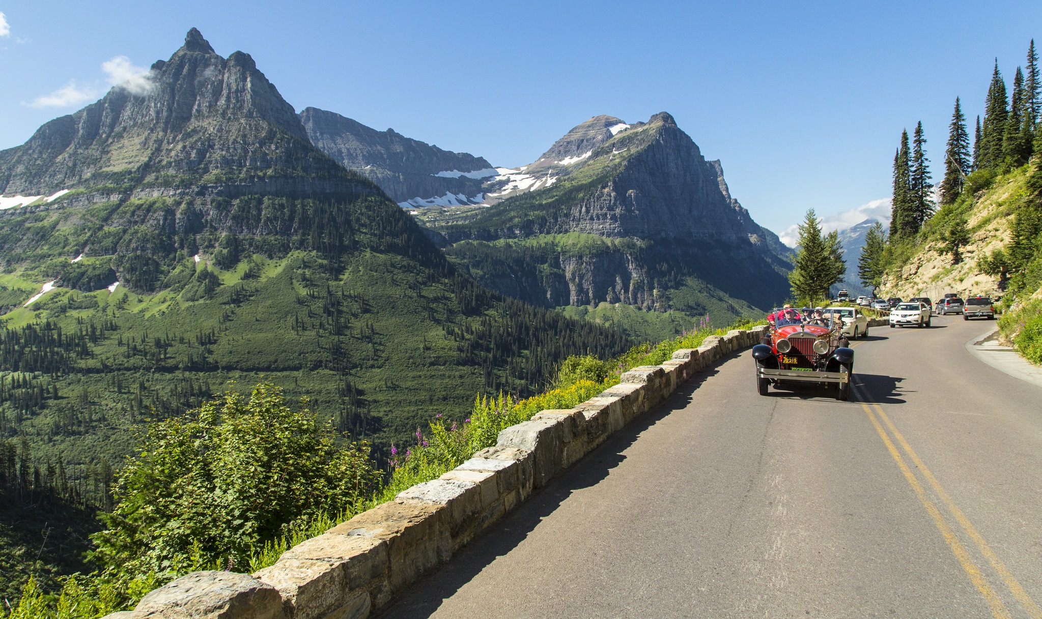
1) Going-to-the-Sun Road (Glacier National Park, Montana)
Distance: ~50 miles one-way (Apgar Village to St. Mary)
Estimated time: 2 to 4 hours one-way with stops (longer in peak summer traffic)
Best season: Late June to mid-September (varies by snow year)
Key overlooks and photo stops:
- Lake McDonald for early morning reflections
- The Loop for the classic cliff-hugging road view
- Logan Pass visitor area (arrive early for parking)
- Big Bend for sweeping valley shots
- St. Mary Lake pullouts for water and peaks in one frame
Nearest gateway towns: West Glacier (west side) or St. Mary (east side) for lodging and quick meals
Maya tip: If you only have one “linger” stop, make it Logan Pass and bring a thermos coffee. Even from the parking area, the alpine vibe is immediate.
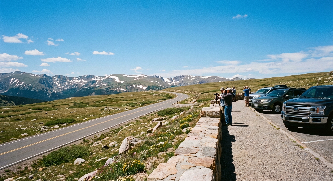
2) Trail Ridge Road (Rocky Mountain National Park, Colorado)
Distance: ~48 miles one-way (Estes Park to Grand Lake via US-34)
Estimated time: 2 to 4 hours with viewpoints and wildlife pauses
Best season: Late May to October (snow can close it anytime)
Key overlooks and photo stops:
- Many Parks Curve Overlook for big valley panoramas
- Forest Canyon Overlook for depth and drama
- Alpine Visitor Center for tundra views and a warm drink
- Medicine Bow Curve for the iconic sweeping roadway shot
Nearest gateway towns: Estes Park (east) and Grand Lake (west)
3) Tioga Road (Yosemite National Park, California)
Distance: ~47 miles one-way (Crane Flat to Tioga Pass)
Estimated time: 2 to 5 hours depending on stops and summer congestion
Best season: Late June to October (opening depends on snowpack)
Key overlooks and photo stops:
- Tuolumne Meadows roadside viewpoints for wide open high-country scenes
- Olmsted Point for that polished-granite, endless-forest perspective
- Tenaya Lake pullouts for water-and-mountain shots
- Tioga Pass for the “on top of the world” feel
Nearest gateway towns: Lee Vining (east side) or Groveland (west side, longer approach)
Maya tip: Yosemite Valley is incredible, but Tioga feels like a different planet. If the road is open, it is the easiest way to see Yosemite’s high country without hiking.
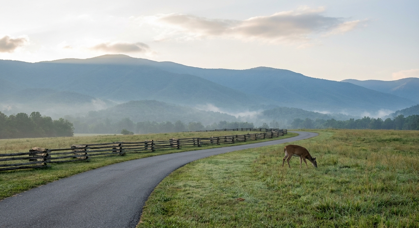
4) Cades Cove Loop Road (Great Smoky Mountains National Park, Tennessee)
Distance: 11 miles loop
Estimated time: 2 to 4 hours (wildlife traffic is real)
Best season: Spring through fall; early morning year-round is best for wildlife
Key overlooks and photo stops:
- Historic churches and cabins right off the road
- Open valley pullouts for deer and turkey spotting
- John Oliver Place for a classic Smokies homestead scene
Nearest gateway towns: Townsend (quiet, closest) or Gatlinburg (more hotels and dining)
5) Zion Canyon Scenic Drive (Zion National Park, Utah)
Distance: ~8 miles one-way (Zion Canyon Visitor Center to Temple of Sinawava)
Estimated time: 2 to 5 hours using the in-park shuttle during shuttle season (in winter, private vehicles may be allowed and times can be shorter)
Best season: March to May and September to November for pleasant temps
Key overlooks and photo stops:
- Court of the Patriarchs viewpoint for towering sandstone
- Big Bend for the classic canyon curve
- Weeping Rock area stop for close-up canyon walls (check for any closures)
- Temple of Sinawava for the canyon narrowing dramatically
Nearest gateway town: Springdale for lodging, coffee, and post-drive patios
Maya tip: Treat this like a “drive with frequent hop-offs.” The shuttle makes it easy to do quick, low-effort viewpoints without committing to hikes.
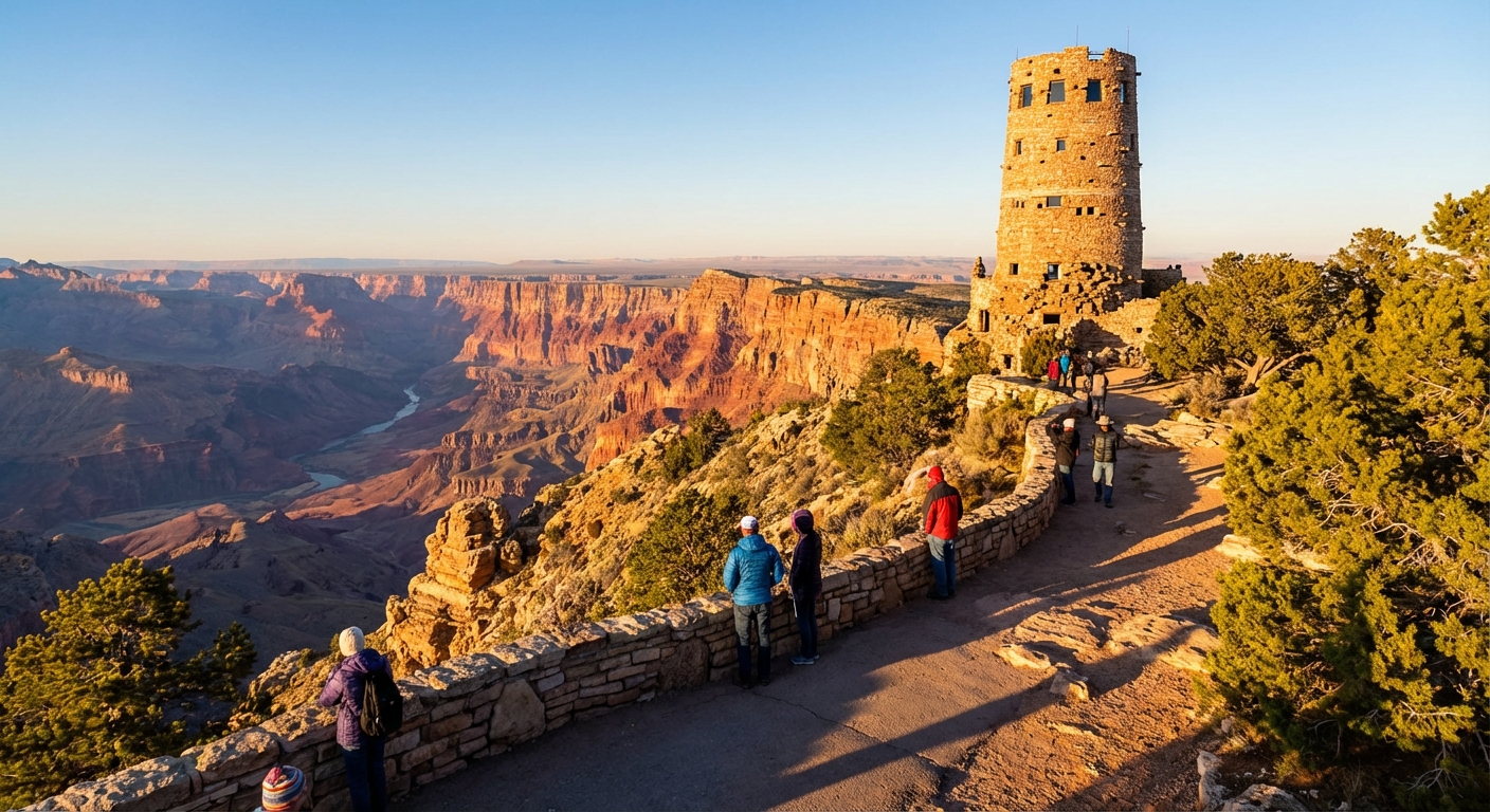
6) Desert View Drive (Grand Canyon National Park, Arizona)
Distance: ~23 miles one-way (Grand Canyon Village to Desert View Watchtower)
Estimated time: 2 to 4 hours with overlooks, more at sunrise or sunset
Best season: Spring and fall for crisp visibility; winter can be stunning and quieter
Key overlooks and photo stops:
- Grandview Point for big, classic South Rim views
- Moran Point for layered color and a wide horizon feel
- Lipan Point for Colorado River viewpoints and serious depth
- Tusayan Ruin for history with a view nearby
- Desert View Watchtower for a grand finale viewpoint
Nearest gateway towns: Tusayan (closest) or Flagstaff (more dining and lodging variety)
7) Badlands Loop Road (Badlands National Park, South Dakota)
Distance: ~31 miles one-way (SD-240 through the main scenic section)
Estimated time: 2 to 4 hours with frequent pullouts
Best season: Spring and fall; summer is hot but sunrise is excellent
Key overlooks and photo stops:
- Big Badlands Overlook for the first “wow” moment
- Yellow Mounds Overlook for surreal color bands
- Pinnacles Overlook for sweeping ridgelines
- Hay Butte Overlook for wide-open prairie context
Nearest gateway town: Wall (yes, home of Wall Drug, and surprisingly convenient)
Maya tip: Badlands rewards soft light. If you can, drive it twice, once at sunrise and again near sunset, and it feels like two different parks.
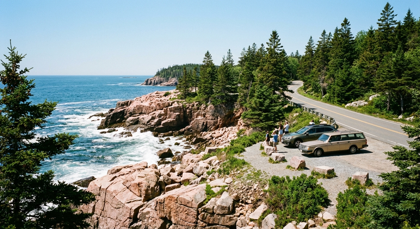
8) Park Loop Road (Acadia National Park, Maine)
Distance: ~27 miles loop (plus short spurs, including Cadillac Mountain Road)
Estimated time: 3 to 6 hours with stops, especially in summer
Best season: September to mid-October for fall color; summer for long days
Key overlooks and photo stops:
- Sand Beach for ocean-meets-mountain scenery
- Thunder Hole for wave action (best near high tide)
- Otter Cliff for dramatic coastal views
- Cadillac Mountain Road (timed entry often required) for summit panoramas
Nearest gateway town: Bar Harbor for seafood, bakeries, and easy lodging options
9) Rim Drive (Crater Lake National Park, Oregon)
Distance: ~33 miles loop
Estimated time: 2 to 5 hours depending on snow-free season and how often you stop
Best season: July to September for the highest chance of full loop access
Key overlooks and photo stops:
- Sinnott Memorial Overlook for that unreal blue water
- Watchman Overlook for Wizard Island views
- Cloudcap Overlook (when open) for a higher vantage
- Pumice Castle Overlook for quirky geology and color
Nearest gateway towns: Prospect or Union Creek for rustic lodging and simple meals; Bend is farther but has more options
Maya tip: Bring a polarizing filter if you use a camera. Crater Lake’s color is so intense it can look fake in photos unless you control glare.
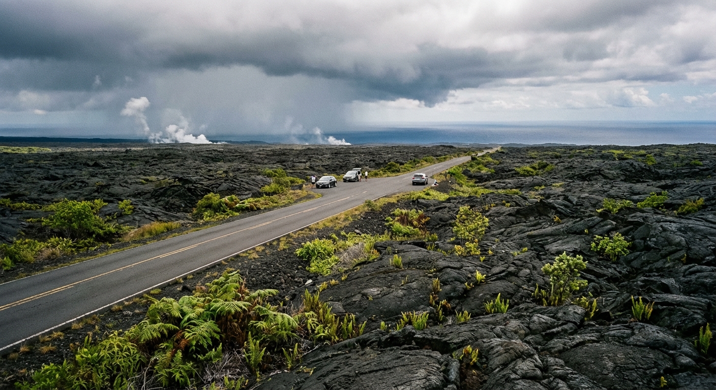
10) Chain of Craters Road (Hawaiʻi Volcanoes National Park, Hawaiʻi Island)
Distance: ~19 miles one-way (about 38 miles round-trip)
Estimated time: 2 to 4 hours with overlooks and optional short walks to viewpoints
Best season: Year-round; go early for clearer skies and calmer wind
Key overlooks and photo stops:
- Steam Vents roadside stop for surreal volcanic atmosphere
- Devastation Trail area for dramatic lava landscape (viewpoints nearby)
- Chain of Craters pullouts for layered lava flows and ocean views
- Hōlei Sea Arch viewpoint at the end of the road
Nearest gateway towns: Volcano Village (closest) or Hilo (more lodging and food)
11) Scenic Drive (Arches National Park, Utah)
Distance: ~18 miles one-way (visitor center area to Devils Garden trailhead parking)
Estimated time: 3 to 6 hours because you will stop constantly
Best season: March to May and September to November
Key overlooks and photo stops:
- Park Avenue Viewpoint for canyon-like walls
- Balanced Rock for a quick, iconic stop near the parking area
- The Windows Section for multiple arches with minimal walking required
- Delicate Arch Viewpoint (upper viewpoint is steeper, lower is easier)
Nearest gateway town: Moab for everything from tacos to nicer hotel beds
Maya tip: In shoulder seasons, sunrise drives feel almost private. In summer, plan for heat, crowds, and limited parking at popular viewpoints. Also, check whether timed entry is in effect before you roll up mid-morning.
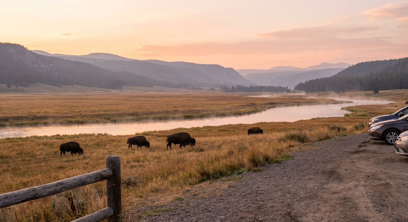
12) Lamar Valley (Yellowstone National Park, Wyoming)
Distance: ~30 miles one-way (Tower Junction to the Northeast Entrance at Silver Gate)
Estimated time: 2 to 6 hours depending on wildlife sightings and traffic stoppages
Best season: May to October; dawn and dusk are prime
Key overlooks and photo stops:
- Lamar Valley pullouts for bison and wide landscapes
- Soda Butte for geological interest right off the road
- Slough Creek area pullouts for wolf-watching culture (bring binoculars)
Nearest gateway towns: Gardiner, Montana (north entrance) or Cooke City and Silver Gate, Montana (near the northeast entrance)
How to choose the right drive for your day
- If you want maximum drama per mile: Going-to-the-Sun Road, Zion Canyon, Grand Canyon Desert View.
- If you love high elevation and big skies: Trail Ridge Road, Tioga Road, Crater Lake Rim Drive.
- If wildlife is the goal: Cades Cove (early), Lamar Valley (very early).
- If you are traveling with kids or grandparents: Badlands Loop Road and Acadia’s Park Loop are easy wins with frequent stops and minimal exertion.
If you tell me your travel month, where you are flying into, and whether you prefer mountains, desert, coast, or wildlife, I can help you pick the best option and map it into a one-day plan that ends in a great dinner town.