Big Bend National Park and Terlingua
Maya Lin
Maya Lin is a travel journalist and outdoor enthusiast who believes the best trips combine rugged adventures with urban comforts. After spending six years backpacking across four continents, she founded Trail & Town Guide to help fellow travelers navigate both hidden mountain passes and bustling city neighborhoods with confidence.
Big Bend feels like three parks stitched into one: a wild ribbon of the Rio Grande, a sun-baked desert of ocotillo and volcanic rock, and a surprising island of mountains that can be cool enough for a fleece even when the lowlands are sizzling. It is the kind of place where you hike a canyon in the morning, grab a good coffee in the afternoon (Terlingua is your best bet), and still make it back out for a night sky that looks freshly polished.
This guide is built for day hikers who want Big Bend’s greatest hits (Santa Elena Canyon, Emory Peak, the Window Trail, and Lost Mine), plus a Town Wander style bonus: Terlingua, the delightfully odd gateway “ghost town” where you can refuel, swap trail stories, and stay up too late stargazing.
Before you go: Big Bend basics
When to visit
Best seasons: Late October through April is prime for hiking, with cooler days and crisp nights. Spring brings wildflowers in good rain years and busy trailheads.
Summer reality check: May through September can be dangerously hot at lower elevations. If you visit in summer, plan sunrise starts, stick to shorter desert walks, and consider higher, shaded routes in the Chisos Mountains.
Fees and passes
Big Bend charges an entrance fee (per vehicle, per person, and annual pass options exist). Fees and payment methods can change, so check the current rates on the NPS site before you roll in. If you have an America the Beautiful pass, bring it.
Logistics you will actually feel on the ground
- Distances are big. Big Bend is remote and spread out. What looks close on a map can be an hour of driving.
- Fuel and food are limited. Fill up before you enter the park when possible. Fuel is often available at Panther Junction and Rio Grande Village, but hours and supply can vary. Check current status and do not rely on it as your only plan.
- Cell service is spotty to nonexistent. Download offline maps and do not rely on texting your way out of a wrong turn.
- Border context: The Rio Grande is the international boundary. Do not assume crossing into Mexico is a casual add-on. River crossings and ports of entry rules can change, and informal crossings are not permitted. Check current guidance from NPS and CBP.
Water, facilities, and the one number to remember
- NPS baseline: Plan on 1 gallon (4 liters) of water per person per day in this desert environment. For longer hikes or hot days, you may need more.
- Trail reality: Many trails have no reliable water. Bring what you need.
- Where you can usually refill: Visitor centers and developed areas like Chisos Basin and Rio Grande Village often have potable water and restrooms, but availability can vary seasonally. Treat water like a limited resource and top off whenever you see it.
What to pack (carry-on only friendly, desert edition)
- Sun protection: Wide-brim hat, sunglasses, sunscreen, and a light long-sleeve.
- Layers: The desert can roast you at noon and chill you at sunset. Chisos mornings can be cold in winter.
- Traction: Grippy shoes for rocky tread and steep switchbacks.
- Navigation: Offline map app plus a paper map as backup.
Slow-travel tip: Build in one “no big hike” day. Big Bend is a place where sunrise viewpoints, short nature walks, and a long lunch can be just as memorable as a summit.
The best Big Bend day hikes
These four hikes give you a full sampler platter: canyon drama, mountain air, desert color, and the park’s signature views. Conditions can change fast with weather, heat, and flood impacts, so check current alerts and trail updates with the National Park Service before heading out.
Hikes at a glance
Quick note: Times are typical ranges for day hikers, not speed records. Elevation gain is approximate.
| Hike | Round trip | Elevation gain | Typical time | Difficulty |
|---|---|---|---|---|
| Santa Elena Canyon Trail | ~1.7 mi (2.7 km) | ~100 to 200 ft | 1 to 2 hours | Easy to moderate (conditions dependent) |
| Lost Mine Trail | ~4.8 mi (7.7 km) | ~1,100 ft | 2.5 to 4 hours | Moderate |
| The Window Trail | ~5.6 mi (9.0 km) | ~800 to 1,000 ft | 3 to 5 hours | Moderate (feels harder on the way back) |
| Emory Peak (via Pinnacles) | ~10.5 mi (16.9 km) | ~2,400 to 2,600 ft | 6 to 9 hours | Strenuous (short summit scramble) |
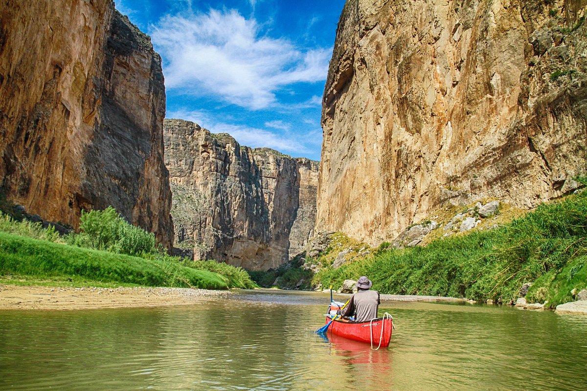
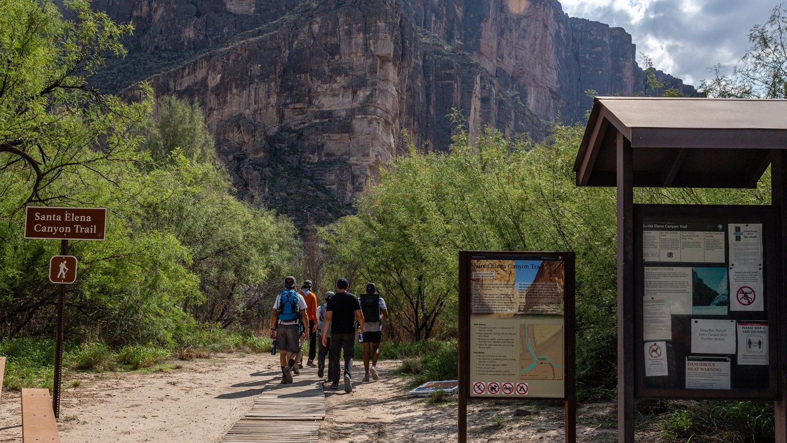
Santa Elena Canyon Trail
Why it is worth it: This is the postcard hike, and it earns the hype. You walk toward a narrow canyon where limestone walls rise dramatically above the Rio Grande.
Trailhead: Santa Elena Canyon parking area at the end of Ross Maxwell Scenic Drive.
- Best time: Morning for cooler temps, or late afternoon for glowing canyon walls.
- What to watch for: At times, water can cover the early section near the river. Depending on river level, it can range from a quick wade to impassable. Expect slippery rocks and intense sun in the open sections.
- Pair it with: A scenic drive on Ross Maxwell Scenic Drive with quick stops at overlooks.
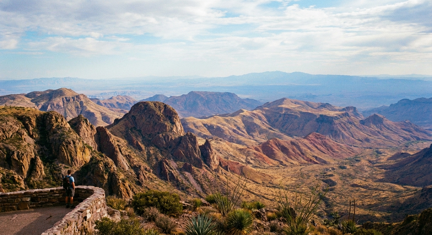
Lost Mine Trail
Why it is worth it: If you only have time for one Chisos hike, make it this one. The trail climbs steadily through oak and pine, delivering big views over Juniper Canyon and the surrounding desert. It is the sweet spot of effort to reward.
Trailhead: Lost Mine Trailhead along the Chisos Basin Road (limited parking).
- Best time: Early morning. Parking fills fast in peak season.
- What it feels like: A steady climb with frequent overlooks that make the uphill feel generous.
- Don’t skip: Lingering at the top viewpoint. It is one of the best places in the park to watch clouds cast moving shadows across the desert floor.
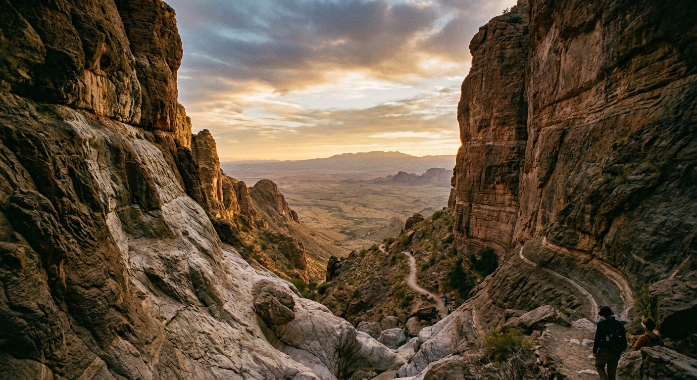
The Window Trail
Why it is worth it: The Window is Big Bend’s signature framed view, where the mountains open to a dramatic pour-off and a wide slice of desert beyond. The hike starts in the Chisos Basin and descends through a canyon-like drainage with lots of vegetation for the desert.
Trailhead: Chisos Basin trail network (signs for The Window Trail).
- Best time: Late afternoon is popular for sunset glow, but start early enough to hike back out comfortably.
- Know before you go: It is downhill on the way out, which means uphill on the way back. Save water for the return climb.
- Safety note: Avoid going beyond the signed areas near the pour-off. Flash floods can occur, even when it is not raining where you are.
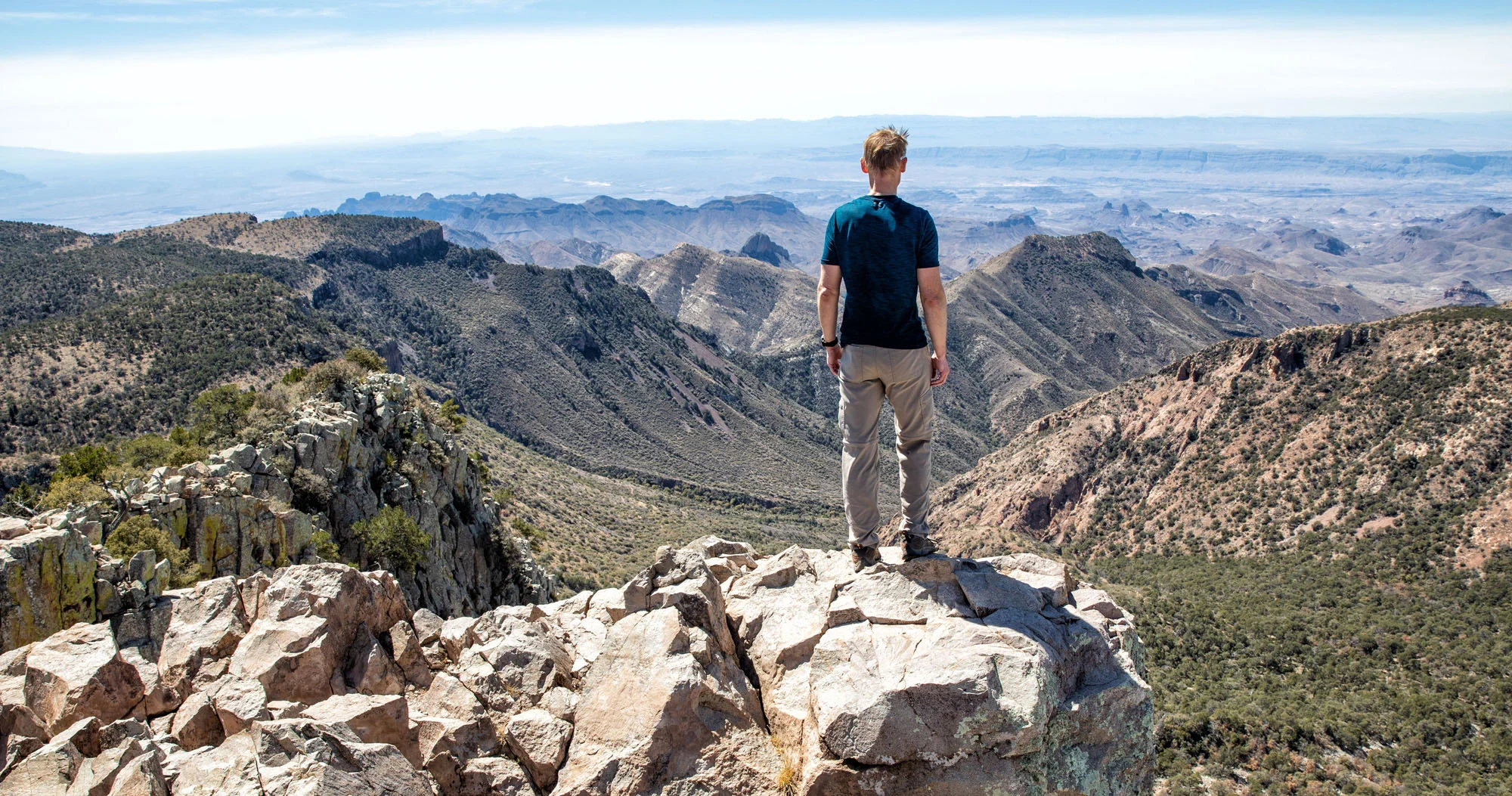
Emory Peak
Why it is worth it: Emory Peak is the high point in Big Bend, and the views remind you how massive and empty West Texas can feel. The route typically follows the Pinnacles Trail up through the Chisos, then tackles the final scramble to the summit.
Trailhead: Chisos Basin (most hikers start from the Basin and connect to Pinnacles).
- Best time: Start early to avoid midday heat on exposed sections and to beat afternoon winds.
- Difficulty reality: This is a big day with significant elevation gain. The final push includes a short scramble that can feel exposed for some hikers.
- Bring: Extra water, snacks, and a layer. The summit can be surprisingly cool and windy.
How to plan a 2 to 4 day trip
2 days
- Day 1: Santa Elena Canyon Trail plus Ross Maxwell Scenic Drive overlooks.
- Day 2: Lost Mine Trail at sunrise, then a relaxed afternoon in Terlingua for food and sunset.
3 days
- Day 1: Santa Elena Canyon and short stops along the drive.
- Day 2: The Window Trail, then Chisos Basin sunset.
- Day 3: Lost Mine Trail, coffee and wandering in Terlingua, stargazing at night.
4 days
- Day 1: Santa Elena Canyon.
- Day 2: Lost Mine Trail.
- Day 3: Emory Peak.
- Day 4: The Window Trail and an unhurried Terlingua evening.
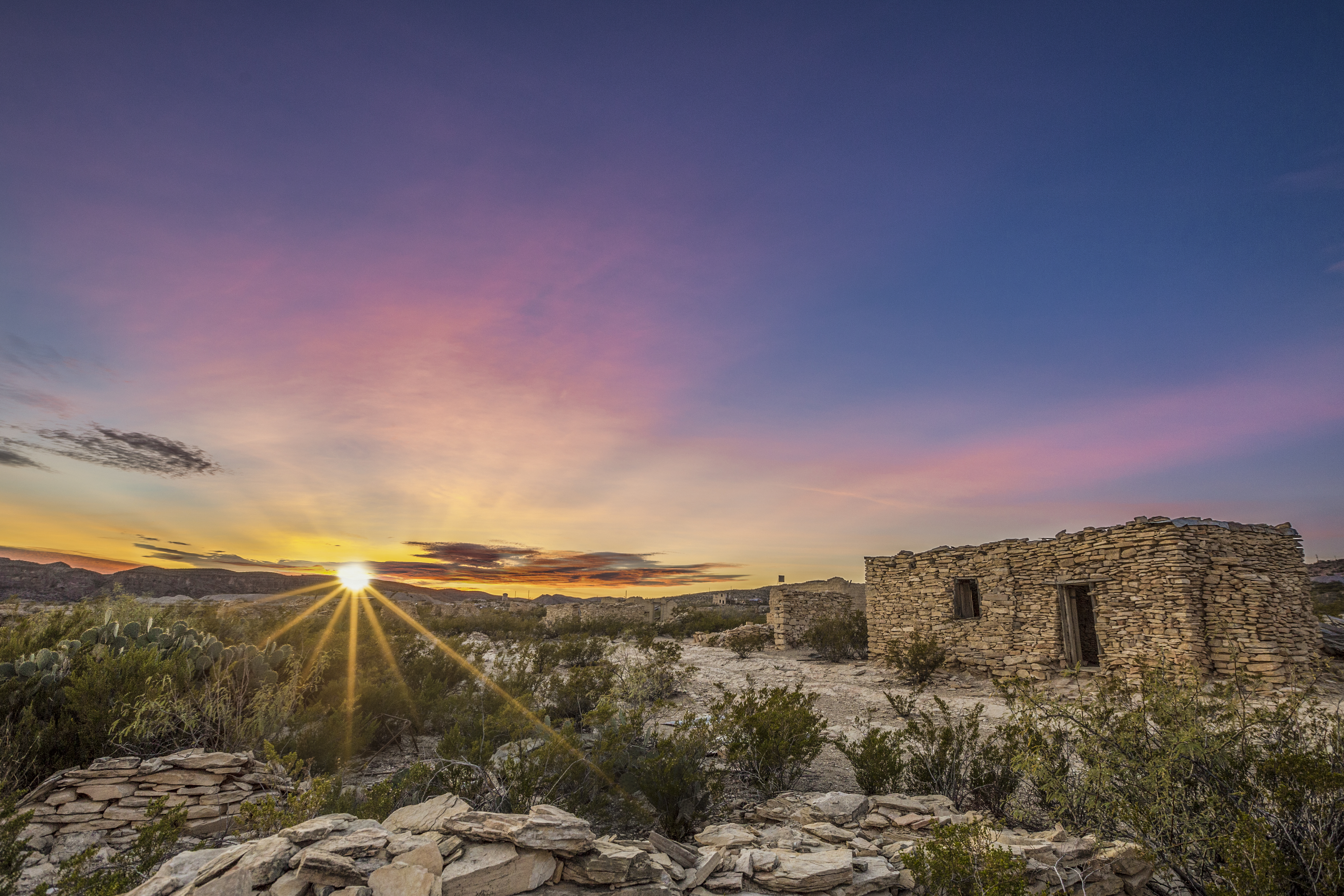
Terlingua
Terlingua is where Big Bend’s dust and drama meet a weirdly perfect brand of desert hospitality. Once a mining town, now a blend of scattered ghost-town ruins, artful rentals, and locals who have seen enough sunsets to talk about them like old friends. It is not polished, and that is the point.
What to do
- Wander the Terlingua Ghost Town: Rusted metal, crumbling stone, and unexpected art installations. Go in golden hour when everything looks cinematic.
- Chili culture: Terlingua is famous for its chili cookoffs. If your trip overlaps event dates, book lodging early and lean into the chaos.
- Stargazing: The Big Bend region is known for exceptionally dark skies and is part of a designated International Dark Sky area. Step away from porch lights, let your eyes adjust, and watch the Milky Way show up like a slow reveal.
- Live music and low-key nightlife: Expect patios, string lights, and conversations with strangers that turn into trail intel (conditions and tips).
Where to eat and drink
Options change seasonally, and hours can be desert-casual, so have a backup plan. In general, Terlingua is better at memorable vibes than fast service, which is a great trade when you are not in a rush.
- Breakfast: Look for simple tacos, burritos, and strong coffee before you drive back into the park.
- Post-hike dinner: Patio meals with sunset views are the move. Bring a light layer for breezy evenings.
- Grocery backup: Stock picnic supplies in advance when possible. Having trail lunches ready makes your park days smoother.
Where to stay
- Terlingua or Study Butte: Convenient for early starts and late-night stargazing with a bed nearby.
- Inside Big Bend: Great for minimizing driving, but book far ahead in peak season.
- Camping: The region is fantastic for camping, but wind and temperature swings are real. Stake things down and bring layers.
Desert safety and Leave No Trace
Big Bend’s beauty comes with sharp edges: heat, dehydration, flash floods, and remoteness. A few habits keep your trip fun instead of stressful.
- Start early: Sunrise hikes are cooler and quieter, and the light is unreal.
- Carry more water than you think you need: Use the 1 gallon (4 liters) per person per day baseline, and scale up for long hikes and heat. If you finish with extra, you did it right.
- Know heat illness signs: Headache, dizziness, nausea, cramps, confusion, and stopped sweating are all red flags. Rest, cool down, hydrate, and do not push on.
- Respect exposure: Desert trails can be full sun with very little shade. Midday heat is not just uncomfortable, it can be dangerous.
- Stay on trail: Desert soil and cryptobiotic crust can be fragile and slow to recover.
- Pack out everything: Including food scraps. In arid environments, “biodegradable” is not a quick process.
- Respect wildlife: Give animals space and never feed them.
Big Bend tip I learned the hard way: if you feel “a little” thirsty, you are already behind. Drink before you crave it, especially on exposed trails.
Quick FAQ
Is Big Bend good for first-time desert hikers?
Yes, if you plan for water, sun, and early starts. The classic day hikes are well-loved and fairly straightforward, but the environment is unforgiving if you underestimate heat.
Which hike should I prioritize if I only have one day?
For canyon drama, choose Santa Elena Canyon. For mountain views and cooler air, choose Lost Mine Trail.
Do I need a 4WD vehicle?
Not for the hikes in this guide. A standard vehicle can access Santa Elena, Chisos Basin trailheads, and the main park roads in normal conditions. If you want to explore rougher backroads, check current road conditions and consider high-clearance.
One last Town Wander nudge
Big Bend is not a place to race through. Give yourself at least one evening to do nothing but watch the light shift across the desert, then drive into Terlingua for a meal that tastes better because you earned it. Trails and towns, rugged and comfortable, all in one corner of Texas that still feels like the edge of the map.