Big Sur Day Hikes Along Highway 1
Maya Lin
Maya Lin is a travel journalist and outdoor enthusiast who believes the best trips combine rugged adventures with urban comforts. After spending six years backpacking across four continents, she founded Trail & Town Guide to help fellow travelers navigate both hidden mountain passes and bustling city neighborhoods with confidence.
Big Sur is the kind of coastline that makes you keep pulling over, even when you swear you are going to “just drive it.” The secret is building a day that actually welcomes those stops: a few bite-sized hikes with clear turnaround points, realistic elevation, and a plan for paid parking so you are not stress-scrolling in a roadside pullout while fog rolls in.
This guide runs south along Highway 1 from Carmel-by-the-Sea to San Simeon, stacking short hikes you can mix and match. Pick three if you want a relaxed coffee-and-viewpoints pace, or go for five or six if you are out early and daylight is generous.
Before you go: closures, miles, and how to not ruin your own day
1) Check Highway 1 conditions first
Big Sur is beautiful and unstable. Landslides, road repairs, and storm damage can close sections of Highway 1 with limited notice, especially south of Big Sur Village. Before you commit, check:
- Caltrans QuickMap for real-time closures and one-way traffic control on SR-1.
- California State Parks alerts for Point Lobos, Andrew Molera, Pfeiffer Big Sur, and Julia Pfeiffer Burns.
- Monterey County or park social channels for parking and access updates after storms.
If there is a closure south of Big Sur, you can still do a fantastic out-and-back day from Carmel to the parks north of the closure, then return the way you came.
2) Mileage reality: Carmel to San Simeon is not “close”
Carmel-by-the-Sea to San Simeon is about 80 miles (give or take, depending on your exact start and end points). In perfect conditions it is still slow, curvy driving, and with scenic pullouts, traffic, and photo gravity, drive time varies widely. Plan on 3 to 4 hours of driving for a through trip on a good day, plus hiking time and parking walks.
3) Gas is scarce and expensive
There are very few gas stations along Highway 1 through Big Sur, and prices are often shockingly high. Do yourself a favor and fuel up before you leave Carmel (or top off again near San Simeon) so you are not making itinerary decisions based on a blinking light.
4) Parking is the hidden itinerary killer
Along Big Sur, parking falls into three buckets:
- Paid day-use lots at state parks: reliable, but can fill quickly on weekends. Fees apply, and rates change, so check current pricing if you want certainty.
- Roadside pullouts: free, but limited and sometimes no-parking posted. Never stop where you are not fully out of the travel lane.
- Small trailhead pockets: easy on weekdays, competitive midday on weekends.
Bring a card and assume phone pay is an option in some places. Cash availability varies, and you do not want your day hinging on exact change.
5) What “short” still feels like in Big Sur
Even short trails can feel spicy here because of steep bluffs, sandy steps, and sun exposure. I include an “elevation honesty” note and a beginner-friendly turnaround point for every hike below. If you are new to hiking, that turnaround point is your permission slip to keep the day fun.
Quick pick: 3-stop day or 6-stop sampler
Option A: The classic 3-stop day
- Point Lobos: Cypress Grove and seaside views.
- Julia Pfeiffer Burns: McWay Falls overlook.
- Elephant seals near San Simeon: zero hiking, maximum payoff.
Option B: The full sampler (6 short hikes)
- Point Lobos: Cypress Grove Trail
- Garrapata State Park: coastal bluffs from the pullouts
- Pfeiffer Big Sur State Park: Pfeiffer Falls and Valley View
- Julia Pfeiffer Burns: McWay Falls Overlook
- San Simeon area: Elephant seal boardwalk
- Piedras Blancas: highway viewpoints or Light Station tour (when running)
Think of this as a menu, not a mandate. Big Sur rewards flexibility.
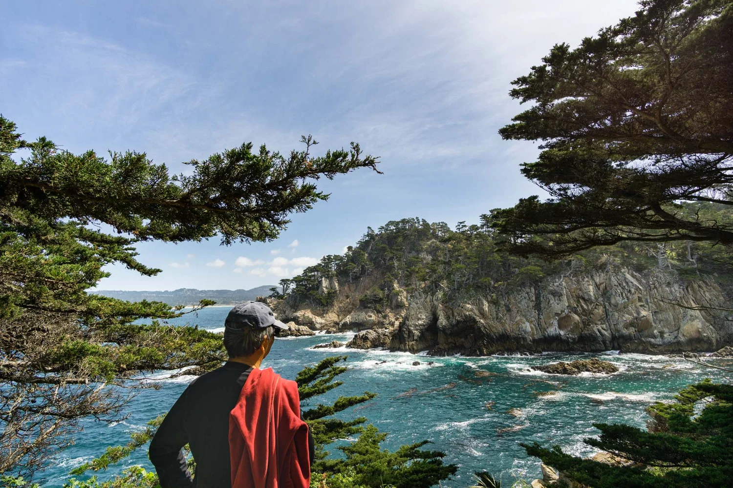
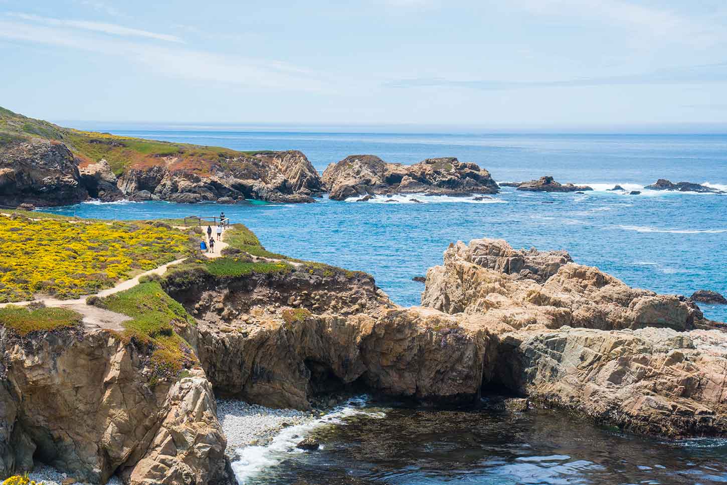
Hike 1: Point Lobos, Cypress Grove Trail
Best for: first-stop coastal drama, easy navigation, wildlife and wildflowers in season
- Start: Point Lobos State Natural Reserve (Carmel area, just north of Big Sur proper)
- Distance: about 0.8 to 1.5 miles depending on spurs
- Elevation honesty: mostly gentle, a few short rises and uneven coastal trail
- Time: 45 to 90 minutes
- Parking: paid entry and day-use lots, can fill early on weekends and holidays
If you only hike once today, make it here. Cypress Grove is the perfect soft opening act for a Highway 1 day: wind-shaped trees, coves that flash turquoise on clear days, and the kind of sea-air that makes you hungry for a second breakfast.
Beginner turnaround point: walk to the main coastal viewpoint in the grove, then return the way you came without adding spurs. If your group is feeling great, add a short loop along the shoreline.
Accessibility note: some sections are uneven and narrow. It is doable for many beginners, but not ideal for strollers or wheelchairs.
Hike 2: Garrapata State Park, coastal bluffs
Best for: a quick stretch break with huge views and minimal commitment
- Start: Garrapata State Park pullouts along Highway 1 (access is via multiple numbered turnouts)
- Distance: about 0.5 to 2 miles out-and-back depending on where you park
- Elevation honesty: mostly flat to rolling, but expect sandy patches and a few short climbs
- Time: 20 to 60 minutes
- Parking: roadside pullouts, limited space
Garrapata is a gift when you want coastline without the “big park” logistics. There is not one single signed “Bluff Trail” experience so much as a choose-your-own-adventure network of coastal paths that starts at the highway pullouts. The payoff comes fast: cliffs, surf, and the sense that the horizon is doing something dramatic just for you.
Beginner turnaround point: once you get a clean open view of the cliffs and can see waves breaking below, turn around. The best payoff is early.
Safety note: stay well back from edges. Big Sur bluff soil can crumble, and wind gusts are real.
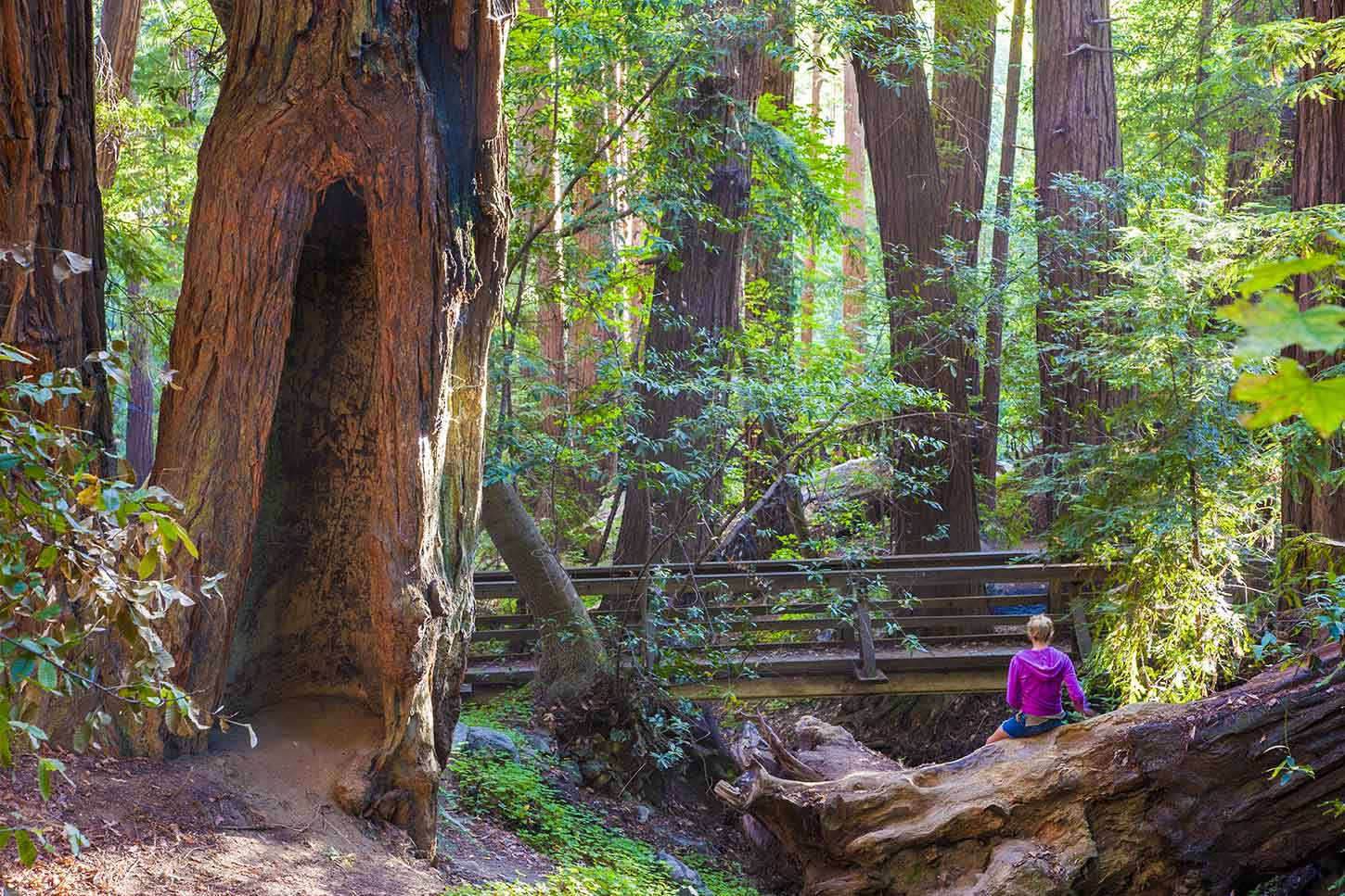
Hike 3: Pfeiffer Big Sur State Park, Pfeiffer Falls and Valley View
Best for: redwoods, shade, and a forest break between ocean viewpoints
- Start: Pfeiffer Big Sur State Park (near Big Sur Valley)
- Distance: roughly 2 miles round trip (varies by route)
- Elevation honesty: moderate. Expect steady climbing on the way out if you combine viewpoints
- Time: 60 to 90 minutes
- Parking: paid day-use parking inside the park
If the coast is the headline, Pfeiffer Big Sur is the cool, quiet side chapter. The redwoods feel like stepping into a cathedral, and the shade can be a relief when the highway is sun-baked.
Beginner turnaround point: hike to the falls viewpoint and head back. If you still have energy, continue to a valley view for a higher payoff, then return before your legs start bargaining.
Trail tip: after rain, sections can be muddy. Waterproof shoes are nice, but any grippy sole beats a slick sneaker.
Status note: trail routes and connectors sometimes change with storm damage and maintenance. Check posted notices at the kiosk or the park website before you commit to a specific loop.
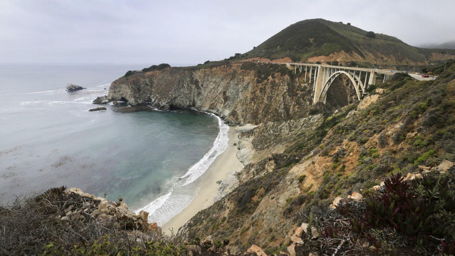
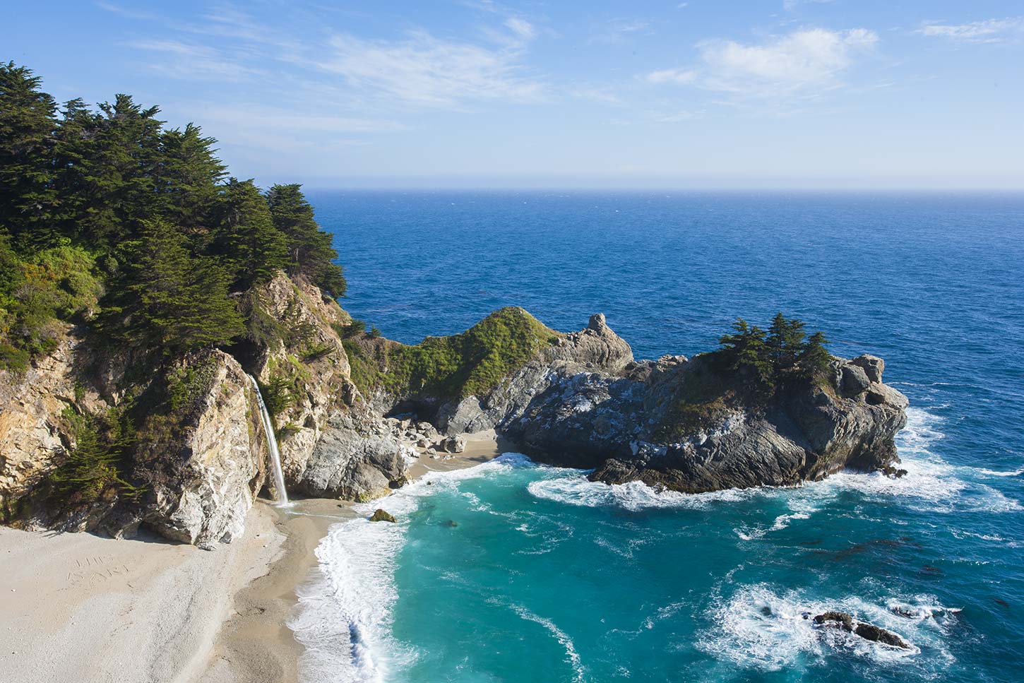
Hike 4: Julia Pfeiffer Burns, McWay Falls Overlook
Best for: the iconic Big Sur waterfall-to-beach moment
- Start: Julia Pfeiffer Burns State Park
- Distance: about 0.6 miles round trip
- Elevation honesty: easy to moderate. Short uphill grades and stairs, but very manageable
- Time: 20 to 40 minutes
- Parking: paid parking lot, often busy midday
This is the Big Sur postcard that actually lives up to it. You walk through coastal scrub, the sound of the ocean gets louder, and then the overlook opens to McWay Falls pouring onto a tucked-away cove.
Beginner turnaround point: the main overlook. Do not overcomplicate this one. Go, stare, breathe, take the photo, then get back on the road.
Good to know: access to the beach itself is typically not available. Treat this as a viewpoint hike.
Accessibility note: short and generally manageable, with a more built-out path than most bluff trails. Expect some grades.
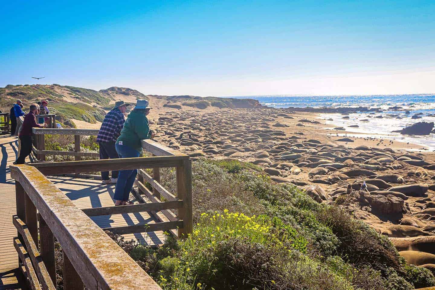
Hike 5: San Simeon area, Elephant seal boardwalk
Best for: a no-sweat stop that still feels wild
- Start: Elephant Seal Vista Point near San Simeon
- Distance: short boardwalk and viewpoint walk
- Elevation honesty: flat
- Time: 15 to 30 minutes
- Parking: dedicated lot, can be busy during peak viewing
After a day of cliffs and redwoods, this stop is pure coastal theater. Depending on season, you may see huge adults, restless juveniles, and plenty of dramatic lounging. Bring a layer. The wind here can cut through optimism.
Beginner turnaround point: any of the main viewing platforms. The goal is respectful watching, not distance.
Wildlife note: keep your distance and follow posted guidance. The seals are not props, and they move faster than they look when they decide to.
Accessibility note: one of the most accessible stops in this guide, with boardwalk-style viewpoints.
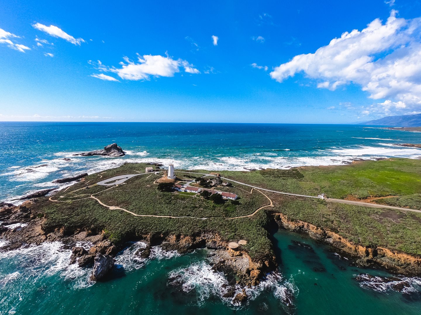
Hike 6: Piedras Blancas viewpoints and Light Station
Best for: lighthouse coastline vibes and a quieter end-of-day view
- Start: Piedras Blancas Light Station area near San Simeon
- Distance: short walks to highway viewpoints, longer walking only if you join a tour
- Elevation honesty: mostly flat
- Time: 15 to 45 minutes
- Parking: small lots and pullouts, follow posted rules
If timing lines up, this is a calm way to close your coastal day: open shoreline, sea spray, and that north-coast-of-SLO feeling where the landscape gets wider and quieter.
Important access note: the Light Station itself is typically only accessible via a guided tour with limited days and hours. If tours are not running, you can still enjoy the coastline from highway viewpoints and pullouts in the area, just do not expect to freely walk into the lighthouse complex.
Beginner turnaround point: the first safe viewpoint you reach. If wind is intense, call it early and head for a warm drink.
Paid parking and timing tips
When to start
- Weekends: aim to be at your first hike by 9:00 am if you want easier parking at Point Lobos and Julia Pfeiffer Burns.
- Weekdays: you have more breathing room, but midday can still feel busy in summer.
When paying is worth it
- Point Lobos: the reserve is compact and gorgeous. Paying gets you safe access and straightforward trails.
- Julia Pfeiffer Burns: the McWay Falls overlook is short and iconic, and the lot saves you from risky roadside scrambling.
- Pfeiffer Big Sur State Park: best choice if you want redwoods without hunting for unofficial pullouts.
Bring these, even for short hikes
- Water, even when it is foggy. Coastal hikes dehydrate quietly.
- Wind layer or light rain shell. Big Sur weather changes fast.
- Sun protection. Fog burns off, and exposed bluffs do not play around.
- Offline maps. Cell service is patchy.
Bathrooms and water
Do not assume the next stop will have restrooms or a working water spigot. State parks usually have facilities near main lots, but in between parks it can be sparse. Use the bathroom when you see one, even if you feel fine.
Beginner pacing: pick your turnaround
If you are new to hiking, your best tool is the turnaround point. Here is a simple rule that keeps Big Sur fun:
- Turn around when you still feel good. The steepest part is often on the way back, even if it did not feel steep going out.
- Stop at the first big payoff view. On coastal trails, the “next viewpoint” is usually similar, not better.
- Watch your footing before your photos. A great picture is not worth a slipped step near a bluff edge.
If you want to stack multiple stops, keep hikes short early and save one slightly longer walk for the middle of the day when your body is warmed up and your schedule is clear.
Food and coffee strategy
Highway 1 is not a place to gamble on finding exactly what you want at exactly the moment you want it. Pack snacks and plan one deliberate stop for something warm.
- Pack: a sandwich, salty snacks, and fruit. You will be grateful later.
- Coffee mindset: grab a solid cup before you leave Carmel, then treat any later caffeine as a bonus rather than a guarantee.
- Leave no trace: bring a small bag for wrappers and peels. Turnouts are not trash cans.
Season note: summer can mean heavy morning fog and bright afternoons. Spring can deliver wildflowers. Elephant seal viewing is best in winter and early spring, but there is usually something happening year-round.
Sample itinerary: Carmel to San Simeon (4 hikes + wildlife)
- 8:30 am: arrive at Point Lobos, hike Cypress Grove (60 to 90 minutes)
- 10:30 am: quick Garrapata coastal bluff walk (20 to 40 minutes)
- 12:30 pm: lunch picnic and redwoods at Pfeiffer Big Sur State Park (60 to 90 minutes walking total)
- 3:00 pm: McWay Falls overlook at Julia Pfeiffer Burns (20 to 40 minutes)
- 5:00 pm: elephant seals near San Simeon (20 minutes)
Build in extra time for viewpoint pullouts. Big Sur will take it anyway.
Drive smart: safety reminders
- Only pull over where it is legal and safe, fully off the roadway.
- Do not cross traffic impulsively. Use designated lots and crossings when available.
- Fog is not just aesthetic. Slow down, use headlights, and keep distance.
- Respect closures. They exist because the road is unstable, not because someone wants to ruin your day.
One last thing: slow down
The best Big Sur days feel like a string of small, satisfying chapters: a redwood detour, a cliffside breath, a waterfall glimpse, a windy wildlife stop. You do not need a marathon hike to earn the views here. You just need a good plan, a warm layer, and the willingness to stop when something beautiful grabs you.
If you only remember one tip, make it this: pick your turnarounds ahead of time, then enjoy the freedom of not pushing past them.