Cedar Breaks: Rim Walks and a Bryce to Zion Stop
Maya Lin
Maya Lin is a travel journalist and outdoor enthusiast who believes the best trips combine rugged adventures with urban comforts. After spending six years backpacking across four continents, she founded Trail & Town Guide to help fellow travelers navigate both hidden mountain passes and bustling city neighborhoods with confidence.
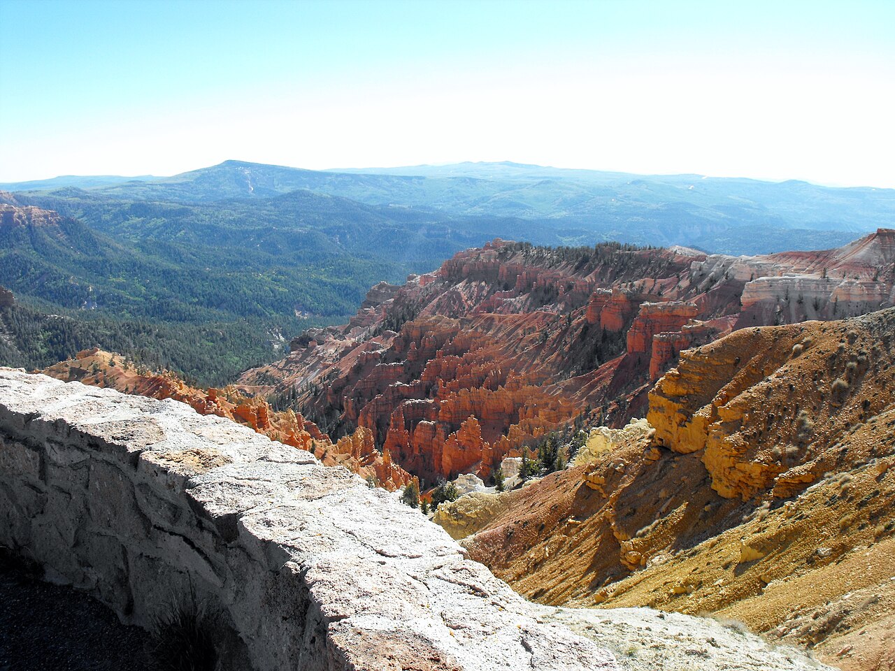
Cedar Breaks National Monument is the high-country cousin of Bryce Canyon, perched around 10,000 feet on the Markagunt Plateau and carved into a red-orange amphitheater that looks almost too dramatic to be real. The best part is you do not need a full day or a headlamp start. If you are road-tripping the Bryce to Zion corridor, Cedar Breaks makes a clean 2 to 3 hour stop that delivers big views with short, rim-hugging walks (mostly flat to gently rolling).
This page is designed to complement your Bryce day hikes, not duplicate them. Think: fewer switchbacks, more “pull over, breathe in the alpine air, and let your camera do the heavy lifting.”
Quick season note: Cedar Breaks has a short main season. The road and visitor services are most reliable in late spring through early fall, and visitor center hours vary by season. Check the official NPS site before you go.
Know before you go: UT-148 is seasonal
The biggest Cedar Breaks surprise is not the altitude. It is access. Utah State Route 148 crosses the monument and is typically closed in winter due to heavy snow. Even shoulder seasons can be unpredictable.
What the closure means
- Summer and early fall are the easiest: the scenic drive is open, viewpoints are accessible, and the rim walks are straightforward.
- Late fall through spring often brings road closures (commonly sometime in late Oct/Nov through May/June, depending on snow): you may not be able to drive through the monument on UT-148.
- Access depends on your approach. When UT-148 is closed, it can limit or block vehicle access to the main overlooks and visitor area, depending on which side you are coming from and what is open that day.
- Always verify conditions before you build your day around it. Check the official NPS Cedar Breaks road status and current conditions, and also look at UDOT updates for UT-148.
If you are routing between Bryce and Zion, treat Cedar Breaks as a weather-dependent bonus in the colder months. In summer, it is one of the most reliable high-elevation scenic stops in southern Utah.
The easiest 2 to 3 hour plan
If you have limited time, you want two things: a sweeping amphitheater view and at least one “stand on the edge of the world” moment. Here is the simplest way to get both without turning this into a long hike day.
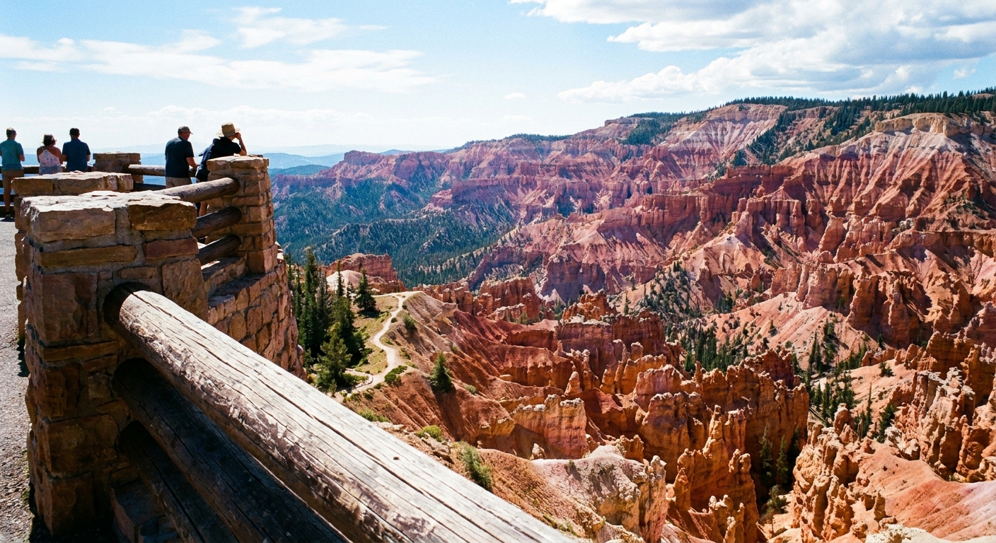
Stop 1: Point Supreme Overlook
This is the classic first look. From the rim, you get an immediate sense of scale: the amphitheater drops away into layers of iron-rich reds, oranges, and purples, ringed by dark green spruce and fir. If you arrive in the morning, the light often hits the formations with extra contrast.
Accessibility note: Point Supreme has paved paths and accessible viewing areas, making it a great option if someone in your group wants the big view without the trail.
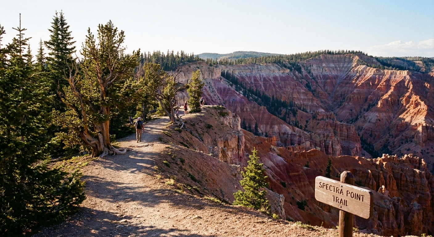
Stop 2: Spectra Point (short walk, big payoff)
Spectra Point is the quick, confidence-boosting walk I recommend when you want to feel like you did something beyond viewpoints. The trail is short and generally easy, and it leads you along the rim to a higher perspective where the amphitheater spreads out in a wide arc.
- Distance and time: about 1 mile round-trip, roughly 30 to 45 minutes at an easy pace (longer if you linger, which you should).
- Why it is worth your time: Elevated rim vantage, great photos, and a satisfying “we got out of the car” stretch.
- What it feels like: Cool air, pine scent, and that slightly lightheaded reminder that you are above 10,000 feet.
Take it slow if you have been at lower elevations all week. Cedar Breaks is not the place to prove cardio dominance.
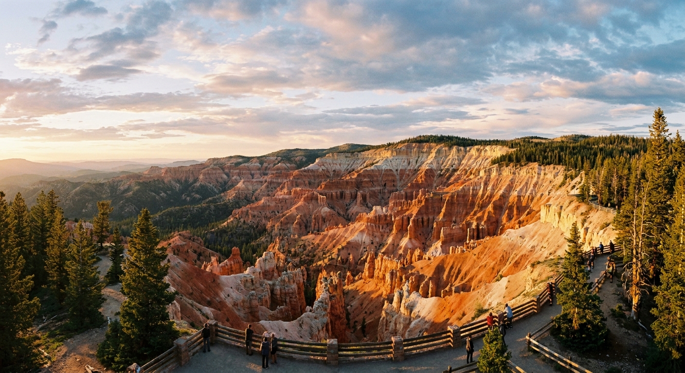
Stop 3: Sunset View (easy and dramatic)
If you want one more big “wow” without committing to a longer hike, make your next stop a drive-up overlook like Sunset View. It is quick, it is scenic, and it gives you a slightly different angle on the amphitheater so the place feels bigger than your first look.
- Why it works: Fast access, strong payoff, and a different rim perspective than Point Supreme.
- Best for: Late-day light, cloud drama, and anyone who wants another huge view with minimal walking.
- Walking note: Expect a short, paved path from the parking area to the viewpoint.
Optional: Ramparts Overlook (longer hike)
Ramparts Overlook is incredible, but it is not a drive-up stop. It is the turnaround point of the Ramparts Trail, commonly described as about 2 miles one-way (around 4 miles round-trip) from the Point Supreme area, passing the Spectra Point spur along the way. If you have extra time, stable weather, and the legs for it, this is the rim walk that feels like you earned your views.
- Plan for: A moderate outing at altitude, with more time on foot and fewer crowds once you get beyond the near-rim viewpoints.
- Do it when: The sky looks calm and you have enough daylight to walk unhurried.
- Reality check: Trail distances and conditions can change with maintenance and snow. Confirm current details with NPS if this hike is a priority.
Wildflowers: a short window
Cedar Breaks is famous for its summer wildflowers, and this is one of the most distinct reasons to add it even if you already have Bryce on your itinerary. Because of the altitude, bloom time tends to arrive later than you might expect in southern Utah.
Typical timing
- Peak wildflowers: typically July to August (sometimes into early September), varying year to year with snowpack and spring temperatures.
- What you will see: meadows and roadside patches lit up with color, especially around the rim area and along short trails.
If wildflowers are your priority, aim for a mid-summer visit and build a little flexibility into your plan. Even a week can make a difference at this elevation.
Altitude and weather: two gotchas
Cedar Breaks is not technical, but it is high. And summer afternoons can turn stormy fast. A few practical precautions will keep your stop fun, not frantic.
Altitude tips
- Hydrate earlier than you think you need to. Dry air plus elevation is a sneaky combo.
- Take the first 20 minutes slowly. If you feel winded walking from the parking lot, that is normal.
- Pack layers. Even on a hot desert road trip, Cedar Breaks can feel genuinely chilly.
Lightning and storms
High ridgelines attract lightning. If you see building thunderheads or hear thunder, treat that as your cue to leave exposed overlooks and return to your vehicle. The rim is spectacular, but it is not the place to wait out a storm.
- Best strategy: visit earlier in the day, especially during monsoon season when afternoon storms are more common.
- Bring: a light rain shell, and keep an eye on the sky even if the forecast looks calm.
How to fit Cedar Breaks into a Bryce to Zion route
If your trip is built around the Bryce to Zion corridor, you may be thinking: “Do I really need another amphitheater view after Bryce?” Here is the honest answer: Cedar Breaks feels different because it is alpine. The air is cooler, the forest is thicker, and the rim experience is more relaxed and less hike-centric.
Two easy ways to use it well
- Option A: The scenic palate cleanser. Do Bryce hikes earlier in your trip, then use Cedar Breaks as a later-day viewpoint stop when you want beauty without another long trail.
- Option B: The weather pivot. If Bryce is hot and exposed mid-day, Cedar Breaks can be a cooler break, assuming UT-148 is open and storms are not building.
Routing note: Cedar Breaks pairs naturally with Highway 14 and Scenic Byway 143 (Patchwork Parkway), which is one of the prettiest drives in this part of Utah. Most road-trippers connect via Cedar City and UT-14, then up to UT-148 when it is open. Another common link is via Brian Head and UT-143. The key is to keep it short. This is a rim-walk and viewpoints stop, not a full day of hoodoo mileage.
Logistics: fees and quick packing list
Entrance and basics
Cedar Breaks is a national monument with an entrance fee. If you have an America the Beautiful pass, it is typically accepted. Facilities are limited compared with a major national park, so plan like you are doing a scenic stop, not a full-service town day.
Services note: Restrooms are typically available around the visitor center area and at some main stops in season, but do not count on food, gas, or strong cell service up top. For supplies, think Cedar City, Brian Head, or wherever you last had a real grocery aisle.
Carry-on-only packing list
- Water and a snack, even if you just ate in town
- Warm layer or light puffy, plus a rain shell in summer
- Sunscreen and sunglasses, because altitude sun is intense
- Good walking shoes for short rim trails
- Offline map or downloaded directions in case service is spotty
If you have time for one extra comfort item, make it a thermos of coffee from your last good stop. Sipping something warm on a 10,000-foot rim is an underrated kind of luxury.
Sample timing: simple 3 hours
- 0:00 to 0:20 Arrive, acclimate, quick photos at Point Supreme Overlook
- 0:20 to 1:20 Walk to Spectra Point and linger at the viewpoint
- 1:20 to 2:10 Drive to Sunset View, short walk, more photos
- 2:10 to 3:00 Scenic drive between overlooks, quick wildflower pullouts, and a weather check before you continue
If storms are building, flip the plan: do the furthest overlook first, then work your way back toward the visitor area so you can exit quickly.
Leave it better
High-elevation ecosystems recover slowly. The easiest way to travel responsibly at Cedar Breaks is also the simplest: stay on established trails, do not pick wildflowers, and pack out every scrap of trash, including fruit peels and tissues.
- Use existing pullouts instead of creating new roadside parking spots.
- Keep a little distance from the rim edge, especially on windy days.
- If you are visiting during peak bloom, be extra mindful of meadow edges and trail widening.
Cedar Breaks is proof that you can get a huge experience in a short stop. Keep it light, keep it safe, and let the rim do what it does best: make you feel very small in the best possible way.