Columbia Icefield Parkway: Best Short Stops and Walks
Maya Lin
Maya Lin is a travel journalist and outdoor enthusiast who believes the best trips combine rugged adventures with urban comforts. After spending six years backpacking across four continents, she founded Trail & Town Guide to help fellow travelers navigate both hidden mountain passes and bustling city neighborhoods with confidence.
There are road trips, and then there is the Columbia Icefield Parkway. The 230 km stretch of Highway 93 North between Lake Louise and Jasper serves up glacier views, turquoise lakes, and big-valley drama so frequently it almost feels unfair to the rest of the planet.
This guide sticks to what the Parkway does best: quick, high-reward stops and sub-hour walks you can weave into a one-day drive or a slower two-day cruise. I will also flag the reality-check stuff people forget to tell you, like where crowds stack up, what tends to close in winter, and how to stay smart in serious wildlife country.
Before you go
Time it like a local
- Best window: Start early. If you can roll out of Lake Louise by 7 to 8 am, you will beat the worst of the parking hunts at the busiest viewpoints and the midday tour buses at the Icefield.
- Golden hour bonus: Late afternoon light can be incredible at Waterfowl Lakes and Athabasca Falls, but you trade that for more wildlife on the road and fewer services open.
Season and access basics
- Easiest season: Late spring through early fall is the sweet spot for maximum access to viewpoints, trailheads, and services.
- Any-month reality: Snow, smoke, rain, and temporary closures can happen in any month. Check conditions right before you go.
What to pack for short walks
- Layers and a rain shell. Weather changes fast in the Bow and Athabasca valleys.
- Sturdy shoes. Many “short” paths are rocky or slick near water.
- Bear spray, accessible and you know how to use it.
- A thermos or refillable bottle. Services between Lake Louise and Jasper are limited.
Park pass and road basics
You need a valid Parks Canada pass for Banff and Jasper National Parks. Cell coverage is inconsistent. Download offline maps and do not count on streaming your way through the day.
Fuel and facilities
Here is the big one: Saskatchewan River Crossing is the most reliable fuel stop and the primary services stop along the Parkway itself. Top up before you leave Lake Louise, and treat Saskatchewan River Crossing as your main refuel and bathroom plan, not a “maybe if we feel like it.”
Quick note: Hours and availability can be seasonal or operational. Food options are limited and can close early, so bring snacks and do not assume you can grab a full meal on impulse.
Wildlife reality check
This corridor is prime habitat for bears, elk, mountain goats, bighorn sheep, and wolves. Stay in your vehicle during wildlife jams, never feed animals, and give them space. Parks Canada guidance is to stay at least 30 m from elk, sheep, and goats, and 100 m from bears and wolves.
Stops: Lake Louise to Columbia Icefield
Stops are listed in driving order heading north toward Jasper. Times are for the walking portion, not counting lingering for photos or snack breaks.
Hector Lake viewpoint (quick pullout)
Time: 5 to 10 minutes
Why stop: A calm, wide lake with big peaks behind it, often with morning reflections.
Crowds: Usually manageable, but pullouts can fill in late morning.
Crowfoot Glacier viewpoint (quick pullout)
Time: 5 to 10 minutes
Why stop: A classic roadside glacier view that helps you visualize how much the ice has changed over time.
Tip: Bring binoculars if you have them. The glacier sits across the valley.
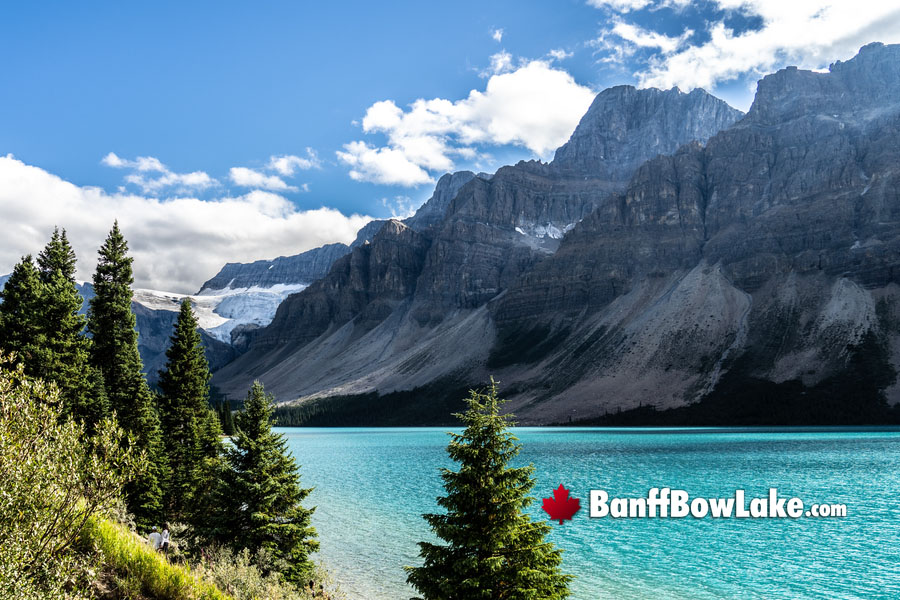
Bow Lake and Num-Ti-Jah Lodge (short stroll)
Time: 15 to 30 minutes
Why stop: One of the most beautiful “step out of the car and instantly feel like you are in a postcard” lakes on the route. Wander the lakeshore near the lodge for easy views.
Good to know: Wind picks up mid-day, which can flatten those mirror reflections.
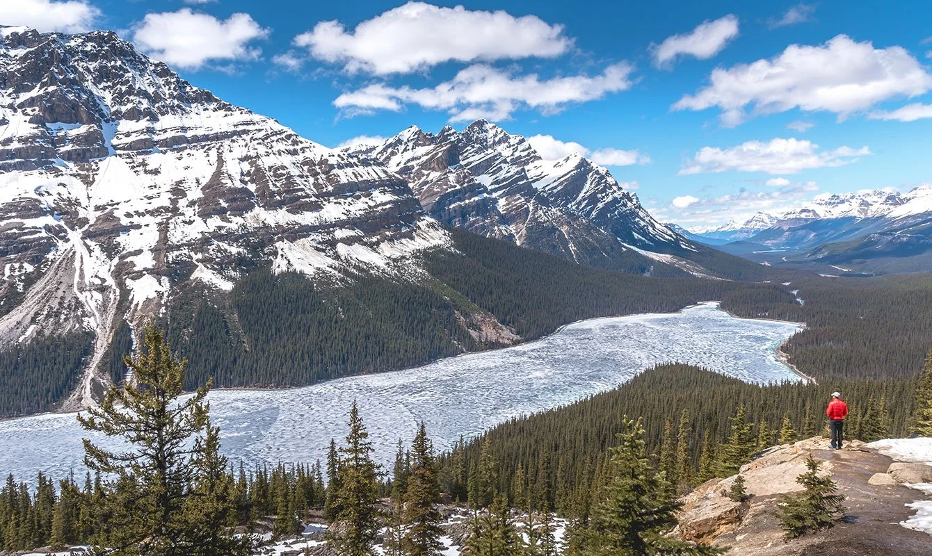
Peyto Lake viewpoint (short uphill walk)
Time: 25 to 45 minutes round trip
Why stop: That unreal, bright-blue lake shape you have definitely seen online.
The walk: A well-maintained uphill path from the parking area to the viewing platform.
Crowds: One of the busiest stops on the entire Parkway. Arrive before 9 am for a calmer experience.
Seasonal note: The access road and viewpoint area can close or be limited in winter due to avalanche conditions and maintenance.
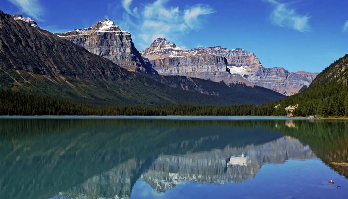
Waterfowl Lakes (quick pullout or short wander)
Time: 10 to 25 minutes
Why stop: Layered mountain views with long, open sightlines. This is a strong “stretch your legs” stop that rarely feels as chaotic as Peyto.
Wildlife note: This area can be active for bears in summer. Stay alert on the edges of the parking areas and any brushy shoreline paths.
Saskatchewan River Crossing (fuel and reset)
Time: 10 to 30 minutes
Why stop: This is the practical heartbeat of the Parkway: the main and most reliable fuel stop, plus the most dependable place to use a bathroom, grab food, and regroup.
Tip: Even if you do not feel empty yet, topping up here keeps the rest of the day stress-free.
Planning note: Hours can be limited or seasonal. If you are traveling early or late in the day, keep your own snacks and water as backup.
Weeping Wall (very quick stop)
Time: 5 to 10 minutes
Why stop: A dramatic cliff where water sheets down the rock in warmer months and freezes into blue-white curtains in winter.
Big Bend viewpoint (quick stop)
Time: 10 minutes
Why stop: A sweeping view where the road curves and the valley opens up toward the Columbia Icefield region. It feels like the Parkway turning up the volume.
Parker Ridge (sub-hour option if you move fast)
Time: 45 to 60 minutes round trip if you are brisk
Why stop: One of the best short hikes for a “wow” payoff: big views toward the Saskatchewan Glacier.
The walk: A steady uphill climb on a well-used trail. You will feel the elevation, even though the distance is modest.
Seasonal note: Snow can linger well into early summer. In shoulder season, traction can make this safer and more pleasant.
Columbia Icefield: glacier viewpoints (short, windy walks)
Time: 15 to 45 minutes depending on how far you wander
Why stop: The scale is hard to grasp until you are there. Even if you skip the paid attractions, the roadside views are worth your time.
Crowds: Heavy mid-day in summer. If this is a must, aim early or late.
Important: Do not walk onto the glacier without proper gear and a professional guide. Crevasses are real, and they are not always obvious.
Athabasca Glacier toe viewpoint (short walk)
Time: 30 to 60 minutes round trip, depending on viewpoint and conditions
Why stop: The most direct, educational look at the Athabasca Glacier. The terrain is rocky and can be slick with meltwater.
Safety: Stay behind barriers and signage. The glacier area changes constantly.
Stops: Columbia Icefield to Jasper
Tangle Falls (very quick stop)
Time: 10 to 20 minutes
Why stop: A multi-tier waterfall you can see from the road. If you need a “stretch, sip water, take two photos” break, this is ideal.
Stutfield Glacier viewpoint (quick pullout)
Time: 5 to 10 minutes
Why stop: A classic roadside glacier scene without the same crowd pressure as the Icefield center.
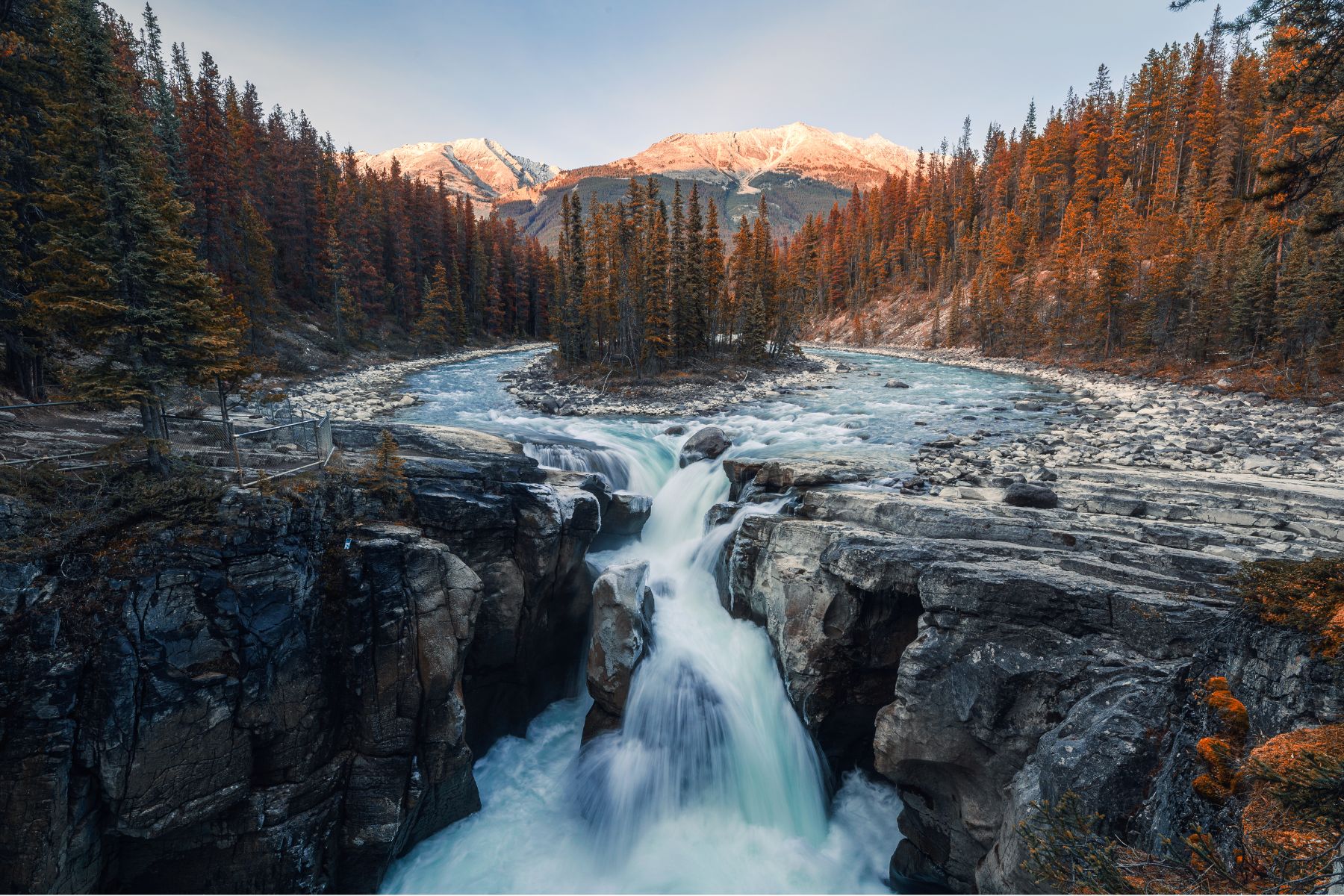
Sunwapta Falls (easy viewpoint walk)
Time: 15 to 30 minutes
Why stop: Powerful falls right near the parking area, with viewing platforms that make it accessible and quick.
Tip: Mist and cool air feel amazing on hot afternoons. On chilly days, pack an extra layer.
Goat Lick (wildlife viewing pullout)
Time: 5 to 20 minutes
Why stop: Mountain goats sometimes visit the mineral lick across the highway. Even when the goats do not show, the cliff-and-river scenery is gorgeous.
Etiquette: Stay in designated areas. Do not cross the road impulsively. Traffic moves fast here.
Athabasca Falls (short walk, big payoff)
Time: 30 to 60 minutes
Why stop: Not the tallest waterfall, but one of the most forceful. The falls carve through a narrow gorge that makes everything feel loud and alive.
Crowds: Very popular. Go early morning or later afternoon if you can.
Valley of the Five Lakes (choose-your-own sub-hour loop)
Time: 35 to 60 minutes for a partial loop
Why stop: A forest-and-lake walk that feels like a palate cleanser after big roadside views. You can do the full loop at a relaxed pace, or simply go out to one or two lakes and turn back to keep it under an hour.
Tip: This is a nice option if the Parkway viewpoints are packed and you want a quieter experience close to Jasper.
Wabasso Lake trailhead (short out-and-back)
Time: 30 to 60 minutes out-and-back toward the lake
Why stop: Less famous than other stops, which can mean fewer people. You can walk in for a taste of the area without committing to a long hike.
Seasonal note: Wet sections are common after rain or snowmelt. Waterproof shoes help.
Closures and winter notes
The Parkway is famous for summer road trips, but it is also a legitimate winter corridor with avalanche terrain and fast-changing conditions.
- Winter driving: Expect icy stretches, reduced daylight, and sudden weather shifts. Carry winter tires, extra layers, and snacks.
- Trail access: Viewpoints like Peyto Lake and higher-elevation trailheads can be limited or closed due to avalanche hazard and plowing priorities.
- Facilities: Bathrooms and services may be seasonal. Plan your stops accordingly, and do not assume you can “just fuel up later.” Saskatchewan River Crossing remains the key planning stop on the route.
For the most accurate, day-of info, check Parks Canada trail reports and highway conditions before you leave cell service.
Build your day
If you only have one day
- Morning: Crowfoot Glacier (quick) + Bow Lake (stroll) + Peyto Lake (early)
- Midday: Waterfowl Lakes + Saskatchewan River Crossing (fuel and reset)
- Afternoon: Weeping Wall + Big Bend + Parker Ridge (if conditions are good)
- Late day: Columbia Icefield viewpoints + Tangle Falls + Stutfield Glacier + Sunwapta Falls or Athabasca Falls on the way into Jasper
If you have two days and want it calmer
- Day 1: Lake Louise to Columbia Icefield, with more time at Bow Lake, Waterfowl Lakes, and a short hike like Parker Ridge if conditions are good. Refuel at Saskatchewan River Crossing on the way north.
- Day 2: Icefield area to Jasper, focusing on Tangle Falls, Stutfield Glacier, Sunwapta Falls, Goat Lick, and Athabasca Falls, then an easy lake walk near Jasper.
If you can swing it, two days turns the Parkway from a checklist into a mood. You will notice the small stuff, like how the air smells different near the ice and how quickly the light changes in the valleys.
Low-stress, leave-no-trace habits
- Stay on trail at viewpoints and along shorelines. Alpine vegetation is fragile and slow to recover.
- Pack out everything, including food scraps. Wildlife learns fast.
- Use pullouts correctly and do not stop on the roadway for photos. The best souvenir is everyone getting home safely.
- Make room for others at crowded platforms. Take your photo, take a breath, then rotate out.
FAQ
How long does it take to drive from Lake Louise to Jasper without stops?
Roughly 3.5 to 4.5 hours in good conditions. With scenic stops, most people take 7 to 10 hours. Construction, wildlife slowdowns, and weather can stretch the baseline drive time, so build in buffer.
Are the short walks family-friendly?
Many are, especially Bow Lake shoreline, Sunwapta Falls, and Athabasca Falls viewpoints. Always watch for steep edges near water and keep kids close at wildlife pullouts.
What is the single best short stop if I am short on time?
If you can only do one: Peyto Lake for iconic color and shape, or Athabasca Falls for pure energy and easy access. If crowds stress you out, choose Bow Lake instead and linger on the shore.