Coyote Gulch Access and Slot Canyon Basics
Maya Lin
Maya Lin is a travel journalist and outdoor enthusiast who believes the best trips combine rugged adventures with urban comforts. After spending six years backpacking across four continents, she founded Trail & Town Guide to help fellow travelers navigate both hidden mountain passes and bustling city neighborhoods with confidence.
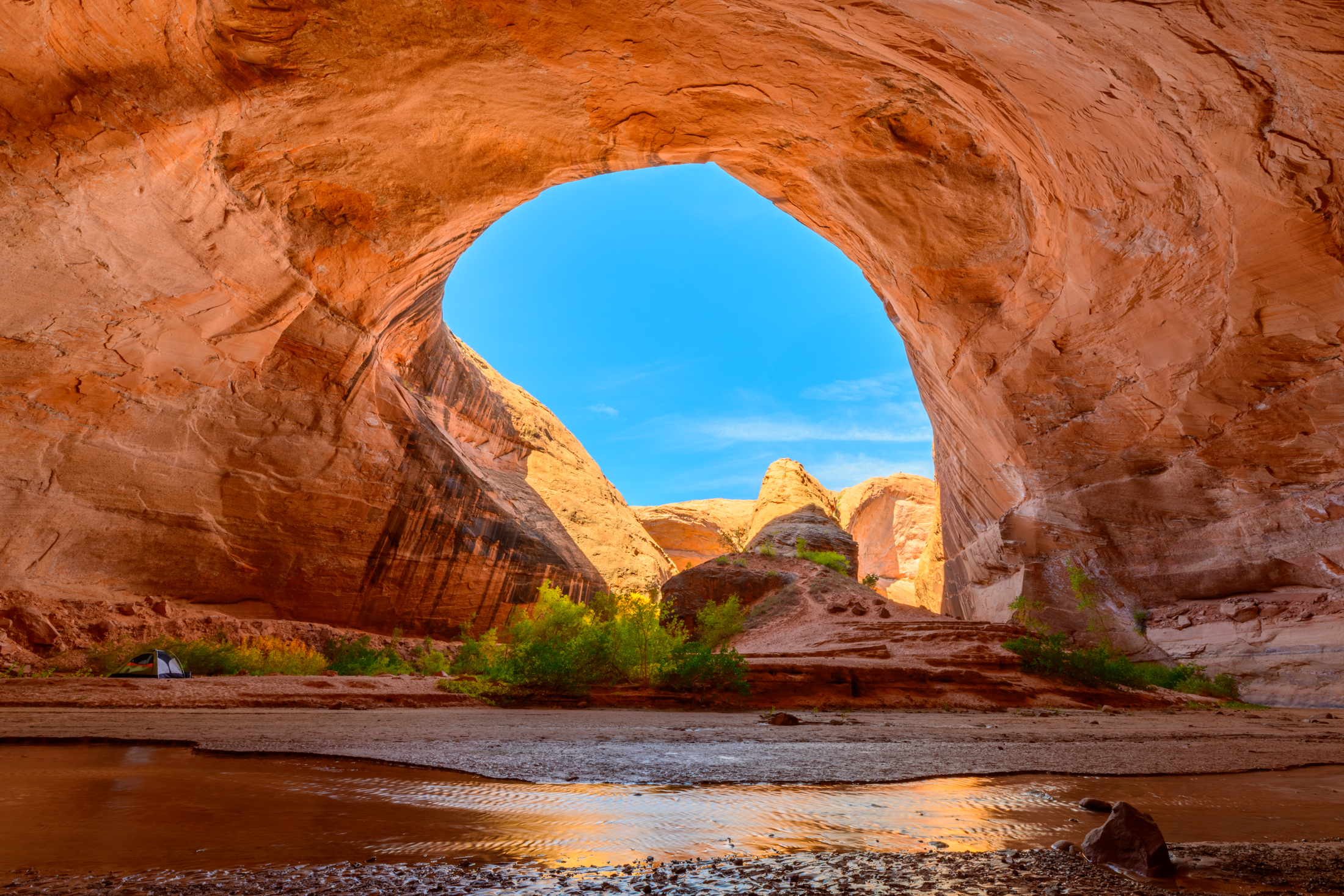
Coyote Gulch is the kind of canyon that converts people. One minute you are baking on a slickrock bench in southern Utah, the next you are walking beside cottonwoods with water curling around your boots, sandstone walls glowing apricot above you. It is classic Grand Staircase–Escalante: remote, deceptively rugged, and absolutely not a place to improvise your access plan at the last second.
This page focuses on the practical stuff first-timers actually need for Coyote Gulch and nearby slot canyons: which trailheads make sense, what “the road” really means out here, how permits typically work for day-use versus overnights, and a dry-versus-wet mindset that helps you make safer decisions without turning the trip into a fear fest.
Before you go: the mental model
Most “slot canyon safety” advice focuses on flash floods, which matters, but first-timers tend to miss a quieter truth: your risk changes depending on whether you are in a dry zone or a wet zone. Think of it like this.
Dry zones: where the decisions happen
Dry zones are the places you can usually stop, reassess, and turn around with minimal drama: trailheads, slickrock approaches, open washes, benches above the canyon, and wide canyon bottoms before they narrow. This is where you should be making the big calls: “Do we commit?” “Do we have a turnaround time?” “Does the sky and forecast match our plan?”
Wet zones: where options shrink
Wet zones are the places where small problems turn into big ones: narrow slots, pour-offs (short drops or ledges in the drainage that can become awkward downclimbs), wet narrows with algae-slick rock, deep sand after rain, and any section where the canyon walls rise and escape routes disappear. In wet zones, your best safety tool is usually prevention, because once you are in, you may not have a clean exit.
If you want one takeaway: make conservative decisions early, in dry zones, so you do not have to make desperate decisions later, in wet zones.
Permits and rules
Coyote Gulch sits within Grand Staircase–Escalante National Monument, and the lower canyon also crosses into Glen Canyon National Recreation Area. That means you are effectively traveling through shared jurisdiction, and rules can shift with season, impacts, and resource protection. The safest plan is to verify the latest requirements with the managing agency before you drive out.
Where to verify (and get the current process): start with the Escalante Interagency Visitor Center (BLM) for GSENM backcountry rules and current permit requirements, and check NPS Glen Canyon NRA guidance if your route travels into the lower canyon. I screenshot the relevant agency pages and note the phone number before leaving town, because cell service is unreliable once you are committed to Hole-in-the-Rock Road.
Day-use vs overnight
- Day-use: Day hiking often does not require the same permit as overnight travel, but day users are still subject to all corridor rules (including waste requirements, group size limits, and closures if in effect). Some areas use trailhead registration or other systems at times, so confirm what applies to your route and date.
- Overnight: Overnight trips in the Escalante backcountry commonly require a backcountry permit and may include group size limits, campfire restrictions, and human waste rules. Confirm where to obtain the permit (online vs in-person) and whether any quota, fee, or night limits apply.
Human waste: plan for it
This is the part people wish they had read before they packed the car: packing out solid human waste is currently required in Coyote Gulch under typical management guidance. Requirements can change, so treat this as a “confirm before you go” item with the Escalante Interagency Office and, if relevant, Glen Canyon NRA.
Bring WAG bags (or an equivalent approved human waste bag system) for everyone in your group, plus a couple extras. Plan to carry used bags out with you. Dispose of used, sealed bags in trash (follow the bag instructions), not in toilets or vaults unless an agency explicitly says otherwise. Odor-proofing helps: double-bag and use a dedicated outer bag.
What to confirm before you go
- Whether day-use requires any registration for your route and dates.
- Whether overnight permits are required, where to obtain them, and whether there is a fee.
- Any night limits for the Coyote Gulch drainage or popular camps.
- WAG bag requirements, including whether the rule applies to day use as well as overnight for your corridor.
- Fire restrictions and whether campfires are prohibited in the drainage or during your season.
- Parking rules at trailheads and whether any access roads are temporarily closed due to washouts or deep sand.
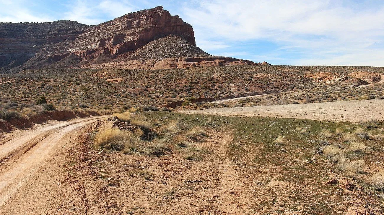
Road reality
Access is the make-or-break detail for Coyote Gulch. The main artery is Hole-in-the-Rock Road, a long dirt road off Highway 12 near Escalante. Conditions change fast with rain, grading schedules, and traffic. Expect washboards, dust, and occasional deep sand in side roads.
Road tips
- After rain, pause. Wet clay can turn roads impassably slick. A forecast that looks “fine” in town can still mean trouble on dirt.
- Do not trust the last review blindly. Conditions can change overnight. Use recent reports, but keep a backup plan.
- Fuel up in Escalante. Assume no services once you leave pavement.
- Carry a real spare and know how to use it. Sharp rock and washboard can be tire trouble magnets.
- Start early. Not just for hiking temps, but because driving dirt roads slowly and carefully takes longer than you think.
Coyote Gulch access
There are multiple ways into Coyote Gulch. The “best” one depends on what you want: an iconic entrance, the easiest navigation, the least sand, or the best odds that your vehicle can actually reach the trailhead.
Quick compare
| Route | Why choose it | Commitment | Exposure / sketch factor | Vehicle access risk |
|---|---|---|---|---|
| Hurricane Wash | Most straightforward navigation for many first-timers | Longer | Low | Moderate (main road) |
| Red Well | Another gradual wash approach, spreads use out | Longer | Low | Moderate to higher (varies) |
| Fortymile Ridge (Sneaker) | Efficient access to classic sights for day hikes | Shorter but steeper | Moderate to high (friction pitch) | Moderate to higher (side roads vary) |
| Crack-in-the-Wall | Iconic, dramatic entry | More committing | High (steep sand and slickrock) | Moderate to higher (side roads vary) |
Hurricane Wash
Why people choose it: This is often considered the most straightforward routefinding-wise. You hike down a wash and eventually meet Coyote Gulch. It is longer than some entries, but the terrain is generally less technical.
- Best for: Day hikers who want a simpler approach, and overnighters who prefer a gradual start.
- Watch for: Heat, sand walking, and the fact that “just a wash” can still become a problem if storms are building upstream.
Red Well
Why people choose it: Similar vibe to Hurricane Wash with a wash-based approach. Depending on current road conditions, it can be a good alternative that spreads use out a bit.
- Best for: Hikers who want a non-technical entry and are okay with mileage.
- Watch for: Road conditions to the trailhead and the same heat and sand factors.
Fortymile Ridge (Sneaker Route)
Why people choose it: This is one of the most popular ways to day hike straight to the classics like Jacob Hamblin Arch. It is shorter than the wash approaches and it feels efficient, especially if your goal is “maximum scenery in one day.”
What first-timers get wrong: The Sneaker Route is not “just a shortcut.” The entry and exit involve a steep friction pitch on slickrock that can be dangerously unforgiving, especially if you are tired, carrying too much, wearing the wrong shoes, or dealing with sand, moisture, or ice. The climb out at the end of the day is where a lot of people discover they have used up their margin.
- Best for: Confident hikers with good traction, solid balance, and enough experience to recognize when conditions make the pitch a no-go.
- Watch for: Exposure, tired legs on the exit, and any hint of wet or sandy slickrock that kills friction. If you look at it and your gut says “sketchy,” listen.
Crack-in-the-Wall
Why people choose it: It is dramatic and memorable. The entry involves negotiating a narrow crack and a steep slickrock and sand descent into the canyon system. For confident hikers, it is a highlight. For first-timers, it can feel like the moment you realize you have to reverse everything you just descended.
- Best for: Experienced desert hikers who are comfortable with routefinding and exposure and who understand how sand and slickrock behave when wet.
- Watch for: Steep sections, tricky footing, and the fact that rain can change traction and increase consequences.
The classics
Many first-timers come for the classic sights: Jacob Hamblin Arch, Coyote Natural Bridge, and the lush stretch of canyon where the creek and cottonwoods create that almost-unfair contrast with the desert above. No matter which entry you choose, build your day around a realistic turnaround so you are not rushing the best part.
Town Wander note: I am intentionally not giving mile-by-mile navigation here because route specifics and hazards shift, and because people tend to follow step-by-step instructions even when conditions say “not today.” Use current maps, official guidance, and recent condition reports for your exact plan.
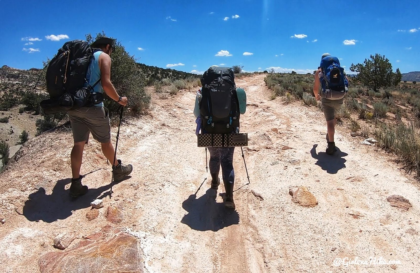
Day hike vs overnight
Day hike
If you are new to Escalante terrain, a day hike can be a smart first date with Coyote Gulch. You still get water, walls, arches, and that classic creek-walk feel, but you reduce logistics: less gear, fewer hours committed to the backcountry, and an easier retreat if weather shifts.
- Good for: First-time canyon visitors, shoulder-season travelers, and anyone unsure about sandy camps or water logistics.
- Key discipline: Set a firm turnaround time and stick to it. Desert darkness comes quickly in canyon bottoms.
Overnight
An overnight trip is where Coyote Gulch turns into a full sensory experience. Morning light on the walls. Coffee with your feet in the stream. Long pauses under cottonwoods. But overnights also add complexity: finding durable campsites, managing food storage and waste, and dealing with temperature swings.
- Good for: Confident hikers who have a solid backcountry system and can pack light while still being prepared.
- Key discipline: Keep campsites durable and impacts low. Coyote Gulch is popular because it is beautiful, and it stays beautiful only if we treat it like a shared home.

Slot canyon basics
Not every part of Coyote Gulch is a tight slot, but the Escalante region is slot canyon country. If you are pairing Coyote Gulch with nearby slots or you are simply new to narrow canyons, focus on a few practical basics that apply almost everywhere.
1) Read the sky like a local
In the desert, a “pretty” day can still produce intense, localized storms. If you see building towers of clouds, distant curtains of rain, or you hear thunder, treat that as real information, not background drama.
Also remember: storms do not have to be over you. Rain miles away in the drainage can raise flow downstream. This is why checking “chance of storms” for the broader region matters, not just whether it will rain on your exact pin.
2) Use the right forecast
Before slot terrain, I like an offline-capable weather source plus a second opinion. Look for language about thunderstorm potential, monsoon patterns in summer, and any mention of heavy downpours. If the forecast discussion is waving a yellow flag, believe it.
3) Know exits before you need them
In wet zones, ask yourself: “Where do we go if water rises?” If the answer is “I guess we run downstream,” you are already behind. Choose routes where escape options exist, and turn around early if they do not.
4) Expect slippery rock and cold water
Even in warm weather, shaded canyon water can chill you fast, and algae on sandstone can be slick. Trekking poles and grippy footwear help. So does moving slowly, especially when your pack shifts your balance.
5) Timing matters
- Late spring and fall often offer the best balance of temperatures and daylight.
- Mid-summer can be brutally hot on approaches and tends to bring a higher storm-risk profile.
- Winter can mean icy shade and very cold water. Beautiful, but not forgiving.
When a guide helps
I love independent travel, but the Escalante backcountry is not the place to treat self-reliance as a personality trait. A guide can be a force multiplier, especially for your first slot canyon experience.
Consider a guide if
- You are new to routefinding on slickrock and feel uneasy without a clear trail.
- You want to attempt a more committing entry or a technical side canyon and do not have the skills to evaluate it.
- You are traveling with a group where fitness and comfort levels vary and you want a professional to manage pacing and decision points.
- You are visiting during a season when weather volatility is higher and you want local judgment on go or no-go calls.
- You are short on time and want to maximize scenery while minimizing wrong turns and logistical hiccups.
What a good guide should do: talk through risk in plain language, name turnaround triggers, adjust plans based on conditions, and model low-impact practices. If someone is pressuring you to “send it” when the canyon says no, keep shopping.
What to pack
You do not need to haul your whole closet into Coyote Gulch, but you do need to be intentionally prepared. My sweet spot is light enough to move confidently, complete enough to handle the canyon if plans change.
Day hike essentials
- Navigation: offline map on your phone plus a backup (paper map or GPS).
- Weather: a forecast source you can access before you lose service, and a willingness to turn around if thunderstorm potential shows up in the wrong place.
- Water plan: a common strategy is to carry a few liters from the trailhead for the hot approach, then filter from the creek as needed once you are in the gulch. Filter or treat water, and when possible, pull from clearer flow and avoid obvious contamination areas.
- Footwear: grippy shoes that you do not mind getting wet, plus blister care.
- Sun: hat, sunscreen, and long sleeves you can actually hike in.
- Layers: a light insulating layer even if the forecast looks warm.
- Emergency basics: headlamp, first aid, and an emergency blanket.
- Waste kit: WAG bags for everyone, plus a sealable outer bag for packing them out.
Overnight add-ons
- Shelter and sleep system appropriate for big temperature swings.
- Food storage and a plan for keeping your camp clean.
- Waste system that matches current regulations for the area (still yes, WAG bags).
- Extra socks for wet feet and sand.
Escalante as base
Escalante is small, friendly, and perfectly positioned for early starts. It is also where you can make last-minute adjustments before committing to dirt roads.
- Check road and weather updates before you leave pavement.
- Stock up on water and snacks like you will not see a store all day, because you will not.
- Pick up WAG bags in town if you do not already have them.
- Build time for a coffee stop if that is your ritual. A calm start makes you a better decision-maker on the trail.
Go or no-go list
Use this quick set of questions at the trailhead. If you get uneasy answers, that is not a failure, it is information.
- Do we have a clear route plan and a turnaround time?
- Do we know where the wet zones are and what our exits are?
- Is the forecast stable enough for narrow terrain today, including thunderstorm potential upstream?
- Do we have enough water, food, and light if we are delayed?
- Do we have the required WAG bags and a plan to pack them out and trash them properly?
- Is our vehicle parked somewhere that will still be reachable if the road worsens?
Coyote Gulch will still be there if today is not your day. In my experience, the travelers who get the best stories are the ones who treat turning around as a skill, not a defeat.