Custer State Park: Wildlife Loop, Needles Highway, and Quick Stops
Maya Lin
Maya Lin is a travel journalist and outdoor enthusiast who believes the best trips combine rugged adventures with urban comforts. After spending six years backpacking across four continents, she founded Trail & Town Guide to help fellow travelers navigate both hidden mountain passes and bustling city neighborhoods with confidence.
Custer State Park is the Black Hills sweet spot where your “quick scenic drive” turns into an all-day greatest hits reel: bison herds that stop traffic, granite spires that glow at golden hour, and short trails that deliver big views without a full-on hike. If you want wildlife and a little windshield wow factor, the pairing of the Wildlife Loop and Needles Highway is hard to beat.
This guide is built for real trip planning: how long the drives actually take, which stops are worth pulling over for, how to handle bison-jams like a decent human, what passes you need, and how to tack on Wind Cave or Jewel Cave the same day without feeling rushed. If you’re pairing a cave tour in the morning, add that tour time separately.
Fast orientation: what’s where
Think of Custer State Park as a scenic triangle anchored by three drives:
- Wildlife Loop Road: the classic animal-spotting circuit through rolling prairie and pine pockets.
- Needles Highway (SD-87): narrow, twisty, and dramatic, with granite needles and tunnels. It runs between the Sylvan Lake area and the park’s northwestern side near US-385.
- Iron Mountain Road (US-16A): technically outside the park boundary in spots, but it connects beautifully toward Mount Rushmore with pigtail bridges and framed views.
Most visitors base in Custer or Hill City. From either, you can build a loop that minimizes backtracking and keeps the best scenery for the best light.
How long to budget
Distances in the Black Hills look short on a map. Wildlife, tunnels, and summer traffic make them feel longer. Use these as planning ranges:
- Wildlife Loop Road (about 18 miles): 1.5 to 3 hours depending on animal sightings and bison-jams.
- Needles Highway (about 14 miles): 45 to 90 minutes point-to-point, longer with photos and short walks.
- Leg-stretch stops + short hikes: add 1 to 3 hours depending on which you choose.
If you want a day that feels full but not frantic, plan on 5 to 7 hours inside the park. Add cave time separately.
Wildlife Loop tips
Best time of day
For both animals and calmer light, aim for early morning or late afternoon. Midday is still scenic, but wildlife can tuck into shade, and traffic is often heavier.
What you can realistically see
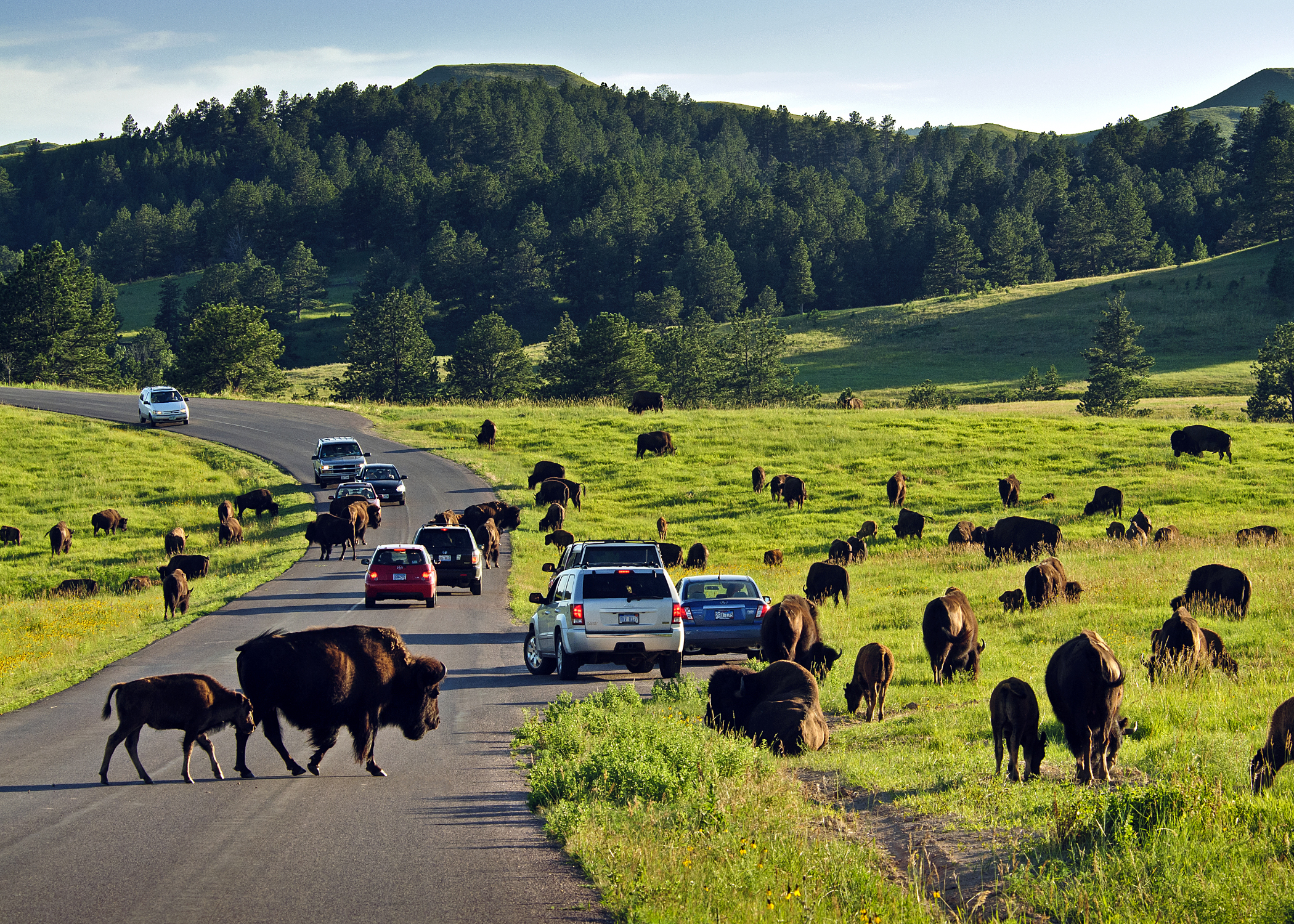
- Bison: the headliners and the most likely reason you will stop completely.
- Pronghorn: often out in open grasslands, especially in the morning.
- White-tailed and mule deer: common along edges of forest and meadow.
- Prairie dogs: you will usually hear them before you spot the whole town.
- Burros: friendly, curious, and known to wander up to cars. You often see them in the southeastern stretches of the Wildlife Loop. Keep your windows under control and your snacks out of reach.
Drive it like a safari
Go slow, scan the shoulders, and use pullouts when you stop. If you are the kind of person who misses animals because you are watching the road, let a passenger do the spotting.
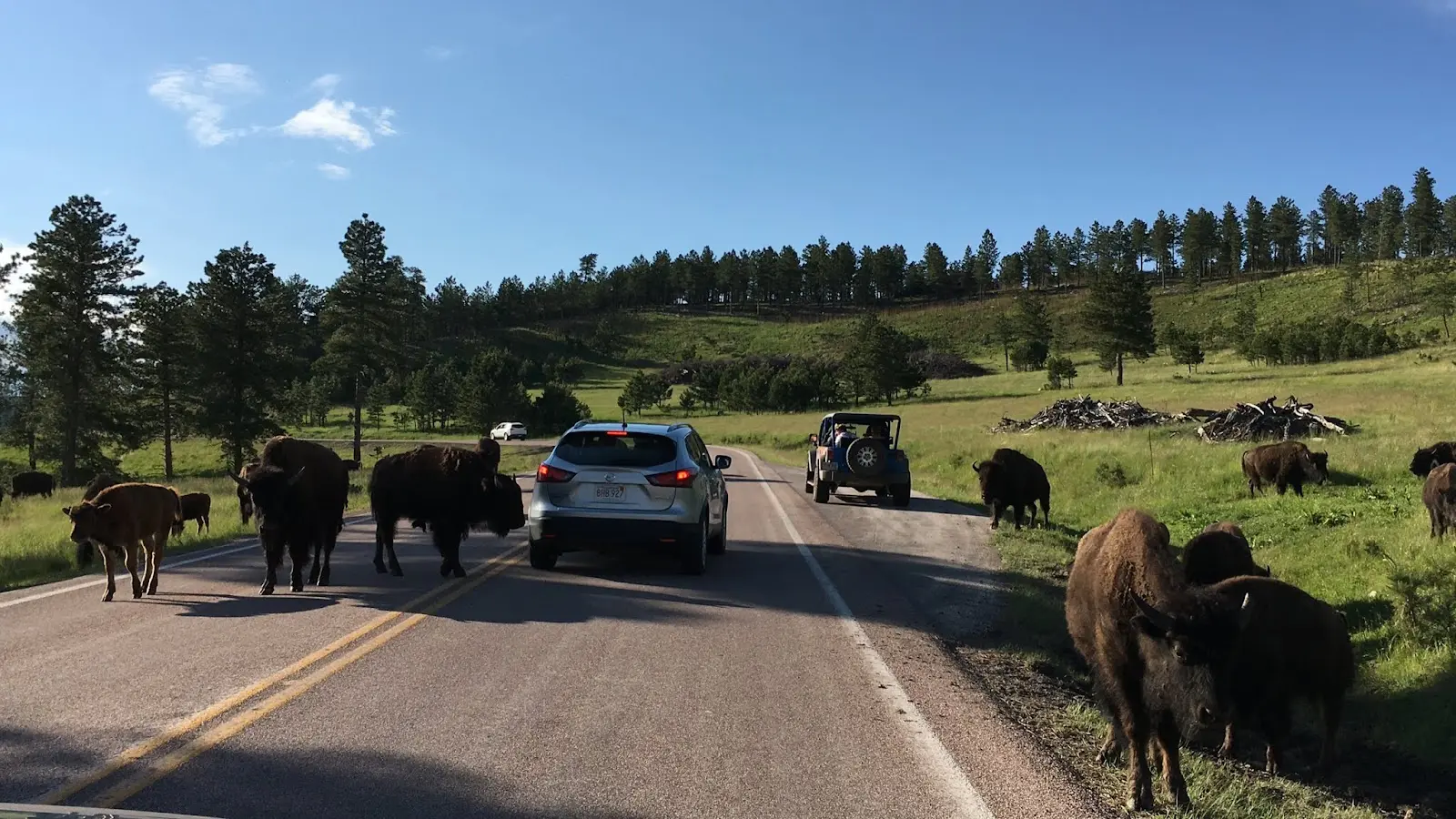
Bison-jam etiquette
Bison are not props. They are huge, fast, and fully capable of ruining a rental car day. If you only remember one thing: give them space and let them set the pace.
- Stay in your vehicle if bison are near the road. Do not step out for a “quick photo.”
- Do not honk and do not rev your engine to move animals along.
- Do not block both lanes if you can avoid it. If traffic is stopped, keep your car aligned and leave room so others can turn around if needed.
- Use pullouts for photos. If there is no pullout, keep it moving.
- Never feed wildlife, including the burros and prairie dogs. It changes their behavior and often ends badly for the animals.
If a bison is close enough to fill your phone screen without zoom, you are close enough.
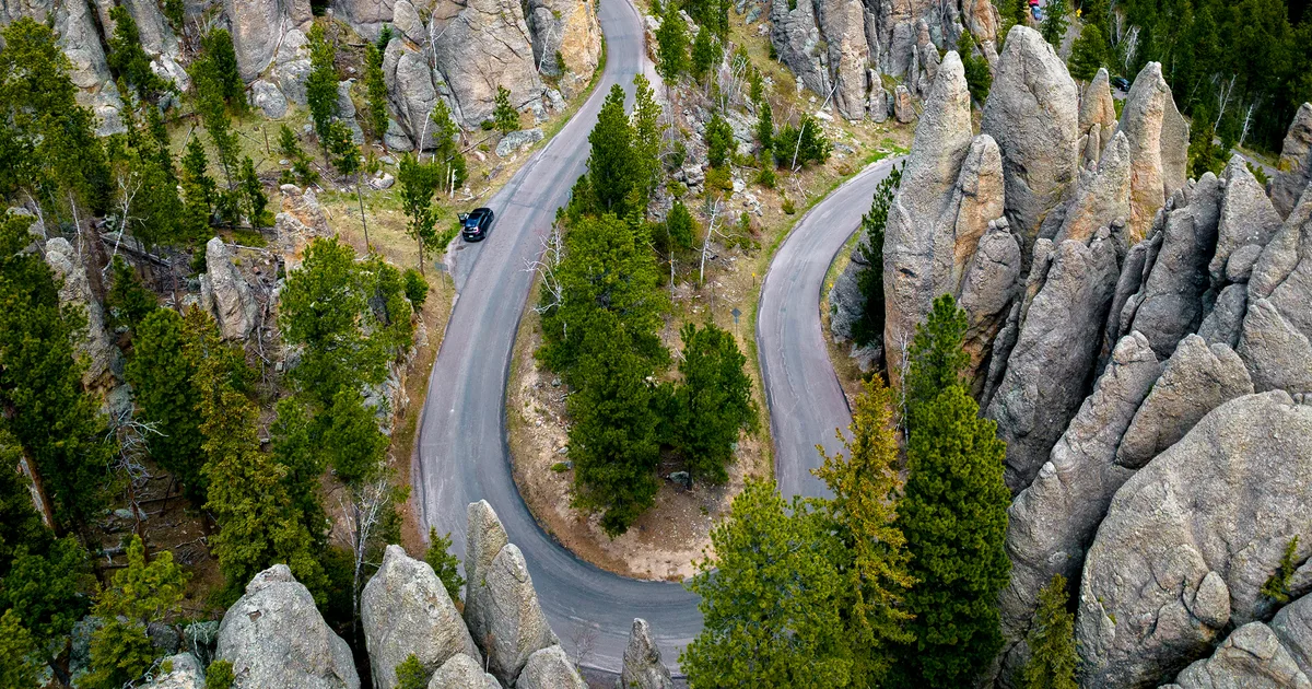
Needles Highway
Needles Highway is where Custer State Park turns from “wildlife drive” into “did we accidentally drive into a granite cathedral?” Expect tight curves, narrow lanes, and short tunnels carved through rock. It is slow driving by design, and that is the point.
Before you go
- Go slow and stay patient: this road rewards a relaxed pace and frequent pullouts.
- Oversize vehicles: large RVs and trailers can be challenging here due to narrow tunnels and sharp turns. A commonly cited pinch point is the Needles Eye Tunnel, often listed at about 8 ft 4 in wide and 11 ft 3 in high. Restrictions and advisories can change, so check South Dakota Parks current guidance before you commit, especially if you are towing.
- Weather matters: granite spires in fog are moody and beautiful, but slick conditions and low visibility slow everything.
Easy, high-reward stops
- Needles Eye area: classic photo stop with spire formations close to the road.
- Pullouts for spires: even the unnamed pullouts are worth it here. Some of the best views are the ones you did not pin.
Short trails, big views
The park is perfect for short hikes that feel like you did something, without needing a whole backcountry plan. A few reliable favorites:
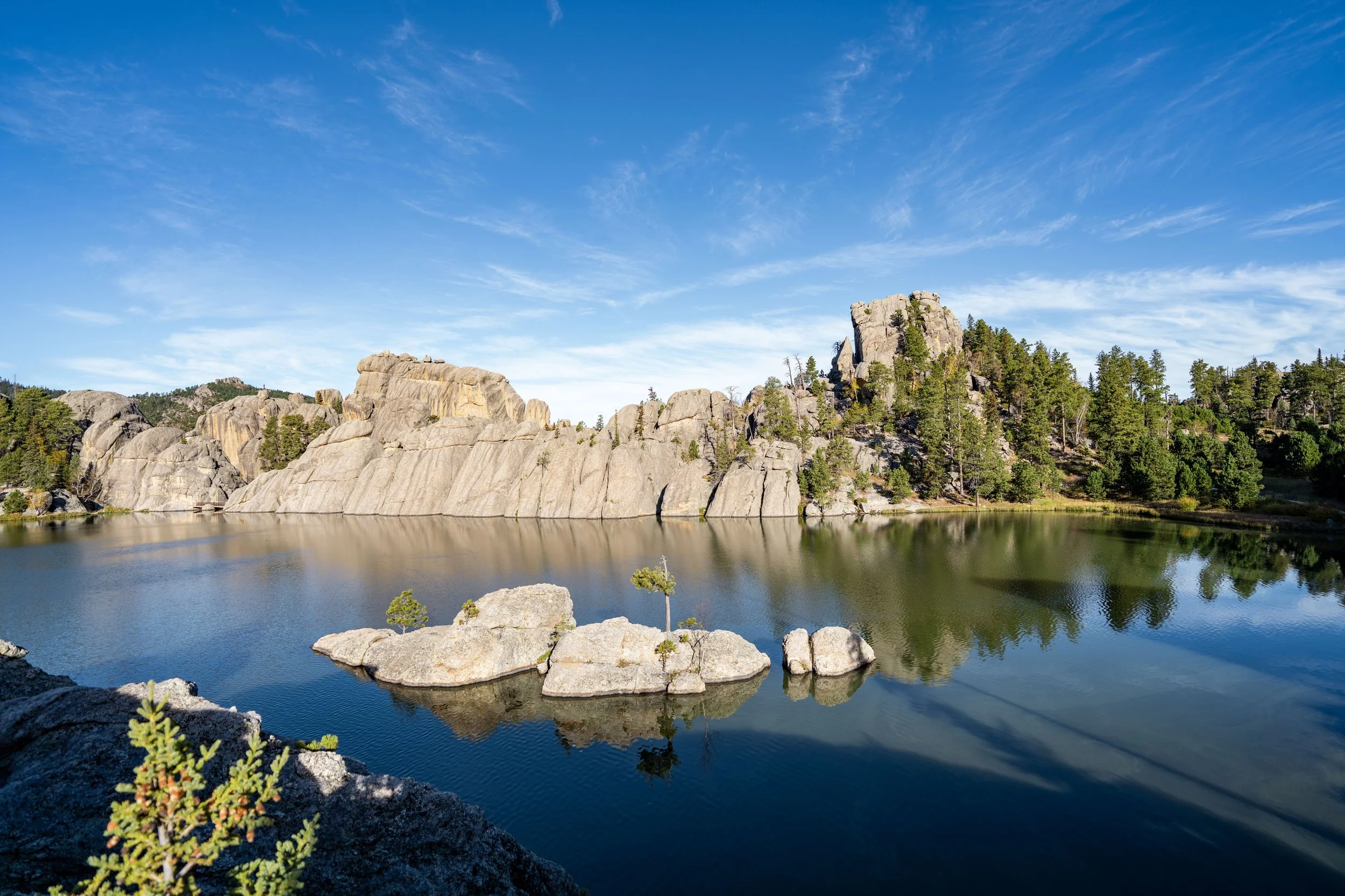
- Sylvan Lake Shore Trail: easy, scenic, and perfect for a reset between drives.
- Cathedral Spires Trail: short, steep-ish, and very Needles-core. Great payoff for the effort.
- Little Devil’s Tower: a bit more work, but the views are a serious upgrade if you want one “earned” overlook.
Conditions and closures can change seasonally, so check the trailhead signs and current park updates before you head out.
Quick leg-stretch stops
If you are doing a driving-heavy day, these short stops keep everyone happier without committing to a half-day hike.
Sylvan Lake stroll
Sylvan Lake is the park’s “how is this real?” postcard: smooth granite, calm water, and a compact loop feel that is perfect when you want movement without a sweat-fest. Even a 15 to 30 minute wander along the shore resets your brain after the windshield time.
Viewpoint pullouts
On both Wildlife Loop and Needles, pullouts are mini adventures. Step out, stretch, drink water, take your photos, and get back on the road before you turn a safe pullout into a traffic knot.
Prairie dog towns
Prairie dog towns are lively, loud, and weirdly charming. Great for families and anyone who needs a low-effort laugh break. Keep snacks packed away and stay on the safe side of any posted boundaries.
Fees and passes
Custer State Park requires an entrance license to drive the scenic roads and access day-use areas. Pricing and rules can change by season, so confirm current rates and purchase options on the South Dakota Game, Fish and Parks site before your trip.
- Where you will use it: Wildlife Loop, Needles Highway, day-use areas like Sylvan Lake, and other park roads.
- What to bring: a payment method, your license plate info if required, and a screenshot or printout if you buy online and your cell service is spotty.
If you are also visiting nearby federal sites (like national parks or monuments), note that a state park license is separate from federal passes.
Caves + park combo
This is my favorite way to structure a Black Hills day: cool, cave air in the morning, then sunshine and big views in Custer State Park after lunch.
Where the caves are
- Wind Cave sits just south of Custer State Park (it basically borders the Black Hills area you are already driving through).
- Jewel Cave is farther west, near the town of Custer but outside the state park, so it usually adds a little more drive time.
Option A: Wind Cave morning
- Morning: Wind Cave (tour timing varies seasonally, so book or check schedules ahead).
- Midday: drive toward Custer State Park, grab lunch in Custer or pack a picnic.
- Afternoon: Wildlife Loop for animals, then Needles Highway for late light on the spires.
Option B: Jewel Cave morning
- Morning: Jewel Cave tour.
- Early afternoon: enter Custer State Park and do the Wildlife Loop.
- Late afternoon to sunset: Needles Highway and Sylvan Lake area for the prettiest glow.
Why caves first? Tour start times can be more rigid than park driving, and afternoons are prime for stopping when wildlife appears without stressing about a reservation clock.
One-day plan
Direction tip: If you want the smoothest flow and prettier light on the spires, do Wildlife Loop first and save Needles Highway and Sylvan Lake for later in the day. If you are starting near Sylvan Lake early, flip it.
- Morning: Wind Cave or Jewel Cave tour.
- Lunch: Custer town for an easy refuel and coffee stop.
- Early afternoon: Wildlife Loop Road, taking pullouts as you find them.
- Mid-afternoon: prairie dog stop and a short leg-stretch.
- Late afternoon: Needles Highway.
- Sunset bonus: Sylvan Lake shoreline stroll if you still have energy.
If you only have half a day, prioritize Wildlife Loop + one short stop or Needles + Sylvan Lake, depending on whether you want animals or rock scenery more.
Food, fuel, restrooms
- Fuel and groceries: your easiest, stress-free bet is stocking up in Custer or Hill City before you head deep into the park.
- Restrooms: you will find restrooms at major day-use hubs (like Sylvan Lake) and some popular stops, but do not assume they are at every pullout.
- Cell service: inconsistent. Have your map available offline and do not count on last-minute googling.
Season notes
- Summer: best access, biggest crowds, and the most bison-jam potential. Build in buffer time.
- Shoulder seasons: fewer people and great light, but shorter days and more variable weather.
- Winter: some roads and services can be limited or temporarily closed due to snow and ice. Check current conditions before you go.
What to pack
- Binoculars: makes wildlife viewing safer and way more satisfying.
- Water and snacks: bison-jams are not the moment to realize you are hungry.
- Layers: caves are cool, and Black Hills weather can flip fast.
- Offline maps: service can be inconsistent on park roads.
- Trash bag: pack it out, including coffee cups and snack wrappers.
Responsible travel
- Stay on trails around lakes and pullouts to protect fragile plants and soils.
- Keep distance from all wildlife, not just bison.
- Leave gates and fences alone and respect closures.
- Support local by grabbing a meal in Custer or Hill City and buying supplies before you enter the park.
Custer State Park is iconic because it still feels wild. The best way to keep it that way is to drive gently, stop thoughtfully, and treat every animal encounter like you are visiting someone else’s home, because you are.