Easy Day Hikes Near Escalante and Boulder
Maya Lin
Maya Lin is a travel journalist and outdoor enthusiast who believes the best trips combine rugged adventures with urban comforts. After spending six years backpacking across four continents, she founded Trail & Town Guide to help fellow travelers navigate both hidden mountain passes and bustling city neighborhoods with confidence.
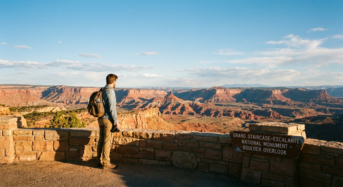
Grand Staircase–Escalante National Monument can feel like a choose-your-own-adventure book with 1,000 dusty pages. If it is your first time basing in Escalante or Boulder, you do not need a high-clearance truck or a canyon-navigation résumé to get a big payoff. The key is picking hikes with straightforward trailheads, modest mileage, and scenery that looks far more “expedition” than it actually is.
This guide focuses on easy day hikes on the monument’s Escalante side, especially routes you can do as short loops or relaxed out-and-backs. I will also flag seasonal access, sun exposure, and a simple way to pair these hikes with Hole-in-the-Rock Road without turning your day into a pullout-hopping marathon.
Before you go: the desert basics that matter here
Hydration and heat
Most “easy” in Grand Staircase–Escalante is easy on the ankles, not easy on the body. Low humidity, reflective sandstone, and long stretches without shade can surprise first-timers.
- Bring more water than you think. For mild-weather day hikes, a practical baseline is 2 to 3 liters per person. In late spring through early fall, many hikers are happier with 3 to 4 liters, especially on exposed slickrock routes.
- Start early. Morning light is also when the colors look best, and you will beat both heat and crowds on the most popular trails.
- Electrolytes help. If you are sweating, you are losing salt even if it evaporates fast.
Sun exposure and footing
- Wide-brim hat and sunscreen are not optional. Many routes are fully exposed for long stretches.
- Traction matters. Slickrock is usually grippy when dry, but sand on rock can be slick. After rain, clay-based dirt roads can become impassable and trails can get muddy fast.
Road reality check
Trail difficulty and road difficulty are two separate things. Check current conditions with the Escalante Interagency Visitor Center before committing, especially after storms.
- UT-12 corridor hikes are generally the safest bet year-round for standard vehicles.
- Some trailheads off unpaved roads can be fine when dry and a disaster when wet. If you see deep ruts, standing water, or sticky mud, turn around early.
Leave No Trace note: Grand Staircase–Escalante is rugged and fragile. Stay on durable surfaces, do not build cairns, and avoid stepping on cryptobiotic soil, the dark, crusty living layer that helps prevent erosion.
Easy hikes near Boulder (UT-12 corridor)
If you want an easy day with high scenery-to-effort ratio, the UT-12 corridor near Boulder is your friend. You can have a morning hike, a great lunch, and still be back in time for golden-hour views from the highway overlooks.
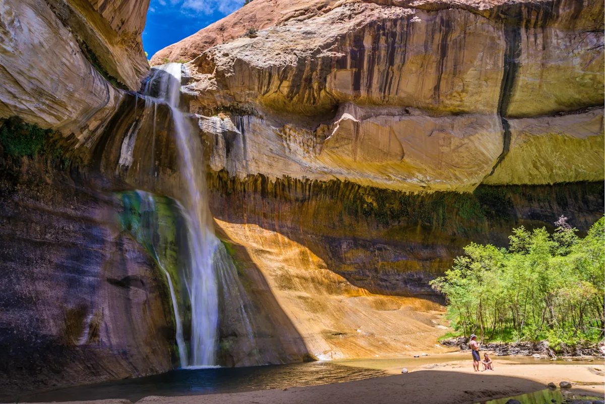
Lower Calf Creek Falls
Why it is worth it: A reliable desert creek, a deep pool, and a 126-foot waterfall framed by red walls. It is popular for a reason.
- Type: Out-and-back
- Distance: About 6 miles round trip
- Time: 3 to 4 hours at an easy pace
- Trailhead: Calf Creek Recreation Area off UT-12 (paved access)
- Good for first-timers because: Clear trail, steady grade, predictable navigation
What to know: This is one of the more sun-exposed “easy” hikes because the canyon is wide. Start early. The creek makes it feel cooler than it is, so do not let that trick you into under-drinking. Swimming can be tempting, but water is cold and conditions vary. Fees: This trailhead is in a developed recreation area and typically requires a paid day-use fee.
Easy hikes near Escalante (quick wins close to town)
Escalante is small, but it is an excellent base if you want to stack short hikes between coffee, groceries, and a decent dinner. These options keep you close to services and do not require committing to long drives down remote roads.
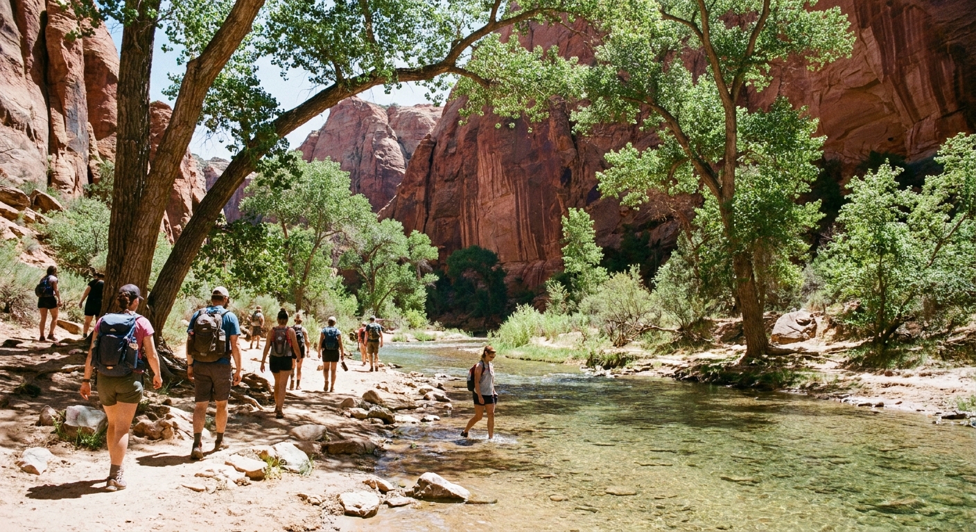
Escalante River Trail (Town to the river)
Why it is worth it: A mellow introduction to the Escalante River corridor. You get cottonwoods, river sounds, and that immediate shift from dusty town to cool green shade.
- Type: Out-and-back (choose your turnaround)
- Distance: Flexible, often 2 to 4 miles round trip depending on where you turn around
- Time: 1 to 2.5 hours
- Access: Close to town; ask locally for the current best access points and parking etiquette
What to know: Expect sand and occasional shallow water depending on season. Mosquitoes can show up near the river in warmer months, especially around dusk. Many GSENM trailheads use free day-use permit sign-in boxes. If you see one, fill it out.
Wide Hollow Reservoir walk (sunset stroll)
Why it is worth it: When you want something truly low effort, the reservoir area can be a calming evening leg-stretcher with open views.
- Type: Short walk, informal loops possible
- Distance: Choose your own
- Time: 30 to 90 minutes
What to know: Wide Hollow Reservoir is inside Escalante Petrified Forest State Park, so expect a day-use entry fee. Bring wind layers. The open basin can feel breezy even when town is calm.
Easy loops that still feel big
Loops are my favorite for first-timers because they keep the day feeling like a journey, even if the mileage is modest. These are classic “big scenery, small commitment” routes, but they do require paying attention to weather and road conditions.
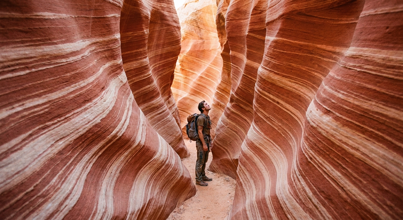
Zebra Canyon (approach is easy, slot can be serious)
Why it is worth it: Zebra Canyon is one of the most striking short slots in the area, and the approach hike is fairly straightforward. When it is in friendly condition, it can be a perfect half-day adventure.
- Type: Out-and-back
- Distance: Commonly 5 to 7 miles round trip depending on how far you go
- Time: 3 to 5 hours
- Access: Trailhead reached via unpaved roads that can be difficult after rain
First-timer notes: Here is the nuance: the hike to the canyon is usually moderate and easy to follow, but the slot itself is not consistently beginner-friendly. Zebra frequently holds waist to chest-deep, very cold water, and depending on sand buildup you may need tight moves (stemming or chimneying) in narrow sections. Flash flood risk is real in slots. If storms are in the forecast anywhere in the region, pick a different hike.
About the Zebra to Tunnel “loop” idea: Linking Zebra and Tunnel into a loop typically means cross-country travel and route-finding. That can be fun for experienced desert hikers with solid navigation skills, but it does not match the “no navigation résumé” promise. For most first-timers, treat Zebra as a straightforward out-and-back and skip the loop.
Easy viewpoints near Boulder Mountain
One reason I love basing in Boulder is that you can toggle between red rock and higher-elevation air quickly. When Escalante feels like an oven, Boulder Mountain can be a reset button. Just remember weather changes fast up high.
Short forest walks and lake pull-ins
Why it is worth it: In summer, the forest shade can feel like a different state. In fall, aspens can steal the show. These are not marquee “named trail” experiences so much as choose-your-own short hikes.
- Type: Short walks, informal loops
- Best season: Late spring through fall, depending on snowpack
- What to know: Afternoon storms are common in monsoon season. Keep an eye on sky darkening and thunder.
Hole-in-the-Rock Road: pair it without overdoing it
If you have already read about Hole-in-the-Rock Road as a series of “stop here, look there” pullouts, here is the upgrade: use the road as a single themed day, anchored by one hike that justifies the drive, plus one short add-on if you have energy.
A simple pairing strategy
- Pick one primary hike that requires the drive down Hole-in-the-Rock Road (for many first-timers, this is the Zebra area if conditions are right, or another single destination you feel confident about).
- Add one short, low-stakes bonus stop only if the road is in good shape and you are ahead of schedule.
- Skip the temptation to do everything. The road itself is tiring, and you will enjoy the day more if you have time to linger in your main canyon.
Best bonus stop for almost everyone: Devils Garden. It is the definitive easy, family-friendly spot on Hole-in-the-Rock Road, with short wandering paths among hoodoos and sandstone shapes. Low commitment, high payoff.
Two sample day plans
Plan A: First-timer sampler
- Early start from Escalante
- Primary hike: Zebra Canyon out-and-back (only if weather is stable and water levels look reasonable for your group)
- Bonus stop: Devils Garden on the way back
- Back in town for a late lunch and a slow coffee
Plan B: Waterfall morning, red rock afternoon
- Morning: Lower Calf Creek Falls (start early to beat heat)
- Afternoon: scenic drive toward Escalante with one short walk near town
- Evening: dinner in Boulder or Escalante, depending on where you are staying
Why this works: You get one “big” memory and one “small” memory, and you still have energy left for tomorrow.
Seasonal timing
Spring (March to May)
- Great temperatures, but expect wind.
- After storms, dirt roads can be sticky and impassable.
- Waterfall and creek hikes are especially rewarding.
Summer (June to early September)
- Plan early starts and shorter, shaded routes when possible.
- Monsoon storms can trigger flash flood risk in slot canyons.
- Bring extra water and sun protection even on “quick” hikes.
Fall (mid-September to November)
- Arguably the sweet spot: warm days, cool nights, fewer storms.
- Lighting is gorgeous for photography in canyons and along UT-12.
Winter (December to February)
- UT-12 stays accessible often, but snow and ice can impact Boulder Mountain and shaded trail sections.
- Shorter days mean tighter turnarounds.
What to pack for these easy hikes
- Water: 2 to 4 liters per person depending on temperature and exposure
- Sun: Hat, sunglasses, sunscreen, lip balm
- Footwear: Trail shoes with good grip; expect sand
- Layers: A light insulating layer for shoulder seasons, plus a wind shell
- Navigation: Offline map downloaded before you lose service
- Safety: Headlamp, small first aid kit, and a snack buffer beyond what you think you need
Quick FAQs
Do I need a permit or fee?
Often, yes. Many GSENM trailheads use free day-use permits via on-site sign-in boxes. Fill one out when you see it, including for popular areas like Zebra and many Escalante River accesses. Separately, some developed sites charge fees, and Lower Calf Creek Falls is typically a paid day-use area. Rules can change, so confirm current requirements with the Escalante Interagency Visitor Center.
Are these hikes good for kids?
Lower Calf Creek Falls and short river walks can work well for families used to walking, but heat and sun exposure are the limiting factors. For slot canyons, evaluate comfort with tight spaces, cold water, and scrambling, and avoid them when storms are possible.
Can I do these with a regular car?
UT-12 corridor hikes like Lower Calf Creek Falls are standard-car friendly. Routes reached via unpaved roads can vary dramatically with weather. If rain has fallen recently, assume conditions may be worse than they look at the start.
One last local-style tip
If you only have one full day, pick either a UT-12 corridor day (waterfall, overlooks, and an easy river stroll) or a Hole-in-the-Rock Road day (one anchor hike plus one bonus stop like Devils Garden). Trying to combine both often turns your day into windshield time. Grand Staircase–Escalante rewards lingering, especially when the best moment is not a viewpoint, but the quiet stretch of trail where you finally hear nothing but wind and sandstone.