Fort Bowie: Apache Pass Walk + Chiricahua Half-Day
Maya Lin
Maya Lin is a travel journalist and outdoor enthusiast who believes the best trips combine rugged adventures with urban comforts. After spending six years backpacking across four continents, she founded Trail & Town Guide to help fellow travelers navigate both hidden mountain passes and bustling city neighborhoods with confidence.
Fort Bowie National Historic Site is one of those places that sneaks up on you. The drive feels like you are leaving “Arizona road trip” behind and entering something quieter and more human-scale, where a single pass, a stubborn little spring, and a collision of worlds shaped travel across the Southwest.
The best part is that you earn it on foot. Fort Bowie is not a “pull up, snap a photo, leave” site. You walk the same corridor people relied on, fought over, and crossed for generations, then you can pivot to the pure geology of Chiricahua National Monument for hoodoos and high-country air.
Quick facts before you go
- Main hike: Fort Bowie Interpretive Trail (out and back)
- Distance: about 3 miles round trip (check current NPS info or trail signage for the latest)
- Time: 1.5 to 3 hours depending on stops
- Difficulty: easy to moderate, mostly gentle grades with a few rolling sections
- Facilities: limited. The visitor center is at the end of the trail, not at the parking area
- Food and fuel: none at the site. The nearest reliable services are typically in Willcox, with limited options in Bowie
- Cell service: often spotty or nonexistent
Because the site is remote and the experience is trail-based, Fort Bowie rewards anyone who plans like they are heading out for a short desert hike, not like they are making a quick historic detour.
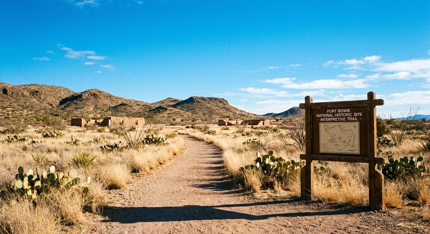
Along the interpretive trail
The Fort Bowie experience is essentially a story you read with your feet. The trail is well established and signed, and it threads together multiple layers: the natural choke point of Apache Pass, the essential water source at Apache Spring, and the remains of military life that rose around it. It is an out-and-back route, so you return the same way you came in.
Trailhead to the pass
From the parking area, the path heads into open desert with wide views and that classic southeastern Arizona palette: muted grasses, ocotillo and scrub, and rocky slopes that look deceptively close. Give yourself a few minutes to acclimate to the sun and exposure. Shade is limited and the air can feel startlingly dry even on mild days.
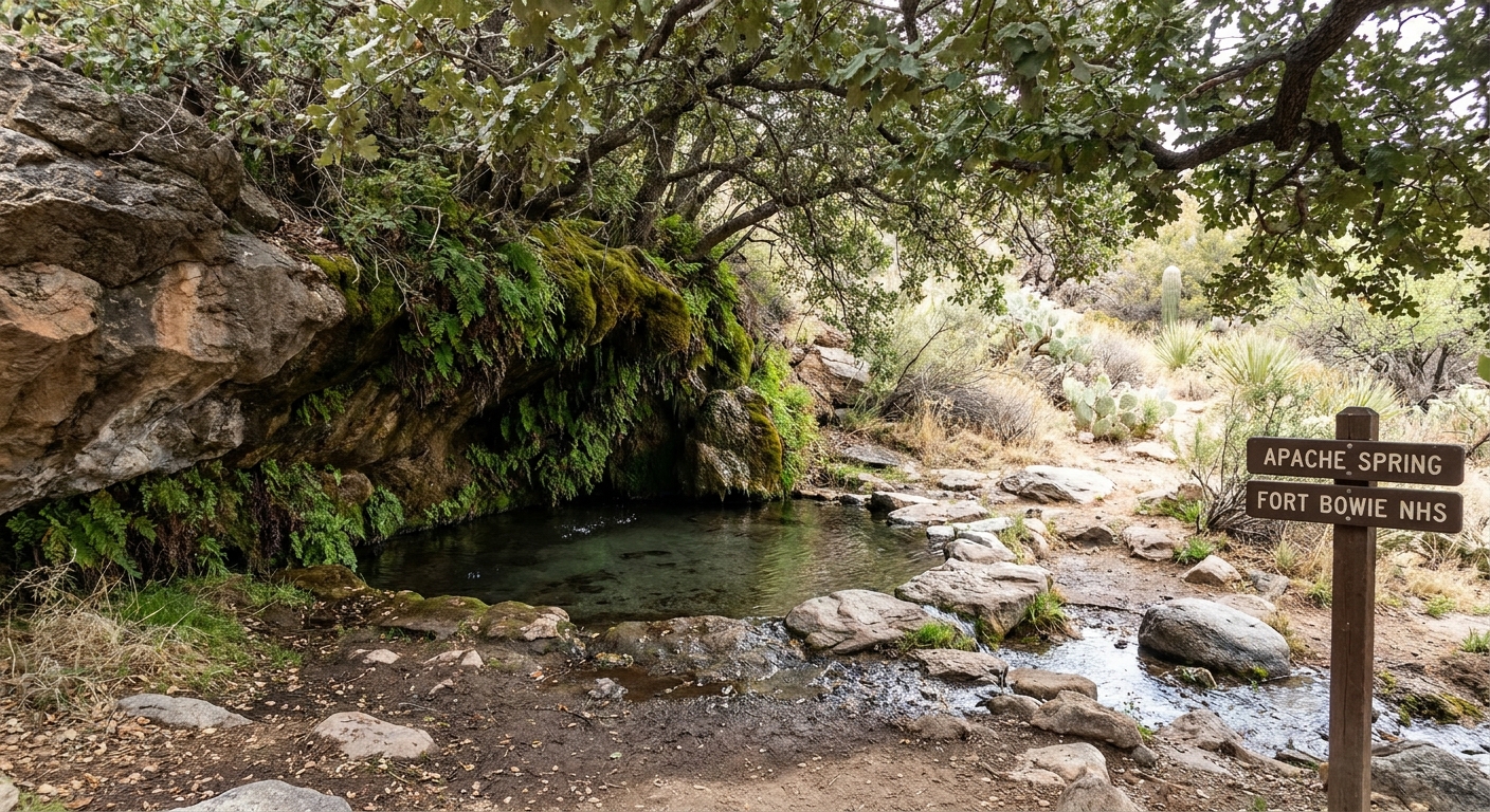
Apache Spring
Apache Spring is not just a scenic stop. It is the hinge of the whole site. In desert country, dependable water is power, and this spring helped make Apache Pass a strategic route long before any fort existed.
One important note for planning and safety: do not rely on the spring for drinking water. Treat it as a historic and ecological lifeline, not a refill station.
The payoff at the end
Here is the detail that surprises first-timers: the main destination is not at the parking lot. The visitor center and the primary fort ruins are at the end of the 1.5-mile hike. That is part of why Fort Bowie feels so different from many historic sites. You arrive like the people who had to arrive here, by crossing the pass.
At the end, take time to do three simple things:
- Visit the hike-in visitor center. This is where the broader context clicks, especially if you read the exhibits after walking the pass. Check current NPS hours and any seasonal changes or temporary closures before you commit to the drive.
- Walk the ruins slowly. Foundations and low walls can look subtle at first, but the layout becomes clearer when you stop trying to “see it all” at once.
- Save a little water and patience for the return. The hike back is the same distance, and in midday heat it can feel longer than you expect.
Context in two minutes
Apache Pass is a natural corridor through the Chiricahua Mountains, and Apache Spring made it one of the few dependable water sources in the area. That combination shaped movement and conflict in the region, including the U.S. Army’s fort presence and the long struggle over homelands and control of travel routes. The site is at its best when you let it hold complexity without rushing to simplify it.
Spring and ruins etiquette
Fort Bowie is both fragile and meaningful, and it sits in a living landscape. A few simple habits keep it that way.
- Stay on the trail and respect barriers. Shortcutting damages vegetation and accelerates erosion, especially around the spring and ruins.
- Do not touch, move, or pocket artifacts. Even “small” pieces matter. Leave everything exactly where you found it.
- Give the spring space. Treat Apache Spring like a vital resource, not a photo prop. Avoid stepping into wet areas or trampling plants around the water.
- Quiet helps. Many visitors come for reflection as much as history. Keep voices and music low.
- Pack out all trash. Including food scraps. They attract wildlife and degrade an already sensitive corridor.
If you like to journal or sketch, this is a perfect place for it. Slow down, read the signs, and let the layers of the pass make sense.
Heat, storms, and rattlesnakes
Southeastern Arizona is not where you want to be casual about conditions. Fort Bowie is exposed, remote, and easy to underestimate. There is little shade on route and no treated water available on the trail, so plan to be self-sufficient.
Seasonal heat
- Late spring through early fall: plan an early start. The trail has long sun stretches, and heat can spike fast.
- Carry more water than you think you need. For most people, at least 1 liter per person for this short hike is the floor, not the ceiling, especially in warm months.
- Sun protection is mandatory. Hat with brim, sunglasses, and sunscreen. Light long sleeves can feel cooler than bare skin.
Monsoon and lightning (summer)
Storms can build quickly during monsoon season, often July through September. If you hear thunder, drop the “push to the end” mentality and turn back. Desert washes and low spots can flood, and lightning risk is real in open terrain.
Rattlesnakes
Rattlesnakes are part of the ecosystem here. Most want nothing to do with you, but they love the same things you do: edges of trails, warm rocks, and shaded spots near vegetation.
- Watch your step around rocks, brush, and any narrow sections.
- Do not put hands where you cannot see. This includes scrambling near walls or reaching onto ledges for photos.
- Give snakes distance. If you encounter one, pause, step back, and let it move off.
Remote access
Fort Bowie’s remoteness is part of its magic, but it does require an honest plan. This is not a “gas station every 10 minutes” region.
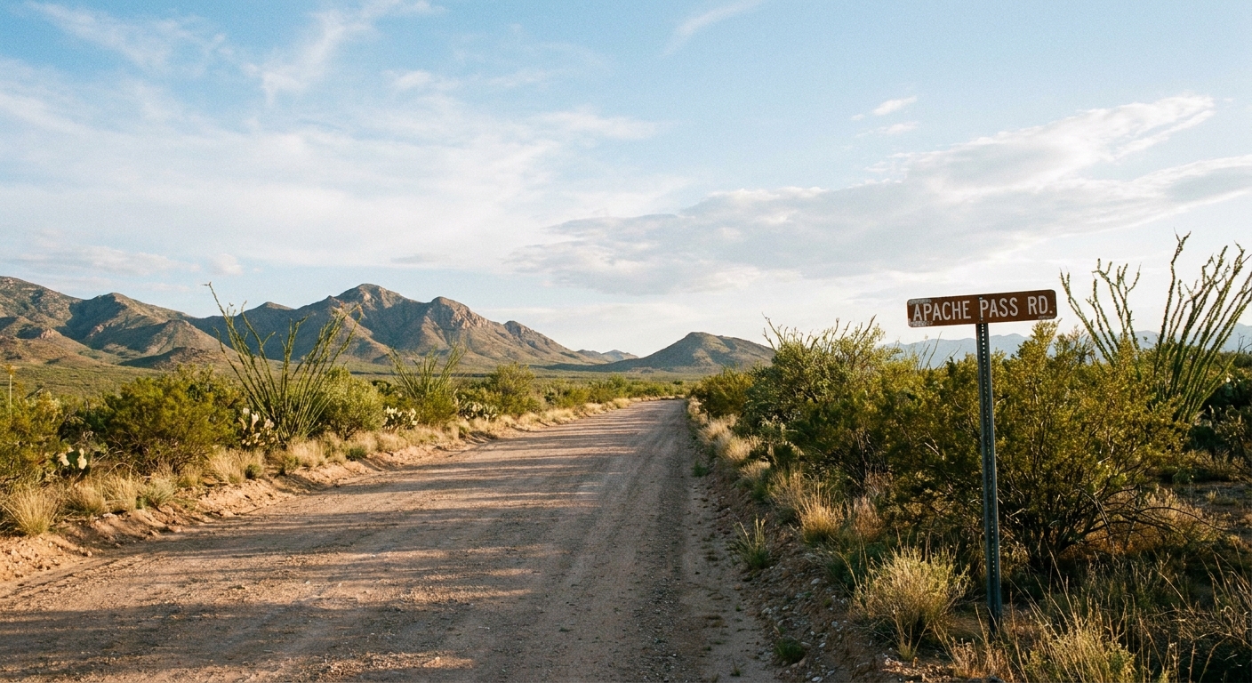
Where you start
Most visitors begin at the trailhead parking area in the Apache Pass area. Road conditions can change with weather, so check current conditions if storms have moved through recently. Drive with a little patience and give yourself buffer time.
From Willcox
Willcox is the most comfortable base for many travelers: more food options, reliable fuel, and an easier resupply if you are pairing Fort Bowie with Chiricahua. Expect a drive that feels rural and quiet, with the last stretch leading you into the Apache Pass area.
From Bowie
Bowie is closer on the map and can be convenient if you are already moving along I-10. Services are limited, so treat it as a waypoint rather than a full hub.
Road notes
- Expect slower speeds. Give yourself buffer time.
- Do not count on cell service. Download offline maps before you leave Willcox or a stronger-signal town.
- Fuel up early. Make “half tank” your minimum before heading into the area.
- Weather changes road conditions. After storms, dirt sections can be messy or rutted.
Half-day plan: Fort Bowie + Chiricahua
This is my favorite way to do it if you want both history and hoodoos in one satisfying chunk of day, without feeling like you sprinted through either.
Option A: Fort Bowie then Chiricahua
- Early morning: Drive in and hike the Fort Bowie Interpretive Trail while it is cooler and quieter. Save time and energy for the visitor center and ruins at the end.
- Late morning: Snack and reset at your car. This is a great moment for a simple picnic: nuts, fruit, something salty, and plenty of water.
- Midday to afternoon: Head toward Chiricahua for a hoodoo hike that matches your energy level.
Why this works: Fort Bowie is exposed and gets hot quickly. Chiricahua, depending on where you hike, can offer slightly cooler temps and more shade at elevation.
Option B: Chiricahua then Fort Bowie
If you are chasing sunrise photos among the rock formations, flip the order. Just remember that late afternoon at Fort Bowie can still be very warm in summer, and you do not want to be driving remote roads tired and low on water. Also keep an eye on closing times if you want to spend meaningful time at the hike-in visitor center.
Pick one Chiricahua hike
Since you already have a full Chiricahua page, think of this pairing as picking a single anchor hike that complements Fort Bowie’s story-heavy half of the day:
- Want maximum hoodoo drama: pick one of the monument’s classic rock-garden routes.
- Want a lighter afternoon: choose a shorter viewpoint-oriented hike and spend time pulling over at scenic stops instead.
- Want to stretch your legs: go longer at Chiricahua, but only if you kept Fort Bowie genuinely half-day and you are carrying enough water.
The goal is variety: Fort Bowie for narrative and place, Chiricahua for geologic wonder. You do not need to “complete everything” in one day to feel like you got the best of both worlds.
What to pack
- Water: more than you think you need
- Electrolytes: packets or tablets help in heat
- Sun kit: hat, sunscreen, sunglasses
- Closed-toe shoes: for rocks, spines, and surprise critters
- Snacks: especially if you are pairing with Chiricahua
- Offline maps: screenshot directions and trail info
- Basic first aid: blister care and a wrap are worth their weight
If you are traveling sustainably, this is an easy win day: refillable bottle, packed lunch, and leaving the site exactly as you found it.
Small details
A few things I wish everyone knew before they go:
- Give yourself permission to read. The interpretive signs are the experience. Build time for them.
- Plan one quiet minute at the spring. Not for a photo, just to absorb the idea of water as a lifeline.
- Start earlier than you think. It is the easiest way to make the day feel spacious instead of stressful.
- Check the basics before you leave signal. Confirm current NPS hours, any advisories, and the latest trail details.
Fort Bowie is not flashy. It is honest. If you let it be slow, it becomes unforgettable.
Trip planning snapshot
If you want the simplest version of this day:
- Base town: Willcox for fuel, food, and easier logistics
- Do first: Fort Bowie Interpretive Trail (about 3 miles round trip) including the hike-in visitor center and ruins at the end
- Do second: one focused hoodoo hike at Chiricahua plus scenic stops
- Non-negotiables: water, sun protection, time buffer for remote roads, and a quick check of current NPS hours and conditions
When you are ready to swap battlefield history for stone spires and forested overlooks, point your tires toward Chiricahua and let the day end on pure awe.