Kodachrome Basin: Angel’s Palace Trail and Quick Add-Ons

Maya Lin
Maya Lin is a travel journalist and outdoor enthusiast who believes the best trips combine rugged adventures with urban comforts. After spending six years backpacking across four continents, she founded Trail & Town Guide to help fellow travelers navigate both hidden mountain passes and bustling city neighborhoods with confidence.
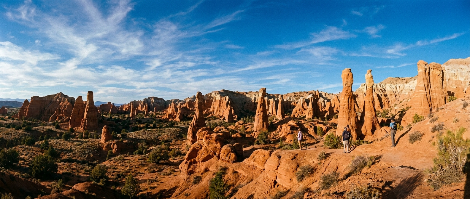
Kodachrome Basin State Park is the kind of Utah side trip that feels like you discovered it yourself, even though it is hiding in plain sight between Bryce Canyon and the longer hauls toward Kanab, Page, or Zion. The landscape is a scattered skyline of sedimentary chimneys and fins that glow warm peach and rust, especially when the sun drops low.
This guide focuses on Angel’s Palace Trail as the best time-to-payoff hike for a first visit, plus a couple of shorter trails you can slot in if you have extra minutes. I will also cover park fees, the most exposed parts of the day (there is not much shade), and where to point your camera so the rock “pipes” actually look as dramatic as they feel in person.
Quick accuracy note: Trail mileage and elevation are pulled from the current Utah State Parks Kodachrome Basin map and trailhead signage whenever possible. If a sign and a website ever disagree, trust what is posted at the park.
Where it fits
Kodachrome Basin sits just south of the Bryce Canyon area highways, making it a logical stop if you are doing any of these common routes:
- Bryce Canyon to Kanab: Break up the drive with a hike and a different kind of geology than Bryce’s hoodoos.
- Scenic Byway 12: If you are stringing together Bryce, Grand Staircase-Escalante, and Capitol Reef, this is an easy add-on near the Bryce end of the byway.
- Bryce to Page: Kodachrome is a good “move your legs” stop before the longer stretch toward Lake Powell.
Time math you can trust: Kodachrome often works as a 60 to 90 minute detour if the entrance kiosk line is short and parking is smooth. In peak seasons or holiday weekends, add a buffer. If you want to stack a second loop, plan 2 to 2.5 hours.
Road note: The park is reached via a signed spur that is paved and usually straightforward for standard cars. In winter, early mornings can mean ice. During monsoon downpours, slow down and expect short-lived muddy shoulders and reduced visibility.
Getting there
Quick direction check: From the Bryce Canyon area, you typically reach the park by turning onto Kodachrome Basin Road from UT-12 near the town of Cannonville, then following signs to the state park entrance station. (Signs are clear, but cell service can be spotty, so having an offline map helps.)
Fees and basics
Entrance fee
Kodachrome Basin is a Utah State Park, so it has its own entrance fee structure. Fees can change seasonally and year to year, so treat the posted booth sign as your source of truth. If you are visiting multiple Utah state parks on this trip, a state parks pass can pay off quickly.
Hours
Day-use hours and gate timing can vary by season. Check the official Utah State Parks listing before you go, especially in winter or shoulder season when staffing and daylight can compress your window.
Bathrooms and water
There are restrooms in the park, but on hot days you should assume you will still want your own water in the car and on the trail. Even short hikes are exposed, and the dry air sneaks up on you.
Cell service and navigation
Expect spotty service. Download your maps ahead of time, especially if you are threading a bigger day that includes Bryce viewpoints, Byway 12 pullouts, and a sunset deadline.
Dogs
Dogs are generally allowed in Utah state parks but must be leashed. That said, park-specific restrictions can apply (and rules can differ between trails and developed areas), so confirm current pet rules on the park website and at the entrance kiosk. Bring extra water for them and be realistic about heat and sand.
Horses
Kodachrome has equestrian use on select routes. You are most likely to encounter horses on multi-use trails rather than every short hiking loop. If you do meet riders, give horses the right of way, step to the downhill side if you can, speak calmly, and let them pass before you continue.
Angel’s Palace Trail
If you only do one hike in Kodachrome Basin, make it Angel’s Palace Trail. It is the classic “big views without an all-day commitment” option: you climb to a higher vantage and get a clean read of the basin, the chimneys, and the layered desert beyond.
Trail stats
- Type: Loop (signed loop trail)
- Distance: about 1.6 miles (2.6 km)
- Elevation gain: about 200 to 250 feet (60 to 75 m)
- Difficulty: Moderate (short, but with a steady climb and lots of sun)
- Surface: Dirt and slickrock, with sandy patches
- Trailhead: Angel’s Palace parking area along the main park road (signed)
Source: Utah State Parks map and on-site trail signage. If you track a slightly different number on your watch, that is normal for loops with overlooks and wandering photo pauses.
What it feels like
Think compact desert hiking with a little bit of elevation and a lot of visual reward. The trail keeps opening new angles, and the overlook makes the chimney formations feel like a whole skyline instead of a few isolated towers.
How long to budget
- Hike only: roughly 60 to 90 minutes for most people, depending on photo stops and pacing.
- Full stop including entrance and driving inside the park: often 75 to 105 minutes, longer if the entrance booth or trailhead lot is busy.
Best time of day
Your most comfortable windows are:
- Early morning: cooler temps, softer light, fewer people.
- Late afternoon: warmer light makes the chimneys glow, but watch your turnaround time if you are driving farther that evening.
If you must hike midday, keep it short and efficient: hat, sun shirt, and more water than you think a “quick hike” requires.
Photography angles that work
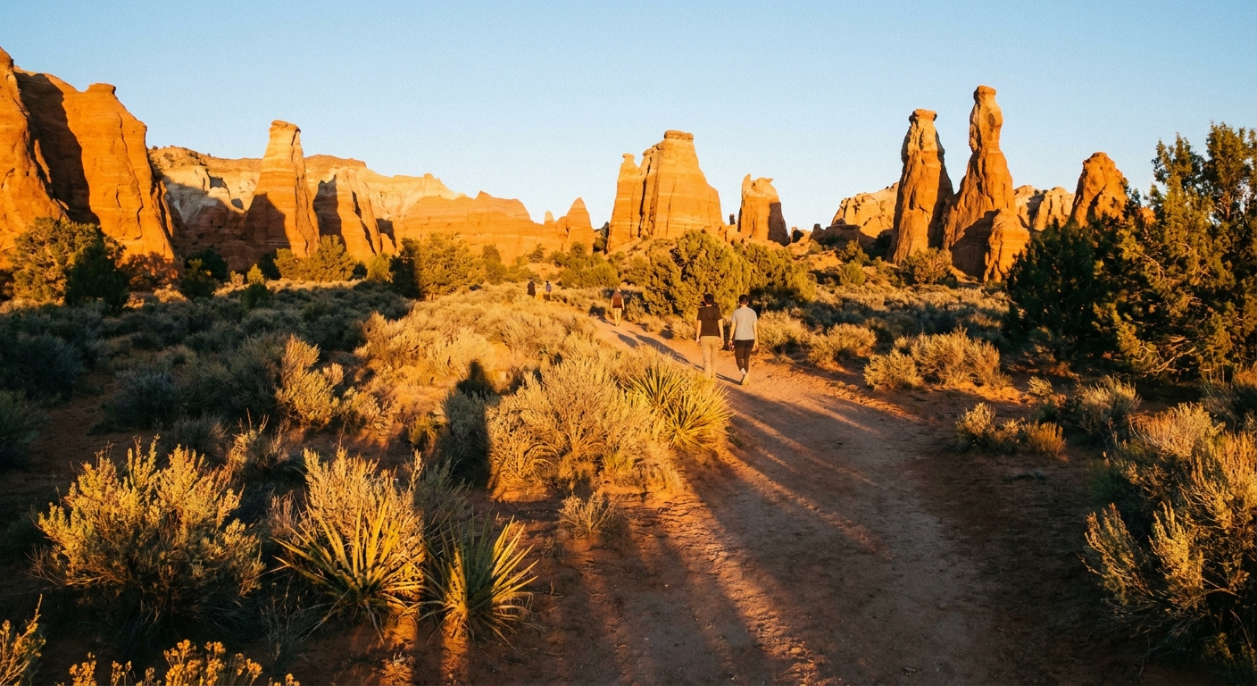
Kodachrome’s chimneys photograph best when you give them either scale or side light.
- Use a person for scale: Place a hiker on the trail in the lower third of the frame so the chimney reads as towering, not just “a tall rock.”
- Chase side light: Early and late sun creates texture on the rock faces. Midday light tends to flatten the formations.
- Shoot low, tilt up: A lower camera angle makes the chimneys look more dramatic.
- Look for layers: From higher points, frame multiple chimneys with the basin behind them for depth.
Two short add-ons
If Angel’s Palace leaves you wanting more, Kodachrome has shorter trails that keep the same “stone pipes” theme without turning your day into a marathon. Always confirm the current names, distances, and any temporary closures on the park map at the kiosk.
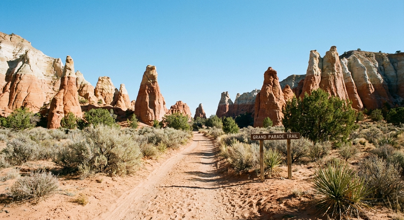
Grand Parade Trail
This is the easy, close-up chimney walk I recommend when you want more formations with minimal effort. It is the kind of trail where you look up a lot, because the spires feel taller from below.
- Type: Out-and-back (signed route)
- Distance: about 1.5 miles (2.4 km) round trip
- Elevation gain: minimal
- Difficulty: Easy
- Time: about 30 to 60 minutes, depending on photo stops and how far you go
- Trailhead: Signed parking area on the main park road
Note: Some visitors connect spurs or stack nearby trails for a longer wander. If you want the simple version, follow the signed out-and-back and turn around at the point that feels good.
Nature Trail
If you want something truly quick, the Nature Trail (interpretive loop near the main day-use area) is the low-commitment option that still delivers classic Kodachrome textures and colors. This is your “we have 20 minutes” win.
- Type: Short loop
- Distance: about 0.25 mile (0.4 km)
- Elevation gain: minimal
- Difficulty: Easy
- Time: about 15 to 25 minutes
- Trailhead: Near the main day-use and picnic areas (signed)
Easy-trail terrain note
Even the “easy” trails here can include sandy stretches and uneven desert tread. These routes are generally not stroller-friendly, and wheelchair access is typically limited to developed areas rather than natural-surface trails. If accessibility is a priority, check with the park directly for the most current options.
How to plan it
Bryce sunrise, Kodachrome, Kanab
- Early: Sunrise viewpoints at Bryce
- Late morning to midday: Drive to Kodachrome, hike Angel’s Palace
- Afternoon: Continue to Kanab for dinner and a comfy bed
Maya’s note: If it is a hot month, I flip this and do Kodachrome earlier, then use Bryce’s higher elevation for the warmer part of the day.
Byway 12 day with a hike
- Morning: Start from the Bryce area
- Mid-morning: Kodachrome for Angel’s Palace or Grand Parade
- Midday to afternoon: Continue onto Scenic Byway 12 for pullouts and longer driving
Only 60 minutes total
- Pay entrance fee (or show your pass)
- Drive to the Angel’s Palace trailhead
- Hike briskly with a few planned photo pauses
- Skip extras and get back on the road
Reality check: This tight version works best off-peak, early in the day, or when the entrance line is empty. If it is a busy weekend, give yourself 90 minutes and you will enjoy it more.
Weather and etiquette
Heat strategy
- Carry water even for short hikes: The dryness is sneaky.
- Sun protection matters: Hat, sunglasses, sunscreen, and a light long sleeve.
- Turn around early if needed: If you are feeling cooked on the climb, you will still get great views from lower vantage points.
Season notes
- Spring wind: Expect gusts and fast-changing comfort levels. A light layer is not optional.
- Winter: Snow and hard-packed mud can linger in shaded spots and make short slopes feel slick. Give yourself more time and wear shoes with real traction.
- Monsoon season: Storms can build quickly. If you hear thunder, get off higher ground and avoid exposed overlooks. Lightning is the bigger risk than the rain.
Leave No Trace basics
- Stay on established trails to protect fragile desert soils and crust.
- Do not climb on formations where posted signs restrict access.
- Pack out all trash, including fruit peels and coffee grounds.
Coffee and stops
I am a firm believer in balancing rugged views with a solid caffeine plan. If you are coming from Bryce, stock up before you leave the Bryce City and Tropic area. If you are continuing toward Kanab, you will have more options for cafes and groceries once you roll into town.
Carry-on only tip: Keep a small cooler bag in the trunk with extra water and a couple of snacks. It turns these short state-park detours into low-stress wins, especially if you are hopping viewpoints and trailheads all day.
Mini checklist
- State park entry fee or pass
- At least 1 liter of water per person for a short hike, more in summer
- Sun protection and a light layer for wind
- Closed-toe shoes (sand and small rocks get everywhere)
- Phone or camera with space for photos, plus an offline map
- Leash and extra water if you bring a dog
Kodachrome Basin is not a “maybe if we have time” stop for me. It is a reliable, high-reward detour that resets your eyes after Bryce’s hoodoo amphitheaters and before the longer drives south. Give it a realistic window, take Angel’s Palace at an unhurried pace, and you will leave with that rare road trip feeling: you found something special between the big-name highlights.