Natural Bridges National Monument: Overlooks, Mesa Top, Easy Hikes
Natural Bridges National Monument is one of those places that makes you wonder how it stays so quiet. Three massive natural bridges (Owachomo, Kachina, and Sipapu), a short scenic drive with overlooks, and just enough hiking to feel like you earned your view without turning the day into an endurance event. If you are road-tripping through southeastern Utah, it pairs beautifully with Bears Ears and Monument Valley vibes, with far fewer crowds and a lot more silence.
The key decision here is simple: do you want to see the bridges from above on the mesa rim, or hike down into White Canyon to stand underneath them? You can absolutely do both, but your knees, your time, and the weather should get a vote.

At a glance: drive vs hike
Natural Bridges is built for casual visitors. The Bridge View Drive is the main event for many people, and it is genuinely scenic. It is typically a one-way rim tour with pullouts and short walks. Hiking down is rewarding, but it is also where heat, steep grades, ladders, and monsoon weather can change the day fast.
- Best for “I want big views with minimal walking”: Bridge View Drive overlooks, especially Owachomo.
- Best for “I want to stand under a bridge”: Kachina and Sipapu via the canyon trails.
- Best for knee-friendly exploring: Mesa Top Trail (as out-and-back), and the short Owachomo trail from its parking area (surface and grade vary).
- Best for photography: Overlooks for wide shots, canyon trails for scale and texture.
- Best for night skies: After-dark stargazing from pullouts, viewpoints, or the campground.
- Quick heads-up about ladders: The notable ladder and stair sections are on the Sipapu route (conditions can change).
Bridge View Drive: overlooks
The paved scenic drive loops past the three primary overlooks. Think of it as a rim tour: expansive canyon views, bridge “windows” cut into stone, and a chance to appreciate how huge these formations are without committing to steep switchbacks.
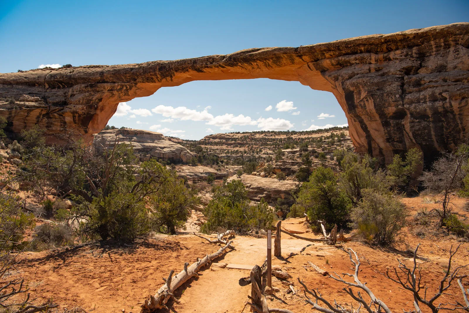
Owáchomo Overlook
If you only stop once, make it Owachomo. The bridge is close to the rim and the walk from the parking area is short, generally the most accessible of the three. It is also the easiest place to get that classic “bridge spanning empty space” view without any serious elevation change.
- Vibe: Big payoff, small effort.
- Good for: Families, older travelers, anyone with tender knees.
- Tip: Late afternoon light can warm the sandstone and make the bridge pop against shadowed canyon walls.
Kachina Overlook
Kachina is a little more removed visually from the rim than Owachomo, but the overlook still gives you a strong sense of depth in White Canyon. If you plan to hike down, this is a helpful preview of what you are getting into.
- Vibe: Dramatic canyon perspective.
- Good for: People deciding whether to hike below the rim.
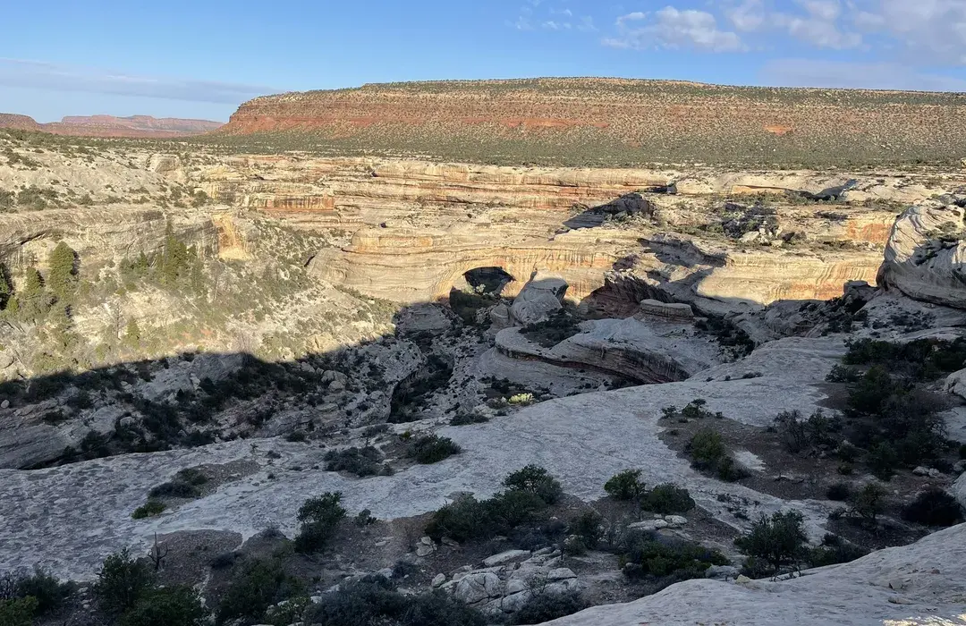
Sipapu Overlook
Sipapu is the largest bridge here, and the overlook lets you appreciate its size from above. It is also a good place to look for layers of geology and sweeping desert scenery.
- Vibe: Grand, wide-open views.
- Good for: Panorama lovers, geology nerds, and anyone who wants the biggest bridge without the biggest hike.
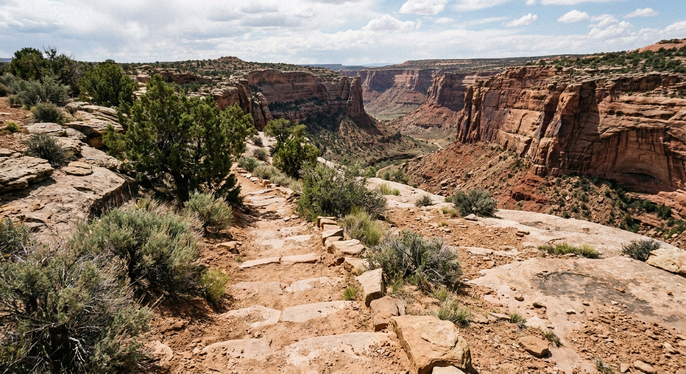
Mesa Top Trail: easy miles
If your ideal day is “walk a bit, see a lot, do not punish my joints,” the Mesa Top Trail is your move. It stays up on the mesa, linking viewpoints and interpretive stops, and it lets you feel like you hiked at Natural Bridges without the steep descent into the canyon.
One important note: people sometimes call this a “loop,” but a true loop usually means dropping into the canyon to connect everything, which is exactly what knee-friendly visitors are trying to avoid. For the flatter option, treat the Mesa Top Trail as an out-and-back from the overlook you are already at. Pick a direction, stroll as far as feels good, then turn around while it still feels good.
- Typical distance: Choose your own. Many people do a short out-and-back (roughly 1 to 3 miles total), but you can go longer if you want.
- Elevation: Mostly gentle rolling terrain on the mesa, with small ups and downs rather than big descents.
- What you will see: Rim scenery, viewpoints, and that big-sky quiet that makes this monument special.
- Footwear tip: Sneakers can work in good conditions, but grippy walking shoes help on rocky sections.
Hikes down: choose wisely
Hiking below the rim is where Natural Bridges shifts from “scenic drive” to “wow, I am in the canyon.” The trails drop into White Canyon and bring you closer to the bridges. Even when distances look manageable, remember that the climb back up can feel bigger in heat and sun.
Distance and elevation vary by route and can shift with reroutes and maintenance, so treat the numbers below as planning ranges and confirm current stats at the trailhead or with a ranger.
Owachomo: easiest taste
Owachomo is typically the most approachable for travelers who want more than an overlook but less than a long, steep canyon day. It is often the best compromise for limited time or knees that do not love long descents.
- Rough effort: Shorter trail than the other two, with a moderate descent and climb back.
- Planning range: About 0.5 to 1 mile round trip, roughly 150 to 250 feet of elevation change.
Kachina: under the span
Kachina rewards you with that classic under-the-bridge perspective. If you are comfortable with uneven terrain and a sustained climb back to the rim, it is a memorable canyon walk.
- Rough effort: Moderate hike with a steady descent and a sweaty return climb.
- Planning range: About 1 to 1.5 miles round trip, roughly 300 to 500 feet of elevation change.
Sipapu: biggest bridge, real obstacles
Sipapu is the heavyweight, and it comes with a very practical detail you should know before you commit: the route often includes steep ladder and stair sections with handrails. They are there to help, but they can feel intimidating if you do not like heights, have balance concerns, or are managing sore knees. These structures and conditions can change with maintenance, so check current status at the overlook or visitor center.
- Rough effort: Longest of the three, and the climb out is real.
- Planning range: About 1.5 to 2.5 miles round trip, roughly 500 to 800 feet of elevation change.
If you are debating between “one canyon hike” and “all three,” choose one bridge hike plus the overlooks. Natural Bridges shines as a savor-it place, not a checklist.
Monsoon risk: canyon safety
This is the part most quick guides skip, and it matters. In summer, southeastern Utah can get monsoon-style storms that build fast. Even if rain is falling miles away, water can surge through narrow drainages and low spots.
Natural Bridges is not marketed like a slot canyon park, but canyon trails and wash crossings still carry flash-flood risk . If you hike below the rim during stormy patterns, you are committing to terrain where escape routes are limited.
How to make a safe call
- Check the forecast for the monument and the wider region: Storms upstream still matter.
- Ask a ranger what conditions have been like: Recent rain and muddy trail sections are a clue.
- Avoid canyon hikes if thunderstorms are predicted: Do the scenic drive and Mesa Top Trail instead.
- Watch the sky, not just your phone: Darkening clouds and sudden wind shifts are your early warning.
- Turn around early: If you hear thunder, prioritize getting out of the canyon.
Outside of monsoon season, the most common challenges are heat, sun exposure, and dehydration. Start earlier in the day if you plan to hike down, and treat every descent as a “pay later” climb.
Dark skies: stay late
Natural Bridges has a brag-worthy claim that still feels a little unreal when you are standing there in the dark: it is widely cited as the first place designated an International Dark Sky Park (designation dates and wording can vary by source, so if your publication supports links, this is a great one to cite directly from the IDA or NPS). Either way, the night skies here are the real headline.
If you can swing it, do not just drive through and leave. Stick around after sunset, let your eyes adjust, and look up.
- What to expect: Big, inky skies, serious stars, and the kind of quiet that makes you whisper without meaning to.
- Easy plan: Finish the overlooks for sunset, then head to a pullout or the campground area for stargazing.
- Tip: Bring a headlamp with a red setting if you have one, and keep white light to a minimum so everyone can keep their night vision.
Itineraries
1 to 2 hours
- Drive the Bridge View Drive loop (usually one-way)
- Stop at all three overlooks
- Do the short Owachomo trail for the most satisfying close view (conditions vary)
Half day
- Bridge View Drive with all overlooks
- Mesa Top Trail as an out-and-back leg-stretcher from your favorite overlook
- Unhurried time at Owachomo for photos
Most of a day
- Start with overlooks to choose your target bridge
- Hike down to either Sipapu or Kachina (budget time and energy for the climb out)
- Finish with the remaining overlooks as a cool-down
Evening add-on
- Sunset at an overlook
- Stargazing from a pullout or the campground area
- Slow drive out, eyes open for wildlife
Logistics
- Fees and passes: Entry fees can change. Check the current fee and pass info on the official NPS Natural Bridges page before you go.
- Hours: The monument is typically open year-round, but weather (snow, ice) and maintenance can affect roads and trail conditions. Confirm current conditions if you are visiting in winter or shoulder seasons.
- Road note: Bridge View Drive is commonly one-way. Plan your stops knowing you cannot just flip around at any point.
- Services: Expect limited services. Do not count on water being available on trails. Bring what you need, especially for canyon hikes.
- Restrooms: Usually available near main developed areas and at some trailheads, but do not assume every viewpoint has them.
- Campground: There is a campground in the monument, which makes the dark sky experience easy. Campground details and seasonality can change, so confirm the current setup and availability on the NPS site.
What to pack
- Water: More than you think, especially if you go below the rim.
- Sun protection: Hat, sunglasses, sunscreen. The canyon reflects light.
- Grippy shoes: Trails can be rocky and slick after rain. Sipapu’s ladder and stair sections are another reason to avoid flimsy soles.
- Light layer: Wind on the rim can surprise you.
- Monsoon-season extra: A weather app, plus the willingness to change plans.
- After-dark extra: Headlamp (red light if possible) and a warm layer for stargazing.
And yes, I always pack a small thermos of coffee for the overlooks. Natural Bridges is a sit-and-stare kind of place, and it is even better with a warm drink and no rush.
When to go
This monument stays quieter than Utah’s headline parks, but timing still helps.
- Best seasons: Spring and fall for comfortable hiking temperatures.
- Summer: Early starts matter, and monsoon afternoons can change plans.
- Best time of day: Morning for cooler hiking, late afternoon for warm sandstone tones at overlooks, and night for the dark sky show.
Accessibility notes
The rim overlooks are generally the most accessible way to experience the monument, but surfaces can still be uneven and grades can vary. Canyon trails are steep, rocky, and not wheelchair accessible. If accessibility is a key factor for your group, check the NPS accessibility details before you go so there are no surprises.
Knee-friendly tips
If knees are the limiting factor, you can still have a fantastic visit.
- Prioritize Owachomo: Short approach and strong views.
- Choose Mesa Top Trail out-and-back over canyon descents: You still get that “I hiked” feeling with less impact.
- Use trekking poles if you hike below the rim: They help on the descent and save energy on the climb back.
- Think twice about Sipapu if ladders are a no: The ladder and stair sections can be a dealbreaker for some bodies, and that is completely fine.
- Go slow: Desert trails reward steady pacing more than speed.
Travel gently
Natural Bridges sits in a culturally and ecologically rich part of Utah, in the broader Bears Ears region, with deep Indigenous connections. Stay on established trails, do not scramble on fragile crusts, and treat viewpoints and canyon bottoms like the living places they are, not just backgrounds for a photo.
If you have extra time, linger at a viewpoint and listen. Then, if you can, linger again after dark and look up. This is one of the best places in the region to remember what quiet actually sounds like.
