North Cascades Highway Pullouts, Short Hikes, and Opening Dates
Maya Lin
Maya Lin is a travel journalist and outdoor enthusiast who believes the best trips combine rugged adventures with urban comforts. After spending six years backpacking across four continents, she founded Trail & Town Guide to help fellow travelers navigate both hidden mountain passes and bustling city neighborhoods with confidence.
The North Cascades Highway (Washington State Route 20) is the rare road trip that feels like a mountain expedition and a scenic Sunday drive at the same time. In a single day you can sip a real espresso in a small town, stare down into electric-turquoise water, and walk a short trail to a high-country overlook. The trick is knowing where to stop, which direction to drive, and when the road is actually open.
This guide focuses on the heart of the drive between Marblemount (west side) and Winthrop (east side), with pullouts that are worth your limited daylight, short hikes that deliver big views, and seasonal planning notes so you do not get surprised by snow gates.
Passes and parking fees
This is a classic North Cascades gotcha: many of the most popular SR 20 trailheads and day-use areas are on federal land and typically require a Northwest Forest Pass or an America the Beautiful (Interagency) pass for parking.
- Common pass-required areas: Rainy Pass and nearby trailheads (like Rainy Lake and Blue Lake) and other signed day-use trailheads along the corridor.
- How to avoid a ticket: Look for fee signage at each lot, display your pass clearly, and do not assume a viewpoint turnout is automatically free.
- Good news: If you already have an Interagency pass, you are usually covered in the same places a Northwest Forest Pass works.
Rules can change by site and managing agency, so treat the sign at the trailhead as the final word.
Seasonal opening and closures
The biggest planning difference on SR 20 versus many other mountain roads is that it regularly closes for winter. WSDOT typically describes the winter closure as being in the high country between the Ross Lake area on the west side and the Silver Star area on the east side. The exact gate locations and mileposts can vary by year and conditions, so it is not worth memorizing a number and getting burned.
Typical schedule (not a promise)
- Winter closure: Often begins after the first sustained snow and avalanche risk, commonly November (sometimes earlier in heavy snow years).
- Spring reopening: Frequently occurs in mid April to early May after avalanche control and plowing.
- Shoulder season reality: Even when the highway is open, expect winter-like conditions at Washington Pass in early spring and late fall.
Always check same-day status before you commit, especially in April, May, October, and November. Start with WSDOT updates for SR 20 North Cascades Highway conditions, seasonal closure status, and traction requirements.
If you are building a whole trip around SR 20, pick a plan A week and a plan B route. The Cascades do not care about your PTO.
Snow and road-risk notes
- Cold mornings: Frost and black ice can linger in shaded corners even after a sunny day.
- Rockfall and debris: Spring melt and rain can trigger small slides. Drive slower than you think you need to in narrow sections.
- No-signal stretches: Download offline maps before you lose service.
- Traction rules: Instead of guessing, check WSDOT traction requirements for the day. In shoulder seasons, it is smart to know the rules for your vehicle and consider carrying chains if conditions call for it.
Services (gas, restrooms, cell)
SR 20 feels wild because, in the middle, it is. Plan like you will not be able to buy anything once you leave town.
- No gas between Marblemount and Mazama: There are no gas stations in the long, scenic stretch between Marblemount (west side) and Mazama (east side). Top off before you commit, even if you think you are “probably fine.”
- Cell service is spotty to nonexistent: Expect long dead zones, especially through the Skagit corridor and the pass areas.
- Restrooms: You will usually find toilets at major trailheads and popular day-use areas (like the main pass trailheads and big viewpoints), but do not count on them being open, stocked, or convenient. Have a backup plan.
- Food and water: Bring enough for the day. Consider it part of the fun, like packing for a mini expedition with a steering wheel.
Best direction to drive
You can drive SR 20 either direction and have a great day, but the stop order changes how the light hits the lakes and peaks, and how busy the classic viewpoints feel.
Driving eastbound (Marblemount to Winthrop)
- Best for: A slow build from rainforest-green valleys to high, rocky passes.
- Light advantage: Morning light often works well for the west-side river and forest scenes. Afternoon light can be nice around Washington Pass depending on cloud cover.
- Flow: You hit Ross Lake and Diablo Lake mid-drive, then finish with the dramatic high country.
Driving westbound (Winthrop to Marblemount)
- Best for: Big views early. You crest Washington Pass quickly and then descend into the lakes.
- Light advantage: Late day can be beautiful for Diablo Lake and the Skagit corridor. Sunset is often better lower down, where the peaks do not block the last light.
- Flow: You can grab early photos at Washington Pass, then treat the lakes as a long golden-hour finale.
If you only have one day and want the iconic photo stops with minimal planning stress, I lean slightly toward westbound for the wow factor early, then an easier descent when you are tired.
Best pullouts and viewpoints
On SR 20, a pullout can mean anything from a two-car shoulder to a full viewpoint with interpretive signs. The list below focuses on spots that reliably deliver. Quick safety note: if it is not a real pullout, keep driving. The shoulders can be narrow and visibility can be rough.
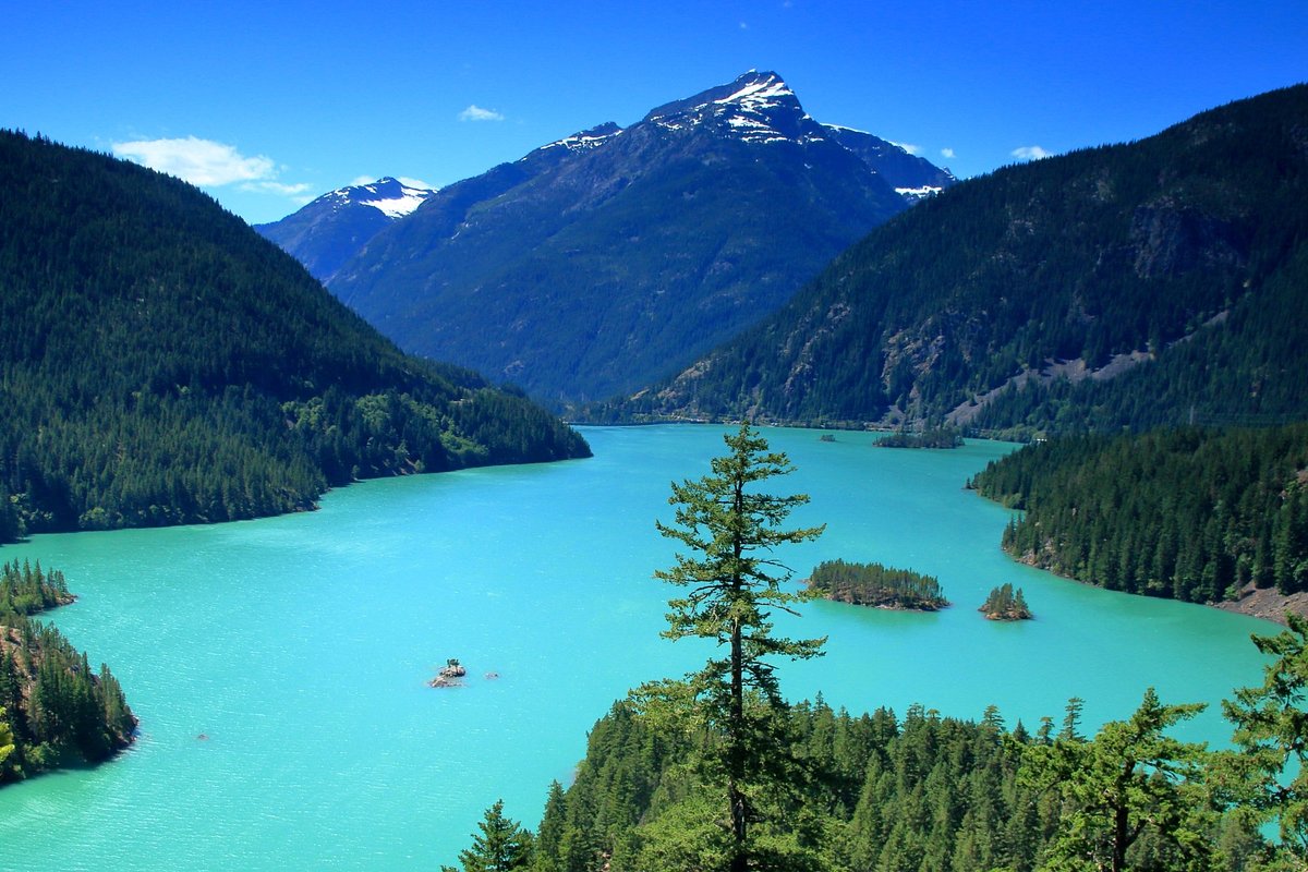
Diablo Lake Vista Point
This is the famous one, and yes, it is worth it. On clear days, the lake glows a surreal turquoise from glacial silt. It is a short, accessible walk from the parking area to the primary overlook.
- Time needed: 15 to 30 minutes
- Best for: Fast, iconic Diablo Lake photos
- Tip: If the main overlook is crowded, linger. Groups cycle through quickly.
Ross Lake glimpses (Skagit corridor)
Ross Lake is long and fjord-like, and you will catch glimpses as the road threads through the Skagit corridor. The magic here is the scale: steep walls, deep water, and a feeling of being far from everything.
- Time needed: 5 to 20 minutes per stop
- Best for: Quick pull over and breathe moments
- Tip: Morning mist in spring and early summer can make the lake feel cinematic.
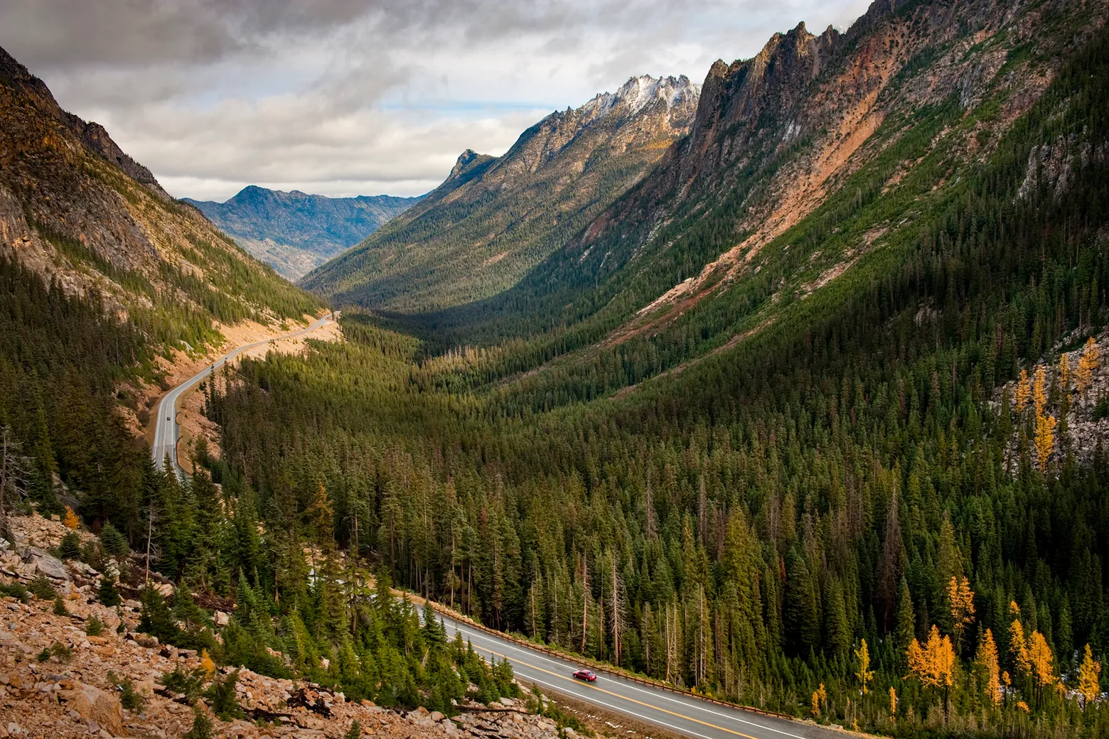
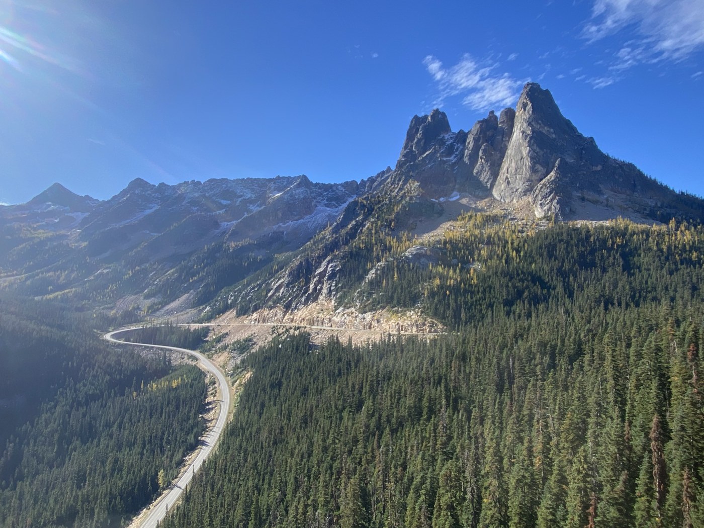
Washington Pass Overlook
If you have time for only one stop besides Diablo Lake, make it this. The overlook trail is short and moderately steep in places, and the payoff is a front-row view of Liberty Bell Mountain and the surrounding spires.
- Time needed: 30 to 45 minutes
- Best for: Big alpine views without a long hike
- Tip: Wind can be intense at the pass. Bring a layer even in July.
Rainy Pass area pullouts
Rainy Pass is less one perfect overlook and more a cluster of opportunities. It is a great place to stretch your legs, check the sky, and decide whether you want a short hike or a longer commitment.
- Time needed: 10 to 30 minutes
- Best for: Quick alpine air, last-minute hike decisions
Short hikes with big payoff
If you are a pullout person, you can still have an incredible day. But if you have the energy for one or two short hikes, SR 20 rewards you fast. (Heads up: these popular trailheads often require a Northwest Forest Pass or an Interagency pass. Check the sign at the lot.)
Rainy Lake (easy)
A mellow trail to a lovely mountain lake. This is an excellent choice if you are traveling with kids, new hikers, or anyone who wants maximum scenery for minimal effort.
- Vibe: Accessible, calm, reflective water and mountain walls
- When to go: Earlier in the day for fewer people and smoother parking
Washington Pass Overlook Trail (short)
Technically more viewpoint walk than hike, but it earns its place. If clouds are moving fast, wait a few minutes. The scene changes constantly up here.
- Vibe: Alpine drama on a tight schedule
- When to go: Early morning for crisp light and lighter crowds
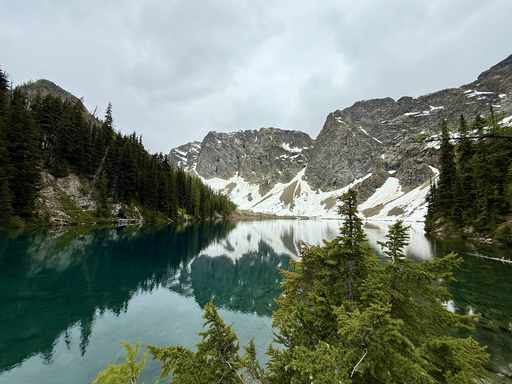
Blue Lake (moderate)
Blue Lake is the step up. It is not a quick leg-stretcher, but it is still doable as a half-day outing if you are basing in the area. The lake is famously clear, set in a bowl of cliffs and peaks.
- Vibe: A real hike with a true destination
- Good to know: Trail conditions can hold snow early season. If you see fresh snow at the pass, expect it on-trail too.
Viewpoints vs longer hikes
People ask me all the time whether Diablo Lake is better from the vista point or from a longer trail. They are different experiences.
Choose viewpoints if you want
- Maximum scenery per minute, especially on a one-day road trip
- Reliable access without worrying as much about snow on trail
- Flexibility to chase light and weather across the highway
Choose longer hikes if you want
- Solitude once you get past the first mile or two
- Depth like quiet forest sections, wildflowers, and layered viewpoints
- A sense of earning it, which is very North Cascades in spirit
My sweet spot for most travelers is a hybrid day: two major viewpoints (Diablo Lake Vista and Washington Pass Overlook) plus one short lake hike (Rainy Lake) if parking and energy allow.
Photo timing
The North Cascades are moody. Sun, haze, and cloud can change the same viewpoint from jaw-dropping to flat in ten minutes. A little timing strategy helps.
General timing tips
- Early morning: Calmer wind, fewer people, cleaner views before heat haze.
- Midday: Works surprisingly well in deep valleys and forest scenes. High-alpine overlooks can feel harsh.
- Golden hour: Great for warm mountain tones, but note that some overlooks can fall into shadow as the sun drops behind peaks.
When Diablo Lake looks dull
If the turquoise is not popping, it is often because of flat light or smoke haze. Wait for a sun break, or pivot to texture shots: the surrounding peaks, the forest layers, or closer compositions that do not rely on color alone.
When Washington Pass is socked in
Do not immediately bail. I have watched the overlook go from zero visibility to full Liberty Bell reveal in a five-minute window. Pack a warm layer, sip some coffee, and give the clouds a chance to perform.
Suggested stop order
These are flexible frameworks. The best itinerary depends on your start time, the season, and whether you want more steering-wheel time or more trail time.
Option A: Eastbound (Marblemount to Winthrop)
- Start: Marblemount area, top off gas and grab snacks
- Skagit corridor: Short Ross Lake glimpses and pullouts as you go
- Diablo Lake Vista Point: Your first big photo stop
- Rainy Pass: Decide on Rainy Lake or keep it scenic-only
- Washington Pass Overlook: Capstone views
- Finish: Winthrop for dinner, shower, and a real bed
Option B: Westbound (Winthrop to Marblemount)
- Start: Winthrop or Mazama, early coffee and an early start
- Washington Pass Overlook: Big alpine views while legs are fresh
- Rainy Lake: Easy hike break before the long descent
- Diablo Lake Vista Point: Set aside time to wait for a sun break
- Skagit corridor: Slow roll the last scenic stretches
- Finish: Marblemount and onward toward Burlington or Seattle
Road-trip essentials (minimalist)
This is my minimalist packing list for a one-day or weekend SR 20 run, especially in shoulder seasons.
- Layers: Light puffy or fleece, plus a rain shell
- Footwear: Grippy shoes, trails can be damp or snowy near the passes
- Food and water: Enough for delays and slow scenic wandering
- Offline navigation: Download maps and key pins before you lose signal
- Car basics: Full tank, windshield cleaner, and a physical map if you like old-school backups
- Pass for parking: Northwest Forest Pass or America the Beautiful pass (plus a way to display it)
- Leave No Trace kit: Small trash bag, plus a plan for bathrooms between towns
Quick FAQ
How long does it take to drive the North Cascades Highway?
Pure drive time from Marblemount to Winthrop is usually around 3 hours in good conditions. To do it right with viewpoints, short hikes, and photo stops, most travelers should plan a full day (often 6 to 10 hours depending on how hike-happy you are).
Is it worth it if I cannot hike?
Absolutely. Diablo Lake Vista Point and Washington Pass Overlook deliver top-tier scenery with minimal walking.
What is the most common planning mistake?
Underestimating seasonal closures and assuming SR 20 is open like a typical highway year-round. The second most common mistake is starting too late and rushing every stop.
Final note
The North Cascades feel wild because they are. Stay on trails, keep your wheels in designated pullouts, pack out everything, and give wildlife and other travelers space. Your best photos will come from patience, not proximity.