Saguaro National Park East vs West: Best Day Hikes Near Tucson
Maya Lin
Maya Lin is a travel journalist and outdoor enthusiast who believes the best trips combine rugged adventures with urban comforts. After spending six years backpacking across four continents, she founded Trail & Town Guide to help fellow travelers navigate both hidden mountain passes and bustling city neighborhoods with confidence.
Saguaro National Park is the rare place where your “big desert day” can start with a sunrise hike among towering cacti and still end with tacos, a cold drink, and a real bed in Tucson. The park is split into two districts that sit on either side of the city: Rincon Mountain District (East) and Tucson Mountain District (West). Same iconic saguaro silhouettes, totally different feel.
If you only have one day, this guide helps you pick the right side (or stitch together both) based on photo stops, trail difficulty, and the reality of desert heat.
East vs West at a glance
Think of Saguaro East as bigger, higher, and more “mountain-meets-desert.” Think of Saguaro West as denser with saguaros, closer to the city, and unbeatable for short, scenic hikes and sunset light.
| What you care about | Saguaro East (Rincon) | Saguaro West (Tucson Mountain) |
|---|---|---|
| Best overall vibe | Quieter, more expansive, more rugged | Classic saguaro “forest,” very scenic, easy access |
| Scenic drive | Cactus Forest Drive (paved) | Bajada Loop Drive (part paved, part unpaved) |
| Signature scenery | Saguaros with Rincon peaks and wide views | Dense saguaros with sunset light and volcanic rock |
| Quick hikes | Good, but trailheads are more dispersed (more driving between them) | Excellent, lots of hits in 1 to 3 miles |
| Longer hikes | More options and bigger elevation gains | Limited, but some solid moderate-to-strenuous options |
| Best time of day | Early morning | Late afternoon into sunset (when temps allow) |
Quick logistics
- From downtown Tucson: plan roughly 20 to 35 minutes to most West-side trailheads and 25 to 45 minutes to most East-side trailheads, depending on traffic and where you start.
- East to West across town: budget 45 to 75 minutes for the drive, plus extra time around rush hour.
- Visitor centers: hours vary by season and can change. Check the official NPS site the day you go if you are timing water refills or bookstore stops.
- Sunset: winter sunsets come early. If you want a sunset hike, start earlier than you think, especially in November through February.
Signature photo stops
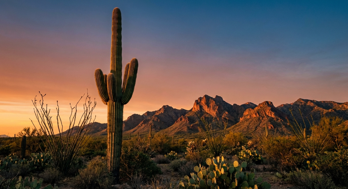
Saguaro East: Cactus Forest Drive
Cactus Forest Drive is a gorgeous, paved loop with frequent pullouts. It is my favorite “easy win” for first-timers because you can stack a hike, photos, and a picnic without extra logistics.
- Cactus Forest Overlook: A classic wide-angle view with saguaros stepping down into the valley and mountains behind.
- Desert Ecology Trail area: Great for close-up saguaro portraits and warm morning light.
- Javelina Rocks pullouts: Big boulder backdrops that make saguaros look extra dramatic.
Photo note: East tends to shine at sunrise and early morning when the Rincon backdrop looks crisp and the air feels calmer.
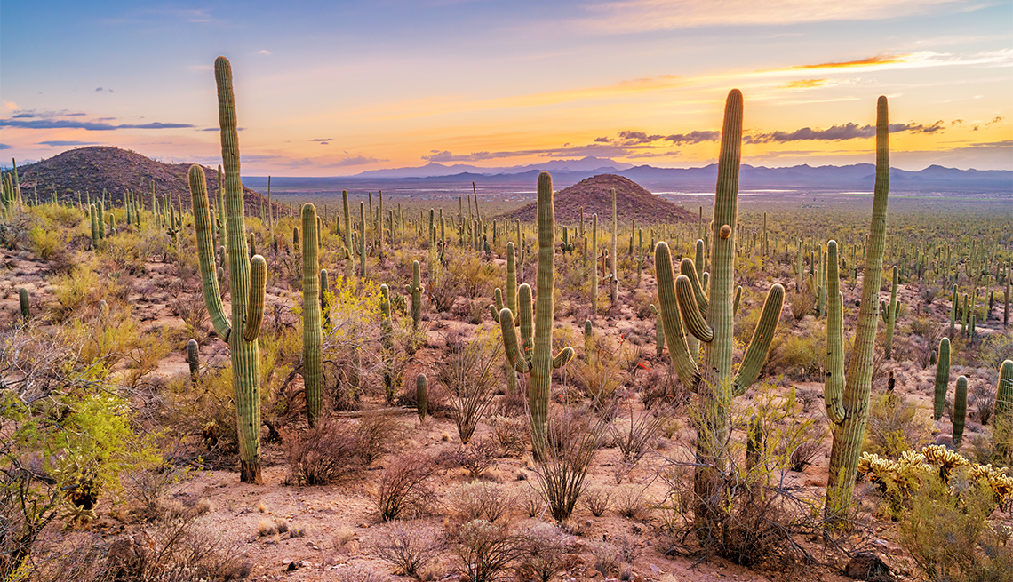
Saguaro West: Bajada Loop Drive and Gates Pass nearby
In the west district, saguaros feel packed in, almost like they are competing for space. Add in dark volcanic rock and the way the sun drops behind the Tucson Mountains, and you get seriously photogenic desert scenes right next to a major city.
- Bajada Loop Drive pullouts: Look for layers of cactus with the road curving away behind them.
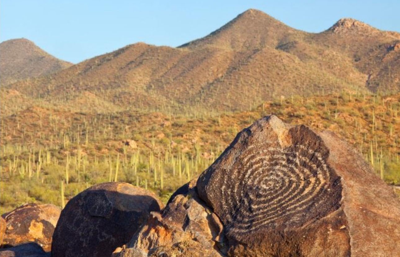
- Signal Hill: Short walk to petroglyphs and a higher perch for saguaro-filled horizons.
- Gates Pass (just outside the park): A famous Tucson sunset stop with big skies.
Road note: Bajada Loop includes an unpaved section that is often manageable in a regular car when dry, but conditions can change fast after storms. Slow down, and check current NPS alerts if rain is in the forecast.
Best day hikes
Trail conditions change with weather and maintenance, so confirm current status with the National Park Service before you go. Distances and elevation below are typical, and your exact mileage will vary based on the turnaround or loop you choose.
Difficulty bands
- Easy: Mostly flat or gently rolling, typically 0 to 3 miles. Good for families, jet-lagged travelers, and midday winter strolls.
- Moderate: 3 to 7 miles with some sustained climbing or rocky tread. Most popular “see a lot” hikes land here.
- Hard: 7+ miles, big elevation gain, longer water carry, and less shade. Best in cooler months.
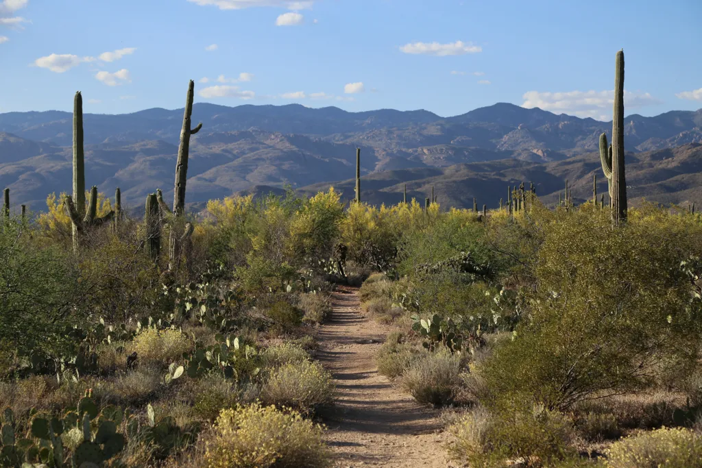
Saguaro East hikes
Easy: Desert Ecology Trail
Stats: about 0.25 miles round trip, minimal elevation, 10 to 20 minutes.
A short, interpretive walk that is perfect if you want a “first saguaro” moment without committing to a long hike. Go early and you will catch crisp light and fewer people.
Moderate: Loma Verde to Saguaro Vista
Stats: roughly 3 to 6 miles depending on route, about 400 to 900 feet of gain, 2 to 4 hours.
This is one of the best ways to earn a view in the east district without turning your day into a full-on sufferfest. Expect classic Sonoran plants, big cactus stands, and a viewpoint that feels like it was designed for a snack break.
Hard: Tanque Verde Ridge (turnaround hike)
Stats: common day-hike turnarounds land around 8 to 14 miles with 1,500 to 3,000+ feet of gain, 5 to 9 hours.
If you are craving elevation and big horizons, head toward Tanque Verde Ridge and turn around based on time, heat, and water. This is a strong training-hike option with serious sun exposure.
Saguaro West hikes
Easy: Signal Hill Trail
Stats: about 0.3 miles round trip, minimal elevation, 15 to 30 minutes.
Short, scenic, and genuinely interesting because of the petroglyphs. It is a great add-on to Bajada Loop Drive, especially if you are traveling with mixed energy levels.
Moderate to hard: King Canyon to Hugh Norris (turnaround hike)
Stats: as an out-and-back, expect roughly 3 to 10+ miles and 600 to 2,500+ feet of gain depending on how far you go, 2 to 7 hours.
This is a choose-your-distance hike that can stay moderate if you turn around early or become a bigger effort if you push higher. The saguaros feel endless here, and the views open fast.
Easy: Valley View Overlook Trail
Stats: about 0.8 miles round trip, minimal elevation, 30 to 60 minutes.
A favorite for sunset hikers. The trail is short enough to fit into an evening plan, and the overlook is a natural spot to watch the desert shift from gold to pink to purple.

Heat and weather
Tucson’s desert heat is not a vibe, it is a variable you plan around. In warm months, your limiting factor is usually sun exposure and water, not your fitness.
Best seasons for longer hikes
- Late fall through early spring: Prime time for moderate and hard hikes, plus comfortable scenic drives.
- Late spring and summer: Stick to very early starts and shorter routes. Consider sunrise hikes and then retreat to Tucson for museums, coffee, and shade.
Monsoon heads-up
- Flash floods: Wash crossings can flood quickly even if it is not raining where you are standing.
- Lightning: If storms build, ridgelines and exposed overlooks are not where you want to be.
- Muddy roads: The unpaved section of Bajada Loop can get slick after rain. If it looks questionable, skip it.
Desert-day rules I actually follow
- Start early: Aim to be walking at dawn in hot weather.
- Carry more water than you think: You can usually find potable water at visitor centers and some developed areas during open hours, but do not count on water once you are out on the trail. A hydration bladder plus an extra bottle is my default.
- Electrolytes are not optional: Salty snacks or electrolyte mix prevents the classic “I feel weird” desert bonk.
- Sun protection: Wide-brim hat, sunscreen, and light long sleeves can feel cooler than a tank top.
- Watch for wildlife: Give rattlesnakes space and keep eyes on the trail edges.
Slow travel tip: build your day like a desert animal. Move at dawn and dusk, rest mid-day. Tucson has excellent coffee and air conditioning for a reason.
If you only have 2 to 3 hours
Fast West plan
- Drive: Do a portion of Bajada Loop Drive with a few quick pullouts.
- Walk: Signal Hill Trail for petroglyphs and a wide view.
- Optional: If it is late day and temps allow, swap Signal Hill for Valley View Overlook.
Fast East plan
- Drive: Cactus Forest Drive plus Cactus Forest Overlook.
- Walk: Desert Ecology Trail for an easy, close-up cactus experience.
Photographer notes
- Best light: East tends to photograph best at sunrise; West tends to glow at late afternoon and sunset.
- Lenses: A wide lens for big saguaro landscapes, plus a short telephoto for layering cactus against mountains and isolating shapes.
- Pullout etiquette: Use designated pullouts, watch traffic, and keep feet off fragile plants. The best shot is never worth trampling the desert.
One-day plan
If you want a relaxed, high-reward day, choose one side. You will spend less time driving across town and more time in the landscapes you came for.
Best one-day in Saguaro West (my pick for first-timers)
- Morning: Drive in early, hike King Canyon as far as feels good.
- Late morning: Cruise Bajada Loop Drive and stop for photos.
- Midday: Head back to Tucson for lunch and a long shade break.
- Late afternoon: Short hike to Valley View Overlook if temperatures allow.
- Sunset: Finish at Gates Pass nearby for big sky color.
Best one-day in Saguaro East (quieter, more spacious)
- Morning: Do the Loma Verde area hike (pick a loop or out-and-back).
- Late morning: Drive Cactus Forest Drive, stopping at overlooks.
- Midday: Picnic in a shaded spot when you find one, then head back to Tucson.
- Afternoon: Optional easy stroll on Desert Ecology Trail if it is cool enough.
Two-half-day plan
This is my favorite way to do Saguaro if you have one night in Tucson. You get the best light on both sides and you avoid the temptation to cram in too much midday hiking.
Half-day 1 (sunrise): Saguaro East
- Dawn hike: Loma Verde area for cooler temps and soft light.
- Post-hike: Cactus Forest Drive viewpoints for photos.
- Late morning: Back to town for brunch and coffee.
Half-day 2 (late afternoon to sunset): Saguaro West
- Late afternoon hike: Signal Hill and/or Valley View Overlook.
- Golden hour drive: Bajada Loop Drive for that classic saguaro glow (if road conditions are good).
- Sunset: Gates Pass nearby if you want a final, dramatic skyline.

Which district should you choose?
Pick Saguaro East if you want
- More of a mountain backdrop and a spacious feel
- Longer hikes with the option to gain elevation
- A quieter experience, especially early
Pick Saguaro West if you want
- The densest “saguaro forest” vibes and dramatic sunset light
- Short-to-moderate hikes that pair well with a scenic drive
- Easier logistics from central Tucson
If you are torn, the two-half-day plan solves it. One sunrise in the east, one sunset in the west, and Tucson in the middle for the comforts that make desert travel feel sustainable and fun.
Accessibility and family notes
- Easy, low-commitment walks: Desert Ecology Trail (East), Signal Hill Trail (West), and Valley View Overlook (West) are all short and popular for mixed groups.
- Scenic drives for limited mobility days: Cactus Forest Drive (East) is fully paved; Bajada Loop (West) is a mix of paved and unpaved, so it is best when roads are dry.
- Strollers and wheels: Desert trails are often uneven and sandy. If you need a truly smooth surface, check current NPS accessibility info for paved paths and visitor center areas.
Know before you go
- Fees and passes: Entry fees apply. An America the Beautiful pass can be a good deal if you are hitting multiple parks.
- Road surfaces: Some West-side driving is on unpaved road. It is often fine for standard cars when dry, but slow down and avoid after heavy rain.
- Water: Fill up in developed areas and visitor centers during open hours. On-trail water sources are not something to plan around.
- Leave no trace: Stay on trail, do not touch petroglyphs, and pack out all trash, including food scraps.
- Respect saguaros: They grow incredibly slowly and are protected. Keep a little distance, especially for photos.