Saguaro National Park Scenic Driving Loops
Saguaro National Park is one of those rare places where you can have a wow-worthy desert day without committing to a big hike. You can roll the windows down, follow a loop road through a forest of saguaros, and hop out for short, satisfying walks that feel like mini adventures.
The park has two separate districts on opposite sides of Tucson: Saguaro West (Tucson Mountain District) and Saguaro East (Rincon Mountain District). They look similar at a glance, but the driving experience, road surfaces, and the best pullouts are different enough that it helps to plan ahead.

Quick reality check: Treat these as scenic drives with short walks, not full-service road trips. Cell coverage can be spotty, summer heat is serious, and water is not always available at every stop.
West vs East
If you only have time for one loop, choose based on your vehicle, the kind of scenery you want, and the time of day you can go.
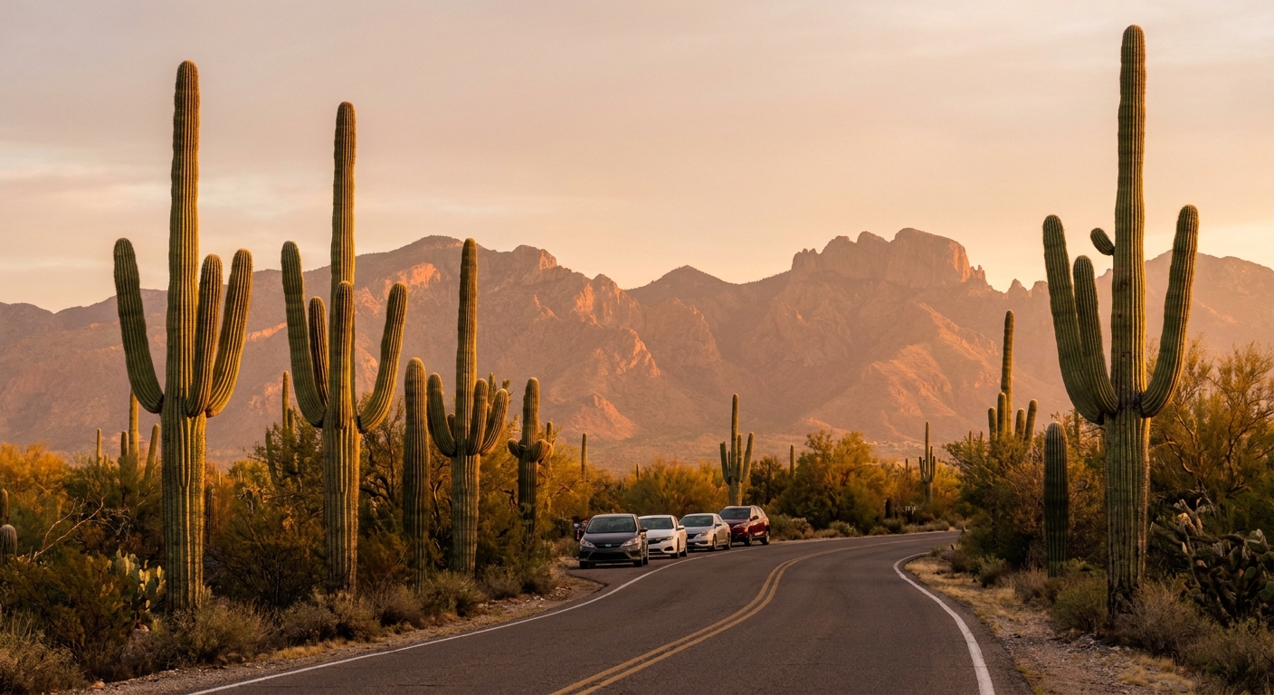
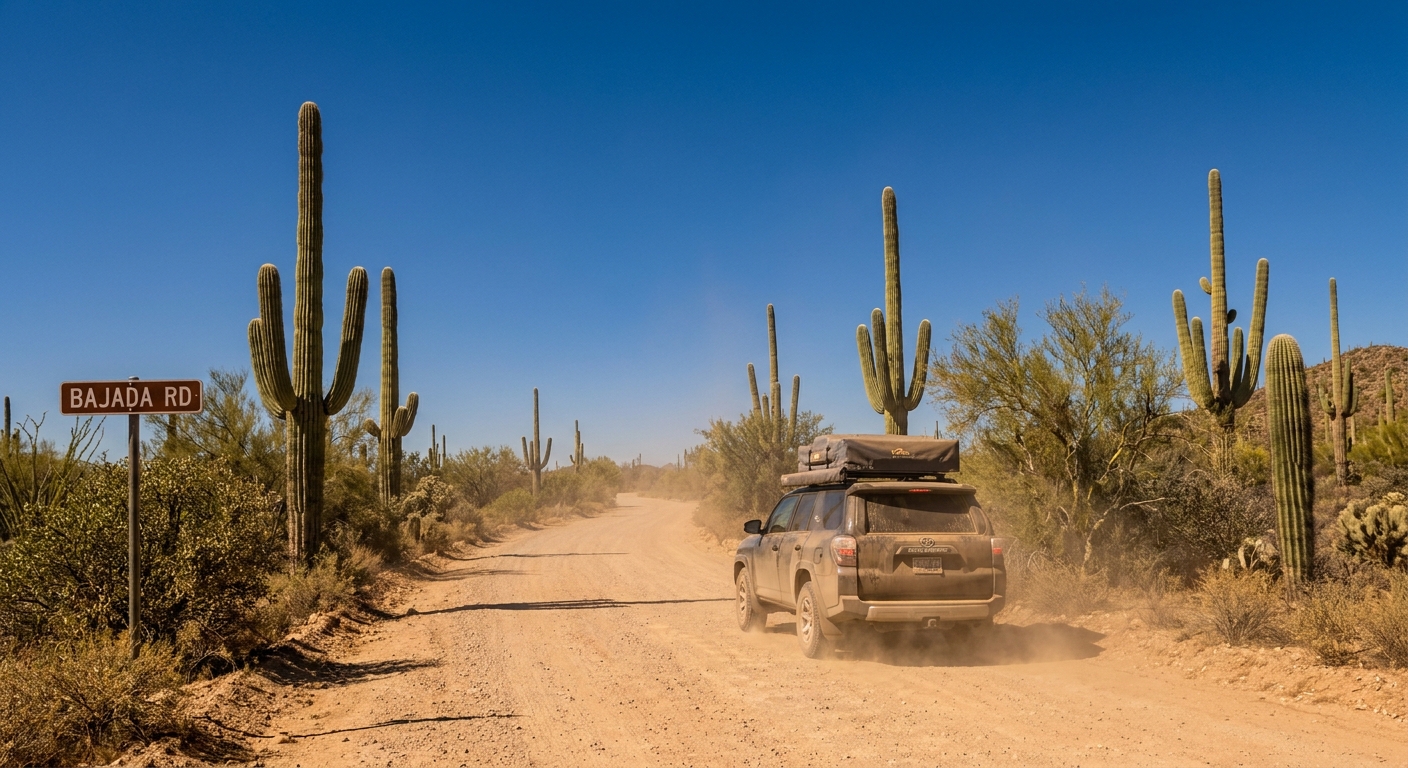
- Saguaro West (Tucson Mountain District): Bigger “cactus everywhere” feeling, more dramatic sunset vibes, and one key road segment that is unpaved (Bajada Road). Great if you like the idea of a slower, dustier desert drive with frequent places to pull off.
- Saguaro East (Rincon Mountain District): Classic paved loop (Cactus Forest Drive) with lots of signed pullouts and short trails. Excellent for rental cars, first-timers, and anyone who wants an easy, polished scenic drive.
How far apart?
The two districts are not connected inside the park. Driving from one visitor area to the other through Tucson usually takes 45 to 75 minutes depending on traffic and where you start.
Saguaro West loop
Saguaro West feels rugged in the best way: desert foothills, dense saguaro stands, and a road that encourages you to slow down and actually look. The signature drive here is a loop that combines paved and graded dirt road.
Route basics
- Main loop: The classic loop uses a mix of paved roads and the unpaved Bajada Road, typically linked with Hohokam Road and Golden Gate Road (names and exact connectors can vary by map, but Bajada is the dirt section most people mean when they say “the West loop”).
- Distance: Roughly 10 to 12 miles depending on which connectors and pullouts you include.
- Time: 1.5 to 3 hours with stops and one or two tiny walks.
- Road surface: Expect pavement plus graded dirt. Usually passable in a standard car when dry, but avoid after heavy rain and drive slowly to reduce dust and washboard shake.
- Direction: One-way. The main Bajada Loop Drive is signed as one-way for motor vehicles. Follow posted NPS traffic flow and do not plan on “doing it backwards.”
Where you can legally stop
In Saguaro West, many pullouts are informal. Use a simple rule: only stop where your entire vehicle is fully off the roadway in a clearly worn pullout or signed parking area. Do not create new roadside “parking” by crunching vegetation or pulling onto fragile desert soil.
- Good signs: packed gravel pullouts, rock edging, a visible parking spur, trailhead signs, or an established lot.
- Skip it if: the shoulder is narrow, you would block traffic, you would have to park on plants, or you are tempted to “just fit” partially in the lane.
Tiny walks (10 to 30 minutes)
These are perfect if you want more than a photo from the car but less than a sweaty commitment.
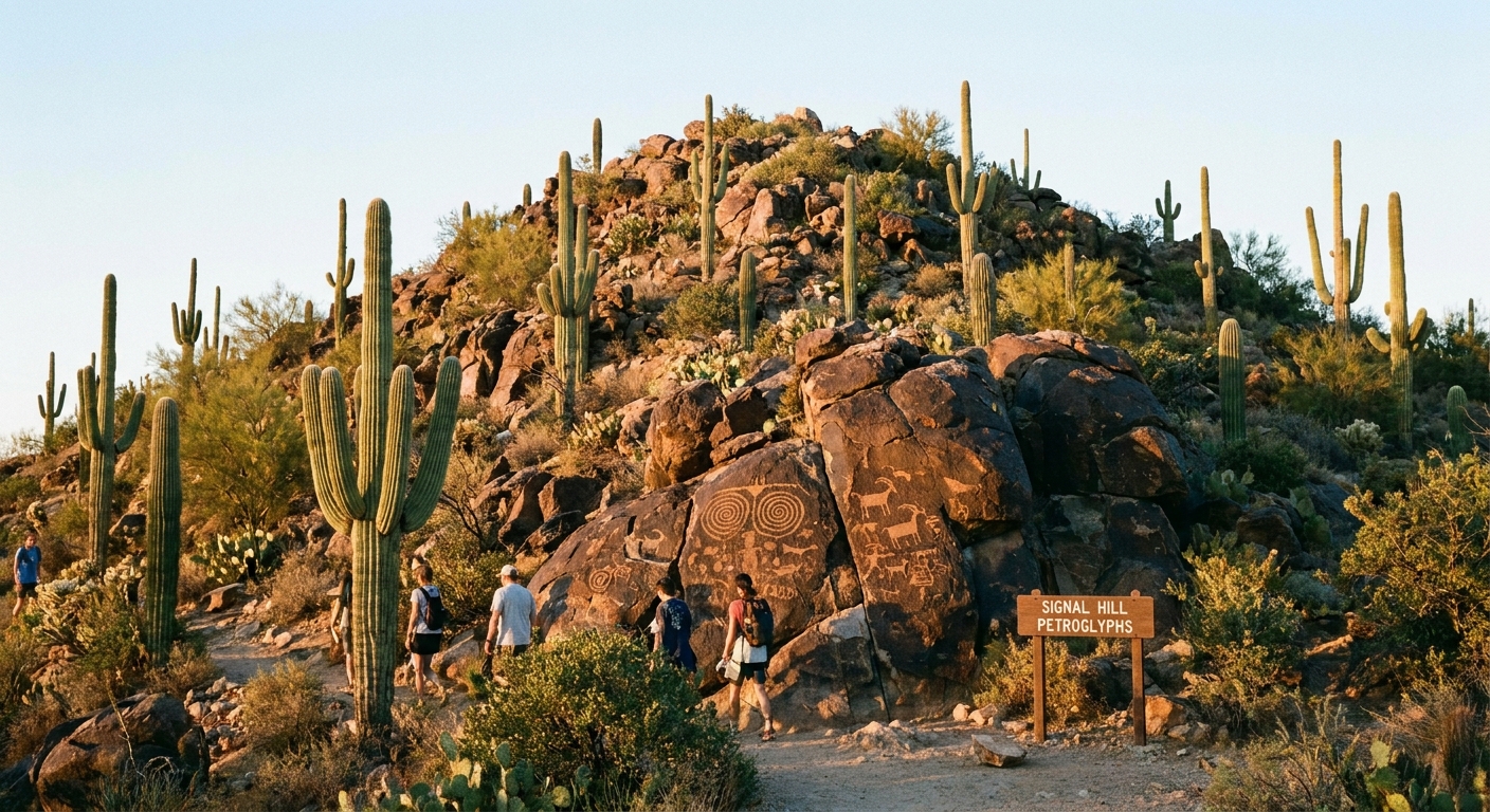
Signal Hill Petroglyphs
Time: 15 to 30 minutes round trip depending on how long you linger. Why stop: A short walk leads to a rocky hill with petroglyphs and a sweeping view across the cactus-covered plain. It is one of the best effort-to-reward stops in the entire park.
Tip: The rocks can feel slick in worn spots. Good shoes beat flip-flops here.
Desert Discovery Trail
Time: 15 to 25 minutes. Why stop: Easy, interpretive, and great if you want a low-key walk with close-up cactus viewing and context about how this ecosystem actually works.
Short nature strolls from established pullouts
Time: 10 to 20 minutes. Why stop: On the loop you will find a handful of established pullouts where you can step away from the road, walk a few minutes into the wash or along a faint use path, and suddenly the road noise disappears. Keep it gentle and stay mindful of cryptobiotic soil and seedlings.
Restrooms and water
- Restrooms: Your best bet is near the visitor center area and major developed sites. On the loop itself, restrooms are not guaranteed at every stop.
- Water: Do not count on refill stations being available away from the main developed areas. Bring your own water in the car, even for short walks. In warmer months, a “scenic drive” can quietly turn into a dehydrating afternoon.
When the West shines
Saguaro West is fantastic for late afternoon and sunset because the lower mountains and dense cactus stands catch warm light beautifully. In spring, you may spot patches of wildflowers along the roadside and in open flats. The show changes year to year, so think of blooms as a bonus, not a promise.
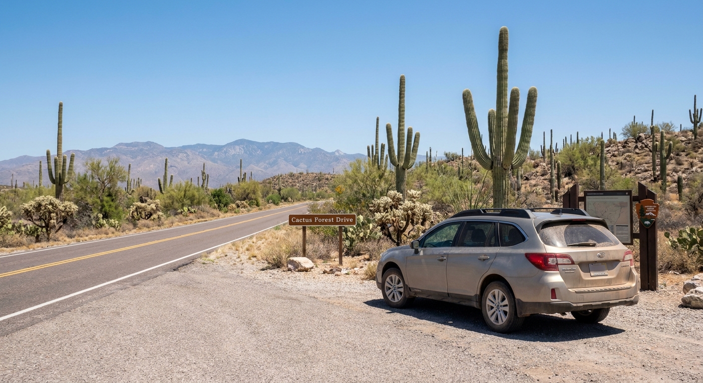
Saguaro East loop
Saguaro East is the smooth, classic scenic loop many visitors picture: a paved road curling through tall saguaros with the Rincon Mountains rising behind them. It is easy to drive, easy to stop, and full of quick walks that feel far from the city.
Route basics
- Main loop: Cactus Forest Drive
- Distance: About 8 miles for the loop, plus short spurs to viewpoints and trailheads.
- Time: 1.5 to 2.5 hours with pullouts and one short walk.
- Road surface: Fully paved.
- Direction: One-way. Cactus Forest Drive is a one-way scenic loop for motor vehicles. Plan your time and stops around the posted direction since you cannot legally reverse course to “catch” a pullout you missed.
Best pullouts for tiny walks
East is pullout-friendly. Many stops have clear parking areas and signed trail access. Here are a few reliable options when you want a 10 to 30 minute leg-stretcher.
Javelina Rocks area
Time: 15 to 30 minutes. Why stop: Big boulders, classic cactus scenery, and short paths where you can wander without committing to a long hike. This is a great “get out, feel the desert, take photos, move on” stop.
Desert Ecology Trail
Time: 15 to 30 minutes. Why stop: A short interpretive loop that makes the landscape feel more alive once you know what you are looking at. Expect easy walking and excellent close-up plant spotting.
Freeman Homestead Trail
Time: 20 to 30 minutes. Why stop: A quick walk with a sense of history and a different feel than the pure cactus vistas. It is a nice change of pace if you have already done a few scenic pullouts.
Viewpoint pullouts
Time: 10 to 20 minutes. Why stop: Some pullouts are pure “stretch and stare.” Hop out, walk a minute or two away from the car, and you will often find better angles and quieter moments than the immediate roadside.
Where to legally stop
Stick to designated pullouts and signed parking areas along Cactus Forest Drive. They exist for a reason: visibility, safety, and protecting the desert shoulder. If a pullout is full, keep going. Another one is usually minutes away.
Restrooms and water
- Restrooms: More predictable near developed areas and popular trailheads, less so at random pullouts.
- Water: Plan as if you will not find water on the loop. Even when facilities exist, availability can change with maintenance and season.
Season notes
Spring is the star for many visitors. Depending on rainfall and timing, you might catch wildflowers in the lower areas and see saguaros beginning their bloom cycle later in spring into early summer. If you are planning your trip around peak bloom timing, treat this drive as the perfect companion to a bloom-focused plan rather than a replacement.
Pick your loop
- You have a rental car and want easy logistics: Choose Saguaro East and do Cactus Forest Drive with one short interpretive trail.
- You want a more rugged, slower desert feel: Choose Saguaro West and include Bajada Road if conditions are dry.
- You are photographing sunrise: East often gives you a beautiful mountain-backed glow, especially with clear air.
- You are photographing sunset: West is hard to beat for warm light across dense saguaro stands.
- You are traveling with kids or anyone heat-sensitive: Either works, but plan for shorter stops, bring extra water, and prioritize developed areas for restroom breaks.
Safety basics
These loops are mellow, but the Sonoran Desert does not care if you only planned to be outside for 15 minutes.
- Carry more water than you think you need. Keep a dedicated car stash for unexpected delays.
- Start early in warm months. Midday heat on pavement is intense and radiates back up at you.
- Watch your step. Cholla segments, spines, and loose rock are common right off the shoulder.
- Do not feed wildlife. It is unsafe for you and harmful for them.
- Stay on established paths where possible. Desert soil and plants recover slowly.
If you are building a full Tucson day around a scenic loop, I like this rhythm: coffee in town, drive the loop with two to four pullouts and one interpretive trail, then finish with a late lunch back in Tucson where air conditioning and cold drinks feel like a reward you earned.
FAQ
Can I do both loops in one day?
Yes, if you keep your walks short and accept that you will be in the car a fair amount. A common approach is one district in the morning, a break in Tucson midday, then the other district late afternoon.
Is Bajada Road okay for sedans?
Often, yes when conditions are dry and recently graded, but it can be washboarded or rutted. Drive slowly, avoid it after heavy rain, and do not force it if you are uncomfortable. There is plenty to see on paved roads too.
Do I need a reservation?
Generally, no reservation is needed for these drives, but you will need to follow current park entry requirements and pay an entrance fee or use a park pass. Check the National Park Service site before you go for any temporary road closures or construction updates.