Salt Lake City Day Hikes: Easy Wasatch Starters From the Valley
Maya Lin
Maya Lin is a travel journalist and outdoor enthusiast who believes the best trips combine rugged adventures with urban comforts. After spending six years backpacking across four continents, she founded Trail & Town Guide to help fellow travelers navigate both hidden mountain passes and bustling city neighborhoods with confidence.
Salt Lake City has a rare superpower: you can eat a downtown brunch, grab a genuinely good latte, and be on a mountain trail before your pancakes settle. The Wasatch rises fast from the valley, which is great for quick nature hits, but it also means weather swings, crowded trailheads, and surprise snow patches can show up when you least expect them.
This guide is for the “I want a view, not a suffer-fest” crowd: first-timers, families, visitors in sneakers, and anyone easing back into hiking. I included what I always want to know before I commit: mileage, elevation gain, how much shade you will actually get, and whether parking will ruin your mood.
Quick note on numbers: All mileage and elevation are approximate. Different apps and turnarounds can shift the totals, so treat these as planning ranges, not courtroom facts. (AllTrails, USFS pages, and local resort or canyon sites are good cross-checks.)

Quick planning from town to trail
What “easy” means here
Even easy Salt Lake City hikes can feel punchy because the elevation starts higher than many visitors expect. Most valley trailheads sit around 4,500 to 5,500 feet, and you gain quickly. If you are coming from sea level, choose a shorter option your first day and drink more water than you think you need.
Parking and timing
- Go early: For the popular canyon trailheads, arriving before 9 a.m. on weekends is the difference between “nice morning” and “circling the lot with a grudge.”
- Weekdays win: If you can swing a Friday morning or a Monday afternoon, you will feel like you discovered a secret trail system.
- Have a backup: I always keep one foothill option in my pocket in case the canyon lots are full.
Fees and little surprises
- Millcreek Canyon: There is often a vehicle fee (commonly around $5 per vehicle) and it is frequently collected on the way out. Fees and collection hours can change, so check current signage or the Millcreek Canyon page before you go.
- Albion Basin (Cecret Lake): In summer, the road up to Albion Basin typically has a paid entry/parking fee. The amount and booth hours can vary by date and time, so check Alta’s current summer road and parking details before you drive up.
Dogs and watershed rules
The Cottonwood Canyons are watershed areas and dog rules are strict. The practical takeaway for visitors is simple: plan on leaving your dog at home for Big Cottonwood and Little Cottonwood hikes, and always confirm the current rule on canyon signage or the watershed page because details can be trailhead-specific and can change.
Road conditions and closures
Canyon access can be affected by storms, construction, seasonal closures, and winter traction requirements. If you are visiting in winter or shoulder season, check UDOT canyon alerts and current parking restrictions so you do not get surprised at the mouth of the canyon.
What to pack for short hikes
Carry-on-only me still packs like the mountains might change their mind, because they do.
- Water (at least 1 liter per adult for a short outing)
- Sun protection (hat, sunscreen, sunglasses)
- Light layer (wind shows up in canyons)
- Grippy shoes (trail runners are ideal, but sturdy sneakers can work on the smoother trails)
- Snacks for kids and adults alike
- Microspikes in shoulder seasons if you are snow-curious but not snow-ready
Snow and trail conditions
Salt Lake’s “hiking season” is not one season. It is a moving target that depends on aspect, elevation, and how shaded a canyon is.
- Foothills (lower elevation, sunnier): Often hikeable earlier in spring, but can be muddy after storms. Expect hot, exposed conditions in summer.
- Canyons (shadier, higher, north-facing pockets): Snow and ice linger longer. Even when the valley is in full bloom, shaded turns can stay slick.
- General rule of thumb: Late spring and early summer bring the best combo of comfortable temps and green hillsides. Mid-summer can be brutally sunny on foothill trails, while canyons stay cooler.
If a trail has sustained shade, narrow canyon walls, or a north-facing slope, assume lingering snow or ice is possible well into spring. After a fresh storm, even “easy” trails can turn into a slip-and-slide.
Easy Salt Lake City hikes
All distances below are approximate and can vary slightly depending on your exact turnaround point. If you are hiking with kids, my favorite move is to pick a destination feature, not a mileage goal, then turn around while everyone is still happy.
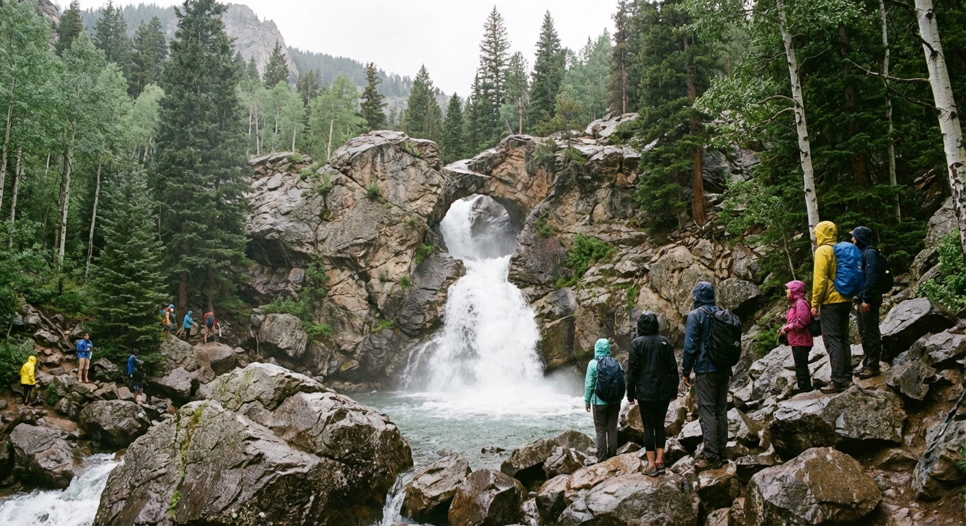
1) Donut Falls (Big Cottonwood)
- Distance: about 3.0 miles round trip (approx.)
- Elevation gain: about 450 feet (approx.)
- Shade: High, mostly forested
- Why go: A real waterfall that feels like a treasure hunt, with a unique “donut” rock opening where the water funnels through
- Parking: Popular. Arrive early on weekends and expect a full lot in peak summer
- Dogs: Generally not allowed in Big Cottonwood watershed areas. Confirm current rules on signage before you go
- Snow notes: One of the earlier canyon hikes people attempt, but icy sections are common in shoulder season
This is the classic “I want to see something cool without committing to a half-day suffer” Wasatch hike. The trail is friendly, but the final scramble near the falls can be slippery, especially when wet or icy. With little kids, consider stopping at the lower viewpoint rather than pushing into the slick rocks.
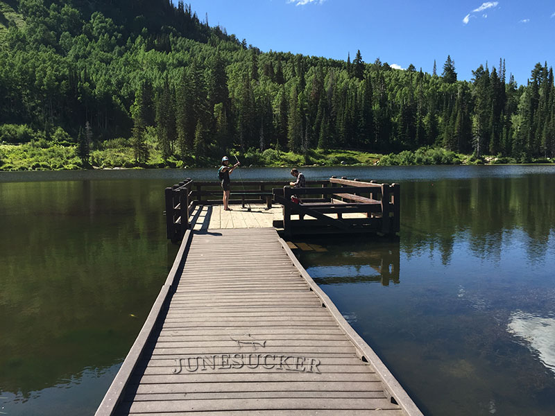
2) Silver Lake Loop (Brighton, Big Cottonwood)
- Distance: about 0.9 miles loop (approx.)
- Elevation gain: minimal
- Shade: Mixed, with trees around parts of the lake
- Why go: Boardwalk-style ease with big mountain vibes, great for families and sturdier strollers (think jogging stroller or larger wheels)
- Parking: Can fill on weekends and fall color days
- Dogs: Generally not allowed in Big Cottonwood watershed areas. Confirm current rules on signage before you go
- Snow notes: At higher elevation, snow can linger longer and arrive earlier than the valley
If you want maximum scenery for minimal effort, this is the one. It feels like a postcard version of the Wasatch, especially in early fall. Pair it with an easy picnic and you have an “outdoorsy” day that still leaves energy for a nice dinner back in town.
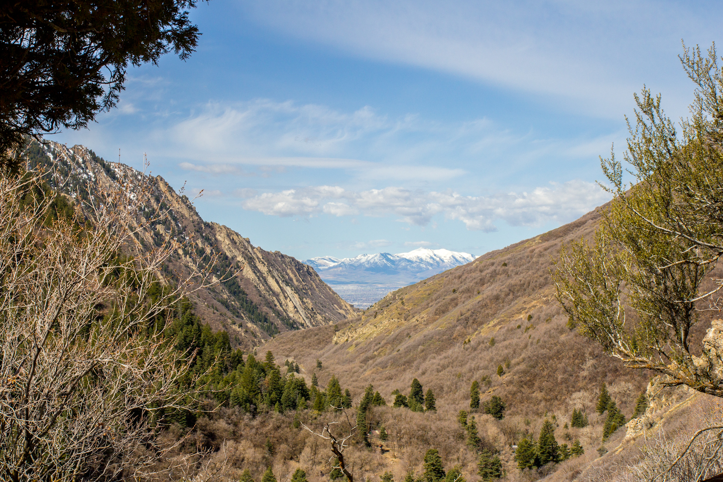
3) Rattlesnake Gulch to Pipeline (Millcreek)
- Distance: about 2.0 to 3.5 miles round trip (approx., choose your turnaround)
- Elevation gain: about 500 to 800 feet (approx., depends on route and turnaround)
- Shade: Low to moderate
- Why go: A steady climb with big valley views and the option to turn it into a gentler out-and-back on the Pipeline
- Parking: Moderate, can get busy on weekends
- Fee: Millcreek Canyon often has a vehicle fee (commonly around $5). Check current fee hours and payment details
- Snow notes: Exposed sections melt out faster, but shaded corners can hold ice
This is a great “starter climb” if you want to feel like you earned your view without going full summit mission. The Pipeline section is a nice confidence-builder because the grade relaxes and you can cruise.
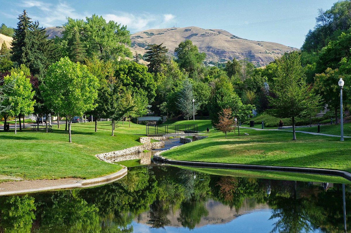
4) Memory Grove to City Creek (downtown)
- Distance: flexible, 1.5 to 4.0 miles round trip (approx.)
- Elevation gain: gentle to moderate, increases as you go deeper
- Shade: Moderate, with trees and canyon walls
- Why go: The easiest “from the city to the mountains” transition. Perfect if you do not want to drive a canyon
- Parking: Street and small lot parking, easier if you go early or use a rideshare
- Snow notes: Shaded paths can be icy in winter and early spring
This is my go-to when I am short on time or traveling without a car. You can make it a stroll, a jog, or a longer ramble. It is also ideal for visitors who want to see how quickly Salt Lake slips into canyon landscape.
5) Ensign Peak (sunset)
- Distance: about 1.0 mile round trip (approx.)
- Elevation gain: about 400 feet (approx.)
- Shade: Low, mostly exposed
- Why go: One of the best short-payoff viewpoints over downtown and the Great Salt Lake basin
- Parking: Small trailhead parking, fills around sunset
- Snow notes: Can be muddy after rain and icy in winter due to packed foot traffic
Ensign Peak is short, but it is not “flat.” The climb is quick and honest. If you are visiting for a weekend and want one iconic view without a big time investment, do this near golden hour. Bring a light layer because the breeze up top likes to humble you.
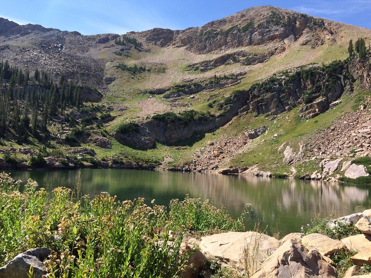
6) Cecret Lake (Alta, Little Cottonwood)
- Distance: about 1.8 miles round trip (approx.)
- Elevation gain: about 500 feet (approx.)
- Shade: Moderate
- Why go: A small alpine lake with a big “I cannot believe this is a day trip” feeling
- Parking: Seasonal access and parking can be tricky in peak periods
- Fee: In summer, expect a paid entry or parking fee for Albion Basin access. Check Alta’s current fee and booth hours
- Dogs: Generally not allowed in Little Cottonwood watershed areas. Confirm current rules on signage before you go
- Snow notes: Higher elevation. Snow can linger into early summer, and early fall storms can dust the trail
This is the “mini alpine” option. If you are visiting in the warm months and want a taste of the high Wasatch without committing to a long hike, Cecret Lake is a great pick. Check current access details before you go, since Alta is a ski area with seasonal logistics.
Pick the right hike
Best for kids or grandparents
- Silver Lake Loop for the easiest “mountain wow” factor
- Memory Grove to City Creek for low-commitment, no-canyon-drive vibes
One classic Wasatch pick
- Donut Falls is the crowd-pleaser for a reason
Quick workout and view
- Ensign Peak for sunset and city panoramas
Cooler temps mid-summer
- Higher canyon trails like Silver Lake Loop or Cecret Lake tend to feel more comfortable than exposed foothills
Accessibility and surfaces
If you want the lowest-fuss footing, here is the honest version:
- Most mobility-friendly: Silver Lake Loop (boardwalk and packed paths, some uneven sections) and Memory Grove (paved and hard-pack options near the park, rougher as you head deeper).
- More variable footing: Donut Falls and Cecret Lake have rocks, roots, and seasonal mud or snow, plus a short slick scramble at the falls that is not for everyone.
- Short but steep: Ensign Peak is quick, but the grade is direct and it can feel slippery when wet.
Urban comforts
My favorite kind of day is the one where you get trail dirt on your shoes and still end up somewhere with a real chair and excellent coffee. Plan your hike first, then give yourself a reward window back in the city so the day feels like a vacation, not an errand.
- Quick rinse plan: Keep a small towel and a change of shirt in the car. Your future self will thank you.
- Food timing: If you hike early, you beat both trail crowds and brunch lines. This is one of Salt Lake’s best life hacks.
- Leave no trace: Stay on trail, pack out snack wrappers, and keep noise down. These foothill and canyon systems get loved hard.
Safety notes
- Weather: Canyons can be cooler and windier than downtown. Check the forecast for the canyon area, not just the city.
- Water: Dry air dehydrates fast. Bring more than you think, especially for kids.
- Dogs and watershed rules: The Cottonwood Canyons are watershed areas with strict regulations and real fines. Rules can be nuanced and may change, so always read current canyon signage and check the official watershed info before you go.
- Wildlife: Give animals space. In warmer months, watch for rattlesnakes on sun-baked foothill trails.
- Trail etiquette: Uphill hikers generally have the right of way. Step aside on narrow sections and keep groups from blocking the whole path.
If you are visiting on a weekend and only have time for one hike, choose based on your real priorities: shade, views, or low logistics. Salt Lake makes it easy to do all three, but not always on the same trail.