Shiprock: Where to View It, Photograph It, and Respect It
Maya Lin
Maya Lin is a travel journalist and outdoor enthusiast who believes the best trips combine rugged adventures with urban comforts. After spending six years backpacking across four continents, she founded Trail & Town Guide to help fellow travelers navigate both hidden mountain passes and bustling city neighborhoods with confidence.
Shiprock is the kind of landmark that makes you want to pull over immediately the first time you see it. A dark volcanic monolith rising out of the high desert, it looks like a mountain that got stranded mid-migration. It is also a place where the usual Southwest travel instincts can lead you straight into disrespect or a ticket, especially if you treat it like a hike destination.
This page is for travelers who want the view, the photo, and the story without crossing lines. We will cover what is legal, what is customary on the Navajo Nation, the best light for photos, which highways give you the classic angles, and how to stack Shiprock into a Four Corners loop without turning it into an off-limits adventure.
Shiprock basics
Shiprock sits near the town of Shiprock in San Juan County, northwestern New Mexico, within the Navajo Nation. The formation is known in Diné (Navajo) tradition as Tsé Bitʼáʼí, often translated as “rock with wings.” It is widely regarded as sacred.
Two practical takeaways come from that:
- Do not plan to climb it. Shiprock is treated as closed to recreational climbing under Navajo Nation rules.
- Plan for roadside viewing. Most visitors should expect to photograph Shiprock from public paved roads and legal pullouts, not from the base.
Instead, Shiprock is best experienced as a roadside viewpoint or a short photo stop on a longer drive.
Official rules and permits
Rules on the Navajo Nation can change, and local signage always wins. Before you go, it is worth checking current policy for anything beyond simple roadside viewing.
- Navajo Nation Parks and Recreation: https://navajonationparks.org/
- Navajo Nation film and photography permits (including questions about drones and commercial work): https://navajofilmoffice.navajo-nsn.gov/
If you are hoping to do anything that sounds like “access,” “base of the rock,” “off the pavement,” “professional shoot,” or “drone,” assume you need explicit permission and possibly a permit. When in doubt, do less, not more.
One important nuance: policies often differ between personal and commercial filming, and restrictions can apply either way. If you want to fly a drone or shoot anything that could be interpreted as commercial or published work, verify requirements with the Film Office before you even unpack gear.
Can you climb or hike to it?
Climbing
Recreational climbing on Shiprock is prohibited without authorization under Navajo Nation rules. Many sources date the modern climbing closure to around 1970, following a fatal accident and subsequent policy changes, but the most practical takeaway for travelers is simple: treat Shiprock as closed to recreational climbing unless you have explicit, documented authorization from the Navajo Nation.
Walking to the base
There is no established public visitor trail system that works like a national park approach route. In some cases, any off-road access may be possible only with explicit permission and, depending on what you are doing, an authorized guide or permit. For most travelers, the respectful, low-risk plan is simple:
- View from public paved roads and legal pullouts.
- Do not cross fences, gates, cattle guards, or posted signs.
- Do not follow GPS onto dirt two-tracks. Google Maps and other apps can misroute visitors onto private Navajo dirt roads that look public until they are not.
- Be cautious with drones and aerial filming. Navajo Nation policy can require permits for filming and may restrict drone use. Verify current rules with the Navajo Nation Film Office before you fly.
If your plan requires you to step off the shoulder and into open desert “just for a better angle,” pause. Around Shiprock, that is often the moment you leave the public right-of-way and enter land you do not have permission to be on.
Where to get legal views
The good news: Shiprock is big enough to photograph beautifully from a distance. You do not need to get close to get a powerful frame.
Getting oriented
Most travelers reach the area via US 64 and US 491, often coming from Farmington to the southeast, Gallup to the south, or Shiprock town itself. Once you are on the main paved corridors, you can get excellent views without chasing back roads.
Best roads for views
For most travelers, the most reliable legal viewpoints come from these paved routes:
- US Highway 491: A primary north–south approach corridor with long, clean sightlines where Shiprock grows larger by the mile.
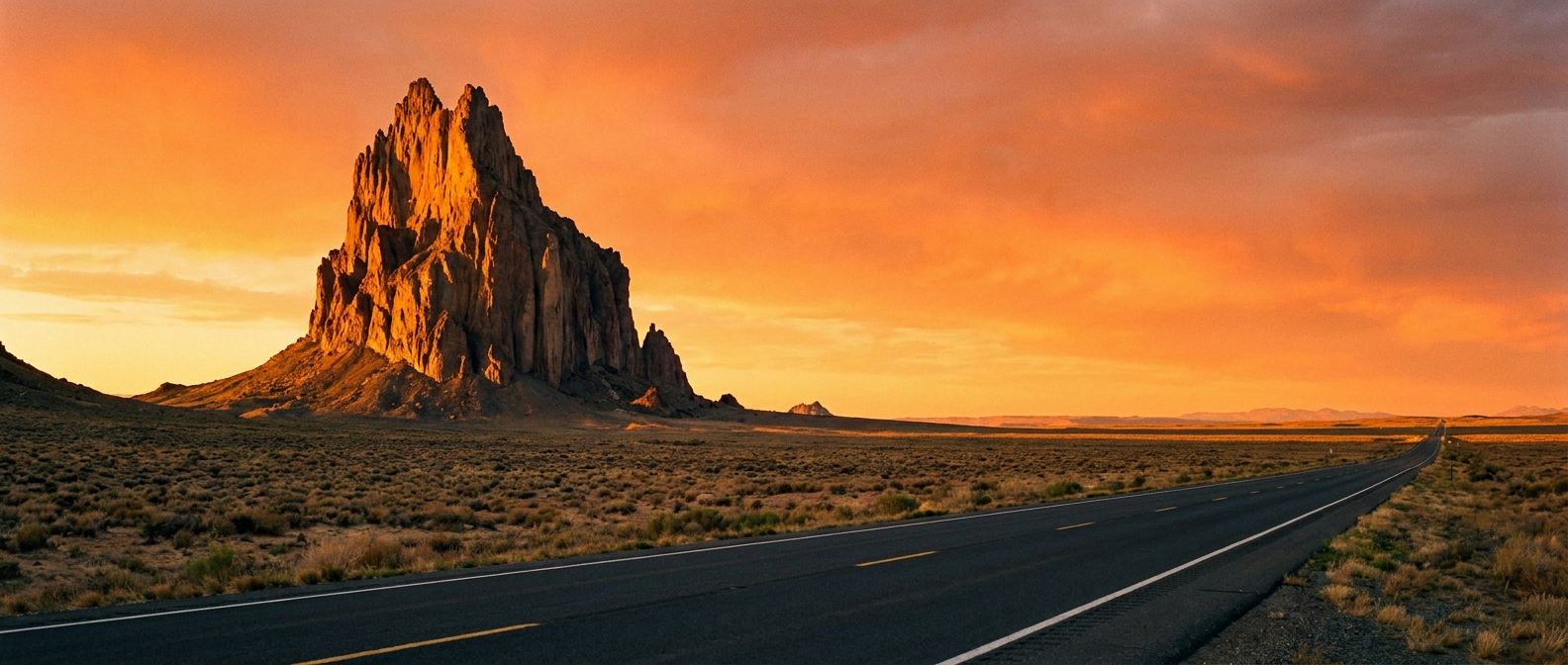
- Route 13: This is the corridor many photographers use for the classic “road leading to the rock” composition. Depending on where you are, signage and maps may show it as Navajo Route 13, Indian Route 13, or BIA-13. Treat it as the same general route, and rely on what you see on road signs in real time.
You can also see Shiprock from other regional roads as you move through the area, but if you stick to US 491 and Route 13 for your main photo passes, you will cover the most iconic angles without going hunting down random dirt lanes.
What “public right-of-way” means
Think of it like this: stay on pavement, maintained shoulders, and obvious pullouts where stopping is allowed and your vehicle is fully off the travel lane. Avoid walking beyond the graded roadside into open desert, and do not step onto two-tracks that are not clearly signed as public.
Safety note: Northern New Mexico and Navajo Nation roads can be fast, with trucks and crosswinds. Watch for free-range livestock. If you cannot pull completely off the roadway and open your door without stepping into traffic, keep driving. There will be another angle.
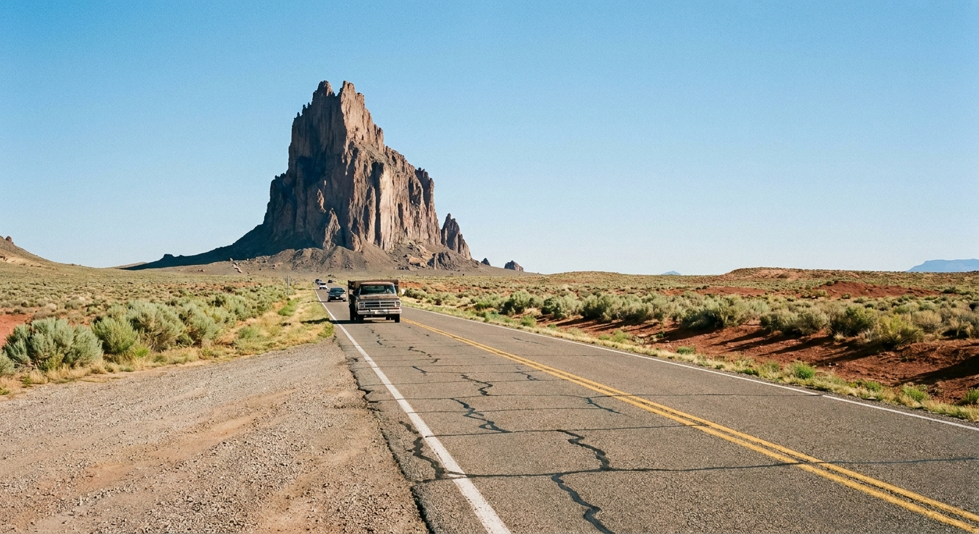
Photo etiquette
I grew up in Colorado where “public land” often means “point your camera anywhere.” The Navajo Nation is different, and that difference matters. A respectful Shiprock stop is less about getting the perfect shot and more about behaving like a guest.
Do this
- Keep your feet where you are clearly allowed to be. Paved pullouts, maintained shoulders, and places meant for stopping.
- Let local signage and local requests override any blog post. Etiquette around sacred sites can vary, and the closest community context matters most.
- Ask before photographing people, homes, or ceremonies. When in doubt, do not.
- Be discreet with long lenses. A faraway portrait of someone on their property can feel invasive even if you never cross a fence.
- Leave no trace at pullouts. Pack out everything, including coffee cups and orange peels.
Avoid this
- Do not treat Shiprock like a prop. No scrambling on nearby rocks, no “I climbed it” poses on private berms.
- Do not trespass for foreground elements. That perfect fence line or wildflower patch might sit on someone’s grazing land.
- Do not fly drones without verifying rules and permits. Aside from policy, it can be disruptive in a place many consider sacred.
If you want deeper cultural context, consider hiring a Navajo guide elsewhere on your Four Corners route (Monument Valley is the classic option) and bringing that same listening mindset to Shiprock.
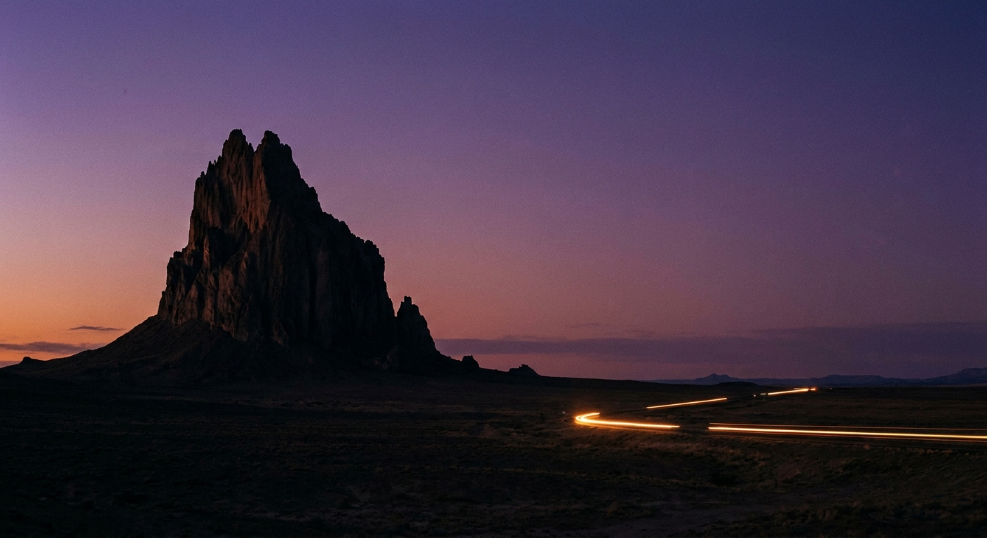
Best time for photos
Shiprock photographs well in almost any weather, but light and haze can make the difference between “iconic” and “flat.” Here is how I plan it.
Golden hour
- Morning: crisper air, less heat shimmer, and often clearer distance visibility.
- Evening: dramatic color, especially if there are high clouds catching sunset light.
Midday
Midday sun can be harsh, but it can also give you a graphic, high-contrast look that suits Shiprock’s volcanic edges. If you are shooting midday:
- Use a polarizer if you have one to deepen the sky.
- Embrace wide compositions with lots of negative space.
- Expect heat shimmer in summer, especially from low roadside angles.
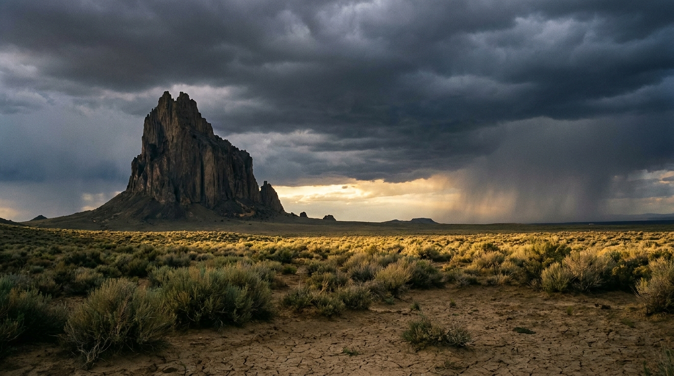
After storms
If you catch a clearing storm, you can get moody skies, rain curtains in the distance, and that freshly washed desert color. Pullouts can get muddy fast, so keep your tires on pavement or well-packed gravel.
Viewpoints without a hike
Because roadside conditions change and not every shoulder is safe to stop on, I recommend using this simple approach rather than chasing one exact “secret spot”:
1) The classic road shot
Your best odds for the “road leading to the rock” composition are along Route 13 (often labeled Navajo Route 13, Indian Route 13, or BIA-13 depending on signage and maps). Drive it like a scout mission. If you find a wide, legal place to pull fully off the road, take the shot. If you do not, keep moving. A good photo is never worth a dangerous stop.
2) The approach shot
On US Highway 491, Shiprock often sits out there like a fixed point on the horizon. Look for legal pullouts that let you place the monolith in a clean, simple frame with desert scale.
3) The distant telephoto
On clear days, Shiprock makes a great telephoto subject from farther away, especially if you can layer it with mesas or storm light. This is also one of the lowest-impact ways to photograph a sacred landmark. You are not pressing in for access.
How to add it to a loop
Shiprock is best treated like a scenic stop you build into a drive, not a standalone destination that needs half a day. Here are three easy ways to do it.
Option A: Monument Valley to Shiprock to Durango
- Best for: travelers heading toward Colorado
- Why it works: you trade one big-ticket landscape (Monument Valley) for another iconic silhouette with minimal detour
Plan Shiprock as a short stop on the way north or east. Keep it simple: pull over, shoot for 10 to 20 minutes, grab coffee or supplies in town if needed, then continue.
Option B: Four Corners to Shiprock to Goosenecks
- Best for: a full-day loop of landmarks and viewpoints
- Why it works: Shiprock gives you a dramatic mid-loop visual anchor without adding a hike
If you are already doing Four Corners and Goosenecks, Shiprock fits as a “look but do not linger too long” stop. Aim for golden hour if you can, since Goosenecks is also gorgeous at sunrise or sunset.
Option C: Farmington base, sunrise drive
- Best for: travelers who want comfort, coffee, and an early shoot
- Why it works: Farmington has more lodging and food, and Shiprock is an easy out-and-back drive
This is my favorite “rugged plus urban comforts” combo. You get a quick dawn mission and then a real breakfast afterward.
Planning tip: cell service can be inconsistent in pockets. Download offline maps before you leave your hotel, and do not count on last-minute route changes on the road. Also, be wary of navigation apps offering “shortcuts” onto unpaved routes. If the road suddenly turns into a dirt two-track, that is your cue to stop and reassess.
Know before you go
- Favor daylight driving. Livestock, limited shoulders, and fast traffic make night stops a bad idea.
- Services can be sparse. Outside Farmington and Shiprock town, do not assume fuel, food, or bathrooms will be available right when you want them.
- Shoulder safety matters. If you cannot get fully off the lane, skip the stop and try a different pullout.
- Respect boundaries. Fences, gates, and signs are not suggestions, and “it looks empty” is not permission.
What to bring
- A longer lens if you have it (even a phone with a 2x or 3x option helps): distance is part of respectful viewing here.
- Wind layer: the high desert can be deceptively chilly, especially at sunrise.
- Water: even for a “just photos” stop, you are in an arid climate.
- Trash bag: leave pullouts cleaner than you found them.
- Patience: if the shoulder is tight or traffic is fast, skip the stop and try again later.
Quick FAQ
Is Shiprock open to visitors?
You can generally view Shiprock from public roads. Access to the formation itself is not treated as an open recreational area.
Can I drive right up to Shiprock?
You can drive through the town area and see it closely from afar, but there is not a typical visitor “entrance” that takes you to the base like a national park viewpoint.
Is it worth stopping if I already did Monument Valley?
Yes, if you like photography and big geology. Monument Valley is all about many buttes and a self-drive culture. Shiprock is one singular, sacred silhouette that hits differently, especially in clean morning light.
Any final etiquette rule?
If you feel like you need to be unnoticed, that is a sign you do not have permission. Keep it simple, keep it legal, and let the view be enough.
A respectful way to remember it
Shiprock rewards the travelers who can appreciate a landmark without trying to conquer it. Treat it like a powerful roadside cathedral: you come close enough to feel the scale, you speak softly with your camera, and you leave with the memory intact for the next person rolling up the highway with the same wide-eyed look you had.