The Wave: Permits, Navigation, and Weather
Maya Lin
Maya Lin is a travel journalist and outdoor enthusiast who believes the best trips combine rugged adventures with urban comforts. After spending six years backpacking across four continents, she founded Trail & Town Guide to help fellow travelers navigate both hidden mountain passes and bustling city neighborhoods with confidence.
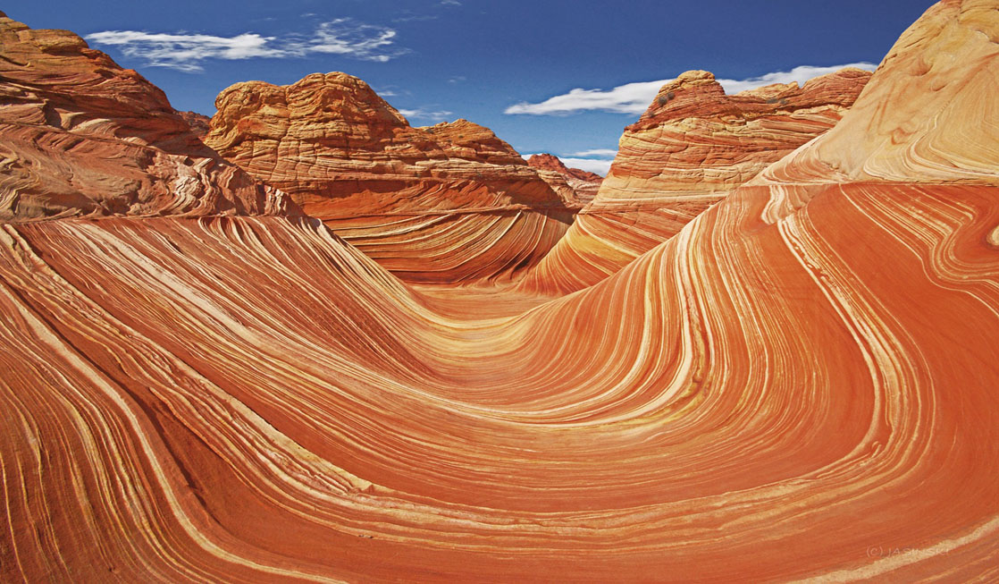
The Wave is one of those places that looks like it was dreamed up in a darkroom. But the experience is less about “show up and hike” and more about three things: getting a permit, staying oriented on a trail that is not really a trail, and timing your day around desert weather that does not negotiate.
This is Coyote Buttes North, managed by the Bureau of Land Management (BLM) on the Arizona-Utah border. The permit system is strict, the terrain is deceptively slick, and the conditions can swing from perfect to dangerous faster than your camera can focus. Below is the clear, practical breakdown I wish someone had handed me the first time I started chasing those famous sandstone lines.
At a glance
- Permit: Advanced online lottery plus a daily geofenced mobile lottery on Recreation.gov
- Hike: Moderate distance, serious route finding and exposure
- Road: House Rock Valley Road can be easy when dry and a trip-ender when wet
- Best seasons: Spring and fall for temps, winter and summer only if you respect the tradeoffs
What Coyote Buttes North is
Coyote Buttes North is the permit area. The Wave is the headline feature inside it. Your permit allows day hiking in Coyote Buttes North, which means you can visit the Wave and other formations in the same zone if conditions and time allow.
- Location: Near Page, Arizona, but the access roads and trailhead are closer to Kanab, Utah in feel and logistics.
- Access: No services at the trailhead. Cell service is often limited. Do not plan on “figuring it out when we get there.”
- Hike profile: Moderate mileage, but the difficulty is route finding, sun exposure, and footing on sandstone and sand.
Permit system
BLM limits Coyote Buttes North to a small number of hikers per day. That is why the photos look empty. It is also why permits are competitive.
Always confirm the latest rules on the official listing before you lock in travel plans. The current permit platform is typically Recreation.gov, and details can change.
Advanced online lottery (plan ahead)
The advanced lottery is for people planning in advance. You apply for a specific month and list a set of preferred dates. If you win, you reserve and pay for your permit through the official portal.
- Best for: Travelers with flexibility across multiple dates and the ability to apply months ahead.
- Reality check: Odds are typically low in peak seasons. If you only have one possible day, you are effectively buying a lottery ticket.
Daily lottery (near-term)
The old in-person, bingo-ball style walk-in lottery has been replaced by a daily geofenced mobile lottery run through Recreation.gov. Translation: you need to be physically in the area (inside the required geofence), and you enter using your phone rather than lining up at an office.
- Best for: People already in the region who can be flexible day to day.
- Tradeoff: You may spend valuable travel time trying without success, and you are still subject to weather and road conditions even if you win.
Town Wander tip: If The Wave is your top priority, give yourself a multi-day buffer in the Kanab-Page area. You will enjoy the region more when your schedule is not hanging on a single draw.
Lottery odds
Most people ask, “What are my odds?” The more useful question is, “How many tries can I realistically afford?”
What affects your chances
- Season: Spring and fall are the most competitive because temperatures are friendlier and road conditions are often better.
- Group size: Smaller groups can be easier to fit into the daily quota. (Also note that max group size rules exist, and they can change, so verify on the official portal.)
- Date flexibility: The more dates you can accept, the better.
- Willingness to go off-peak: Summer heat and winter storms deter many people, but they also come with genuine safety tradeoffs.
A practical strategy
- Apply broadly: If you are using the advanced lottery, choose as many acceptable dates as the system allows.
- Keep your group lean: If you are traveling with friends, consider splitting into smaller groups only if everyone is comfortable hiking and navigating independently. Do not do this just for odds.
- Build a Plan B itinerary you actually want: If you lose, you should still have a great trip, not a consolation prize.
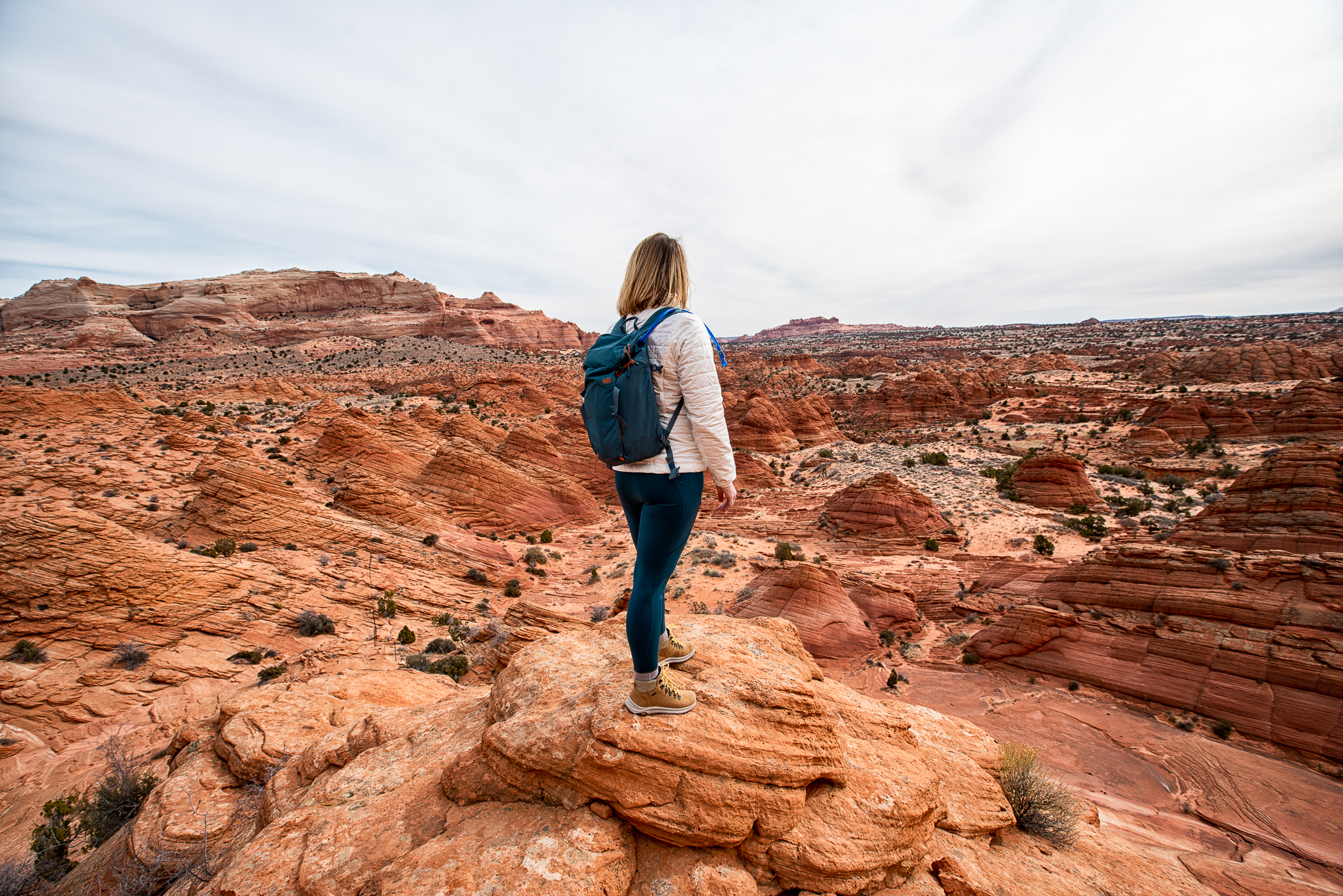
Route finding
People get turned around at Coyote Buttes North because they expect a maintained trail. Instead, you will encounter a mix of sand, slickrock, and subtle terrain cues. The route is more “follow the landscape” than “follow the tread,” with stretches that can feel like linking open slickrock benches between sandy washes.
Baseline expectations: Plan on roughly a half-day outing for most hikers, and know that route finding and exploring can add time and mileage. The exact distance depends on the line you take, what you visit beyond the Wave, and how many “is this it?” detours you accidentally earn.
Common navigation pitfalls
- Over-trusting footprints: Tracks wander. People explore. Wind erases. Do not follow prints blindly.
- Over-trusting cairns: Cairns can multiply, drift, or be built by well-meaning people who are also lost. Do not rely on them. Also, do not build new cairns. It is not helpful out here.
- Waypoint obsession without context: A GPS dot helps, but it will not warn you about cliffs, pour-offs, or closures.
- Route drift on slickrock: On sandstone, you can walk beautifully in the wrong direction.
- Late starts: Navigation mistakes feel small at 9 a.m. and become serious when you are racing sunset or thunderstorms.
How to stay found
- Carry the official permit map information: Your permit packet typically includes route guidance. Read it before you hike, not at the trailhead.
- Use offline navigation: Download maps for offline use. Bring a power bank. Assume no service.
- Know your turnaround time: Set a firm time to head back, even if you have not reached the Wave yet.
- Keep your group together: The fastest way to turn a minor wrong turn into a rescue scenario is splitting up.
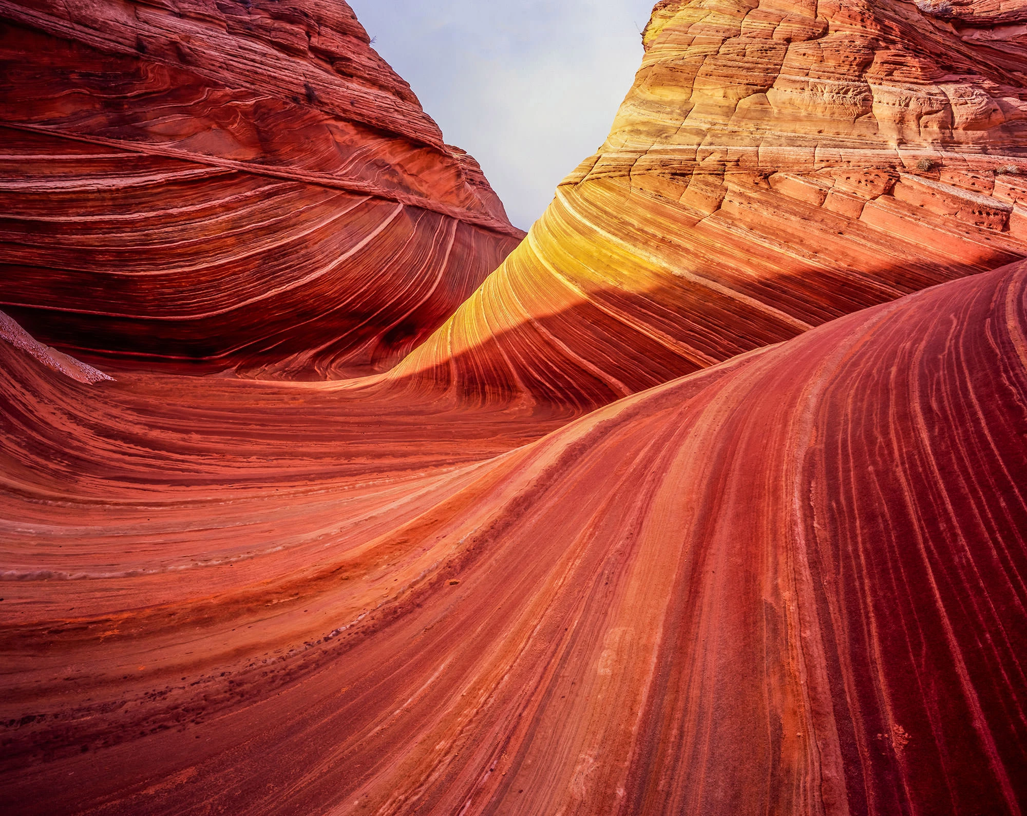
Sandstone safety
The Wave’s sandstone looks soft in photos. Underfoot it can be grippy, polished, sandy, or surprisingly slick depending on conditions.
Footing basics
- Wet sandstone is slick: After rain or during freezing conditions, traction drops dramatically.
- Sand on slickrock acts like ball bearings: Step deliberately, especially on angled slabs.
- Edges and ledges are real: The area includes drop-offs. Do not free-scramble where a slip has consequences.
What to wear and bring
- Footwear: Trail shoes or boots with solid tread. Avoid worn soles.
- Trekking poles: Helpful in sand and on uneven slickrock, especially for the return when legs are tired.
- First aid: Scrapes happen. So do ankle tweaks. Be prepared to self-manage small injuries.
Weather windows
In the desert, “nice weather” is not a vibe. It is a safety plan. Coyote Buttes North is not a slot canyon, but storms still matter here because slickrock gets treacherous fast and the access roads can turn into impassable clay.
Best seasons for most hikers
- Spring and fall: Typically the most comfortable temperatures, but also the most popular and not immune to storms.
- Winter: Fewer people, crisp light, but cold, snow, and ice can make both roads and slickrock hazardous.
- Summer: Extreme heat is the main risk. Monsoon storms can also appear, bringing lightning and sudden downpours.
What to watch in forecasts
- Heat: High temperatures combined with full sun exposure can turn a moderate hike into a medical emergency.
- Wind: Sandblasting wind is not just annoying. It increases dehydration and makes navigation harder.
- Thunderstorms: Lightning on exposed slickrock is no joke. Also note that heavy rain can turn access roads into impassable mud.
Rule I live by out here: If storms are likely and you are not confident in the road conditions and your route, postpone. The Wave will still be there. Your margin for error might not be.
Heat strategy
There is very little shade on the route. In warm months, heat management is the trip.
Timing
- Start early: Aim to be hiking at first light when possible.
- Plan for a slower pace: Heat adds fatigue. Build extra time for breaks and navigation checks.
Water and electrolytes
- Carry more than you think: Desert air dries you out fast. Many hikers underestimate water needs because the hike is not steep.
- Actionable baseline: In mild weather, many hikers are comfortable starting with at least 2 to 3 liters per person. In hot weather, that can jump to 3 to 5 liters or more depending on pace, body, and conditions. If you are unsure, carry extra.
- Add electrolytes: Plain water is not enough when you are sweating heavily.
- Know dehydration signs: Headache, chills, nausea, and confusion are red flags, not “push through” moments.
Sun protection
- Clothing: Lightweight long sleeves, sun hoodie, or breathable layers beat a tank top in this kind of exposure.
- Hat and sunglasses: The reflected light off sandstone is intense.
- Sunscreen: Reapply. The desert does not care that you put it on at the car.
Road access
Many Wave plans fail before the hike starts because of road conditions. The most common approach is via House Rock Valley Road. It can be straightforward when dry and a tire-slick, vehicle-trapping mess after rain. Conditions can change overnight.
- Check current conditions: Ask locally and confirm with BLM resources when available.
- Do not gamble with mud: Desert clay can become impassable even for capable vehicles.
- High clearance helps, until it does not: When the road is dry, some passenger cars make it. When it is wet, 4WD does not guarantee anything. Plan based on conditions, not optimism.
- Carry basics: Full-size spare, tire repair kit, shovel, extra water, and a way to communicate if you break down.
If you are not comfortable assessing remote road conditions, consider building your trip around seasons with more predictable access, or focus on nearby hikes that do not require committing to potentially impassable roads.
Photography ethics
It is tempting to treat The Wave like a studio set. It is not. It is a fragile landscape under heavy demand, and your choices matter.
Stay on durable surfaces
- Walk on slickrock when possible: Cryptobiotic soil and desert crusts are alive and extremely slow to recover once crushed.
- Avoid widening social routes: If you need to step off a line, choose the most durable option and step lightly.
Respect other people’s experience
- Take turns: The classic Wave angles are limited. A few minutes is reasonable. A long photo shoot can dominate the space.
- Be mindful with drones: Rules vary and can change. Confirm legality and restrictions before you even pack one.
Leave no trace
- No sand smoothing: Do not sweep footprints for the perfect shot.
- No chalk, no props: Keep the scene natural. The best desert photos look like nobody staged them.
- No DIY cairns: Building cairns contributes to route confusion and visual clutter.
If you do not win
If you are reading this, you probably want the Wave specifically. That is fair. It is iconic for a reason. But if the lottery does not go your way, you can still have an unforgettable sandstone day near Page and Kanab without trying to “sneak a substitute.”
Near Page
- Wire Pass and Buckskin Gulch (access dependent): A slot canyon experience with serious flash flood considerations. Only go with solid weather awareness.
- Horseshoe Bend area walks: Short, accessible viewpoints with big payoff, best at sunrise or late afternoon.
- Glen Canyon National Recreation Area trails: A mix of desert overlooks and water-adjacent scenery that pairs nicely with a town day in Page.
Near Kanab
- Sandstone hikes and overlooks: The Kanab area is packed with photogenic terrain where permits are not as intense, though some areas still require reservations or have capacity limits.
Important: Do not treat “nearby” as “the same.” Many Wave look-alikes are in separate permit zones or on protected land with their own rules. Always confirm land management and access requirements before you go.
Quick checklist
- Permit and ID: Have them accessible, not buried in a pack.
- Offline maps: Downloaded and tested before you leave town.
- Water plus electrolytes: Carry extra, not exact.
- Sun system: Hat, sleeves, sunscreen, sunglasses.
- Traction-minded footwear: Good tread, secure fit.
- Weather checked twice: The night before and the morning of.
- Road plan: Know what you will do if House Rock Valley Road looks worse than expected.
- Turnaround time: Decide it early, respect it later.
One last thing
This is where my “rugged adventure, urban comforts” bias shows. If you are basing in Page or Kanab, use the town time wisely. Eat a real meal the night before. Get coffee and extra water in the morning. Ask a local shop about road conditions. Then go hike like you mean it.
The Wave rewards preparation more than bravado. Win the permit, pick the right weather window, navigate with intention, and you will earn every one of those swirling lines on your camera roll.