Tonto Natural Bridge State Park: Waterfall Trails and Easy Loops
Tonto Natural Bridge State Park is one of those Arizona surprises that feels like it belongs in a rainier state: a travertine arch spanning a creek, a shaded grotto, and seasonal water trickling or roaring depending on recent storms and snowmelt. It is also refreshingly doable. You can get big scenery without committing to a huge mileage day, which makes it a favorite for families, first-time hikers, and anyone who wants a trail moment before returning to a real bed and a great coffee in Payson.
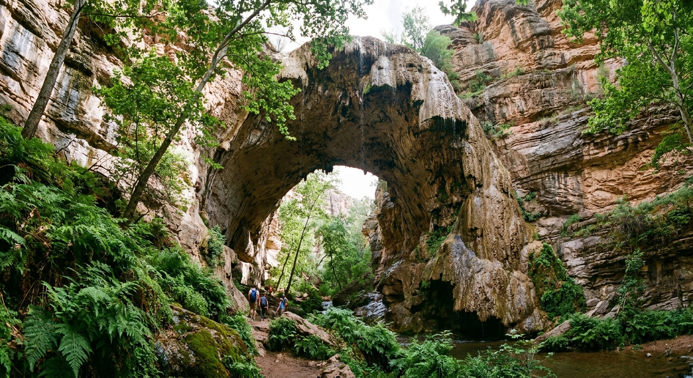
One more reason it earns its hype: it is widely believed to be the largest natural travertine bridge in the world. In person, that scale hits differently.
This guide breaks down the main trail choices (by name) to see the bridge from above and below, how to plan around water levels and slippery rock, and how to stitch the park into an easy day with Payson or Roosevelt Lake.

Quick facts for planning
- Location: Near Payson, Arizona, in the Pine Creek area.
- Vibe: Short but steep trails into a shaded canyon, with a dramatic natural bridge and seasonal waterfall flow.
- Best for: Families with older kids, casual hikers who want a big payoff, photographers, and anyone seeking a cooler-feeling microclimate on hot days.
- Main decision: Do you want easy viewpoints from the rim, a steep hike to the base, or a loop that does both?
Fees and hours: Expect an entrance fee per vehicle, with day-use hours that can vary by season. Check the official Arizona State Parks site the morning you go for current pricing, closures, and any trail advisories after storms.
Bridge views from above
If you are traveling with little kids, grandparents, or anyone who would rather not tackle steep downhill and uphill, start with the rim viewpoints. These give you that jaw-drop moment without committing to the canyon hike.
Good option: Rim viewpoints
From the top area, you can walk to overlooks that peer down into the canyon and across to the bridge. The walking is generally short and manageable, and it is the best choice if the trails are wet or you are arriving in peak heat.
- Pros: Minimal effort, great for quick visits, good first stop to decide if you want to hike down.
- Cons: You do not get the full scale you feel from below, and photos can be trickier in contrasty light.
Bridge views from below
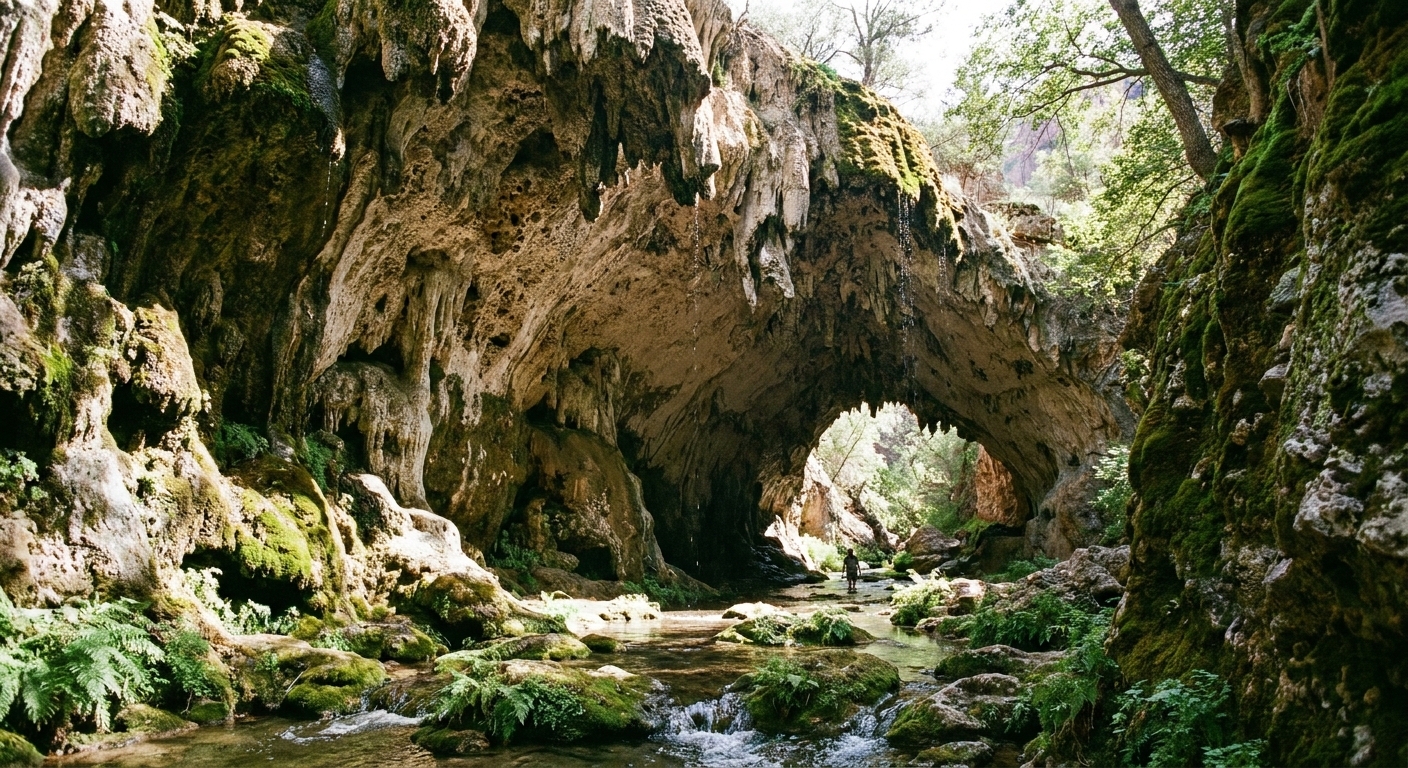
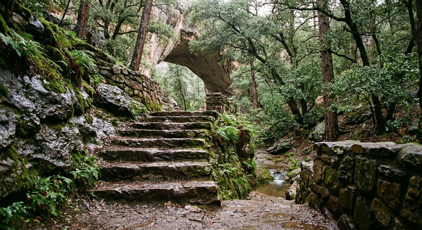
To really understand why this place is famous, hike down into the canyon. Below the bridge, you are surrounded by cool rock, dripping mineral textures, and the echo of water when it is running. It is not a long hike, but it can feel spicy because the grade is steep and the footing can be slick.
Trail options to get down
The park has several named trails that connect the rim to the creek area. In general, Gowan Trail and Anna Mae Trail are the classic steep-down, steep-up experience. Pine Creek Trail is often used as the more gradual-feeling route. The Waterfall Trail is a short connector near the bottom that helps you reach waterfall and under-bridge viewpoints when water is running.
- Short distance, steep grade: The descent goes fast. The climb back out is what you will remember.
- Footing: Expect uneven rock, steps, and sections where water or damp shade can make surfaces slippery.
- Payoff: Standing under the bridge is a true cathedral-of-stone moment, especially when water is flowing.
Trail reality check: if anyone in your group struggles with steep climbs, plan extra time for the return. The hike out can feel hotter and harder than the numbers suggest.
Best family-friendly loops
For many visitors, the sweet spot is combining rim views with a canyon hike, so you get the bridge from multiple angles without repeating too much trail.
Loop strategy that works
- Start early at the rim: Grab the overlook views while the light is softer and the temperature is lower.
- Descend on the more gradual-feeling route: If you want to ease into the canyon, consider using Pine Creek Trail for the descent, especially for mixed groups.
- Return via a different trail: Many visitors go down one of the steep classics like Gowan Trail or Anna Mae Trail and come back a different way for variety and morale.
- Use the Waterfall Trail near the bottom: When conditions allow, the Waterfall Trail can help you connect viewpoints and chase the sound of running water.
If you are hiking with kids, I like a simple rule: go down only as far as everyone can comfortably climb back up. The park is not the place to discover that the fun part was the descent.
Seasonal water and slip risk
Water at Tonto Natural Bridge is highly seasonal. Some days you will hear it before you see it. Other days, the creek is quieter and the falls are reduced to a trickle.
When you are most likely to see flow
- Late winter through spring: Often the best chance for steady flow thanks to snowmelt and seasonal precipitation.
- After monsoon storms (summer): Short-term boosts in water are possible, but trail conditions can change quickly.
- Dry stretches: In hot, dry periods the falls can be minimal. The bridge is still impressive, but the vibe is less waterfall oasis.
Slip risk is real here
The combination of shade, damp rock, and polished stone steps means you should treat this park like a hands-free zone. Secure your phone and keep your hands available for balance.
- Wear shoes with grip: Smooth-soled sneakers can feel sketchy.
- Slow down in shade: Moisture lingers where the sun does not hit.
- Skip risky scrambling: If a spot looks like a slide, it probably is.
Summer heat
Even though the canyon can feel cooler than the rim, summer in central Arizona is still summer. Plan for heat, especially on the climb back up when shade disappears and your heart rate spikes.
My hot weather plan
- Arrive early: Morning is calmer, cooler, and better for photos.
- Bring more water than you think: Short hikes still dehydrate you fast in dry air.
- Take breaks in shade: Use the canyon’s cooler pockets to reset.
- Sun protection matters: Hat, sunscreen, and sunglasses help on exposed sections near the top.
If the forecast is extreme, do the overlooks only and save the canyon hike for another day. You will still leave with a memorable view and a safer trip.
Rules to know
This park is very family-friendly, but a couple of rules surprise people, especially on a first visit.
- Pets: Dogs and other pets are not allowed on the trails. They are typically restricted to paved areas like the parking lots and rim-side viewpoints. If you are traveling with a dog, plan on enjoying the overlooks only or swapping turns.
- No swimming or wading: Swimming and wading in the creek under the bridge is strictly prohibited. Even when it looks calm, treat it as a look-only zone.
Accessibility and comfort
This is a great park for mixed groups, as long as everyone agrees on what hike means today.
- Best for strollers: Rim-area strolling and viewpoints are your friend. Canyon trails are not stroller-friendly.
- For toddlers: Consider a child carrier if you plan to descend.
- For anyone with knee concerns: Trekking poles can help on the descent and the climb out.
- Restrooms and picnic vibes: Plan a snack or picnic at the top before or after your hike so you are not hangry on steep trail.
Simple add-ons
Tonto Natural Bridge is easy to pair with a town meal or a lakeside cruise, which is exactly my kind of Arizona day: trail first, comfort second.
Combo A: Bridge + Payson
Hike in the morning, then head into Payson for a relaxed lunch and a coffee stop. Payson is one of those practical mountain towns where you can restock snacks, grab something cold to drink, and still feel close to the pines.
- Best for: Families, day-trippers, and anyone keeping the schedule light.
- Why it works: You get shade and scenery, then recover in town without rushing.
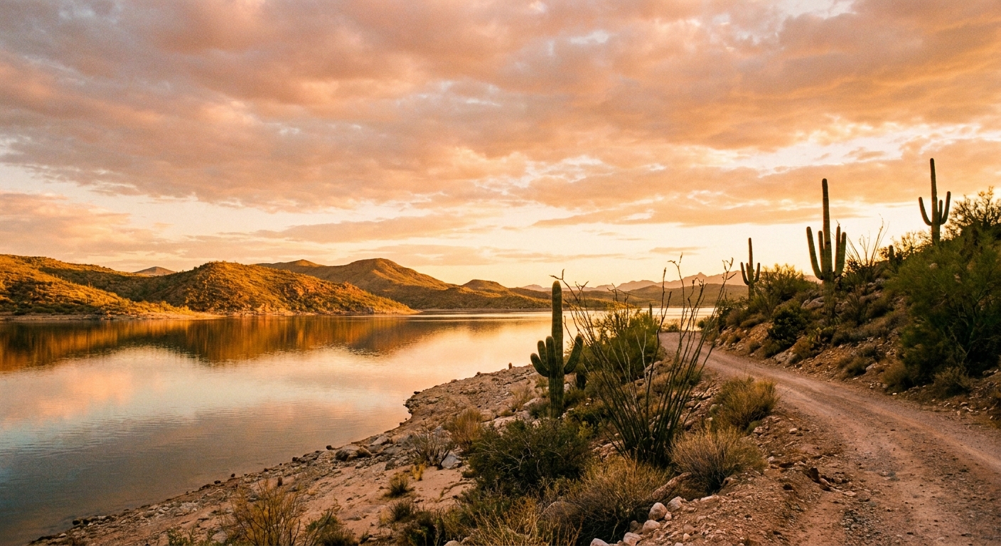
Combo B: Bridge + Roosevelt Lake
If you want water after your waterfall, point your day toward Roosevelt Lake for a change of scenery. The lake adds wide-open desert vistas that contrast beautifully with the park’s enclosed canyon.
- Best for: Travelers who want a full-day loop with variety.
- Tip: Pack extra water and snacks. Services can be more spread out once you leave town.
Packing list
You do not need much, but the right basics make the steep sections feel far less dramatic.
- Grippy hiking shoes or trail runners
- 1 to 2 liters of water per person depending on heat and your plans
- Salty snack plus a quick sugar snack for the climb out
- Hat, sunscreen, and sunglasses
- Light layer in cooler months, the canyon can feel chilly in shade
- Small first-aid basics, especially for scrapes
- Phone on a strap or zipped pocket for slippery sections
Leave no trace
This park’s magic is fragile: wet rock, living moss, and sensitive creekside habitat. Stay on established trails, do not shortcut switchbacks, and resist the urge to climb on slick or delicate surfaces. Pack out everything, including fruit peels and snack crumbs. If you want fewer crowds, aim for weekdays and shoulder seasons, and keep your group’s sound level low in the canyon where noise carries.
Suggested itineraries
60 to 90 minutes
- Arrive, pay entry, and start with rim viewpoints
- Walk the short paths near the top
- Picnic snack, then head to Payson
2 to 3 hours
- Rim viewpoints first
- Descend via Pine Creek Trail or one of the steeper options (Gowan Trail or Anna Mae Trail)
- Use the Waterfall Trail near the bottom if it is open and conditions are safe
- Take your time in the grotto area, then climb out slowly
- Late lunch in Payson or drive on toward Roosevelt Lake
If you only do one thing, do this: get both perspectives. The rim gives you the overview. The canyon gives you the scale and the chill-in-the-air feeling that makes this park so unexpectedly lush for Arizona.