Zion Observation Point Trail: Access, Closures, and Safer Options
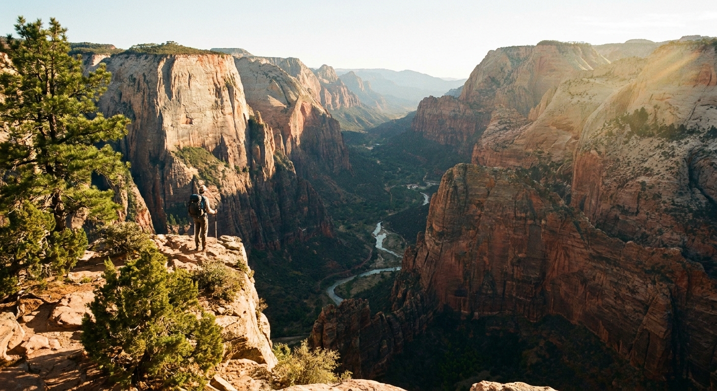
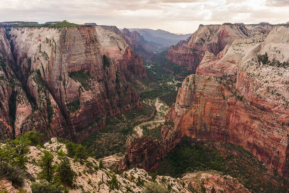
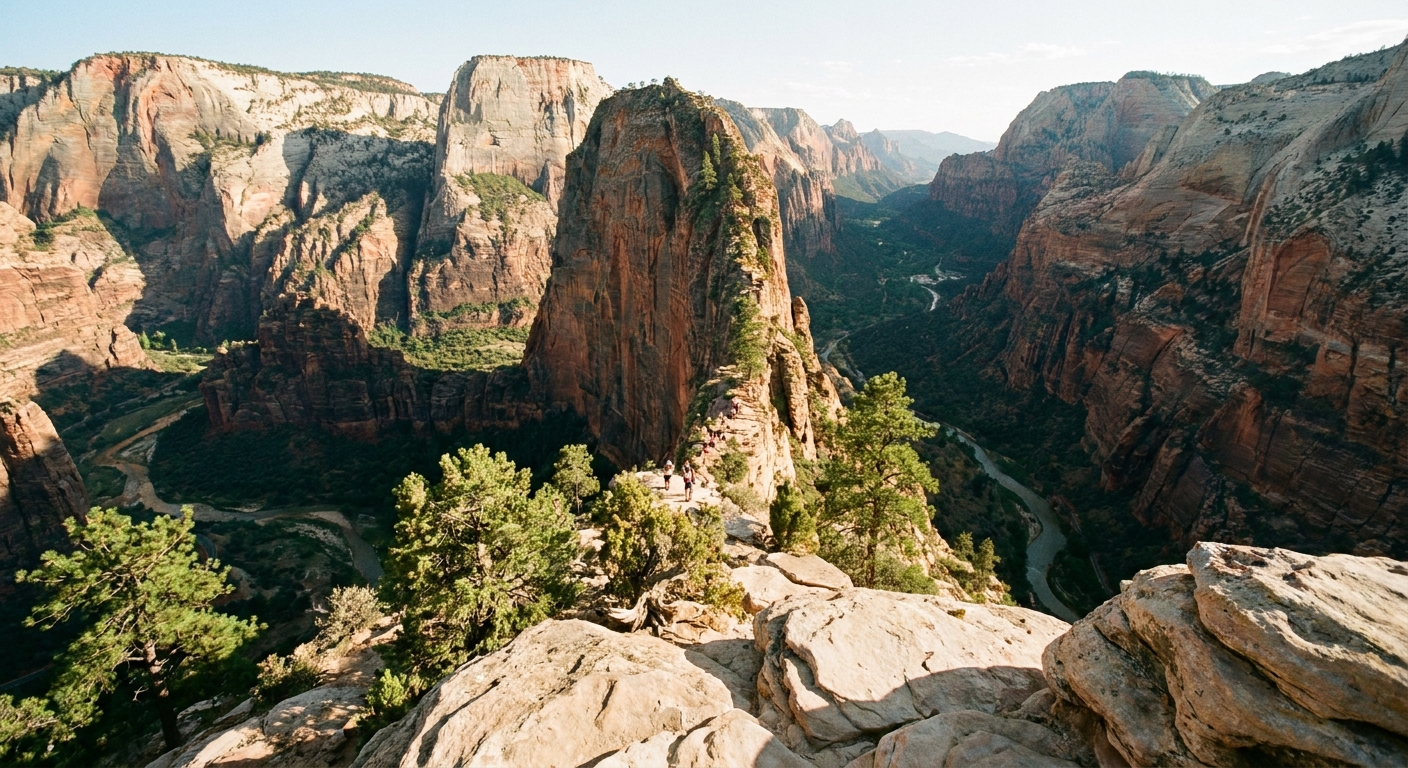
Observation Point is one of Zion’s classic big view hikes. It looks straight down into the main canyon with Angels Landing sitting like a little fin far below. The catch is that access has changed in recent years, and the route you remember might not be the route you can legally or safely hike today.
Below is the current, practical way to think about Observation Point: what is actually open, what tends to close seasonally, where ice and exposure become real problems, and which alternatives deliver similar wow factor with less stress.

What changed
Historically, many hikers reached Observation Point from the main canyon via Weeping Rock, using the Observation Point spur connected to the East Rim Trail. That area and its connecting segments have been closed for extended periods due to rockfall risk and ongoing management.
For planning purposes, keep it simple: do not assume you can hike to Observation Point from the Zion Canyon shuttle stops . Always confirm current status on the NPS current conditions page, because openings and closures can change with rockfall, repairs, and seasonal hazards.
When Observation Point is hikeable right now, many visitors reach it from Zion’s east side instead, most commonly via the East Mesa route or the Stave Spring route (both outside the main canyon).
Key takeaway
- Main canyon access is not the default anymore. Verify the exact trail segments that are open before you build your day around them.
- East side approaches are often the practical option. They are not on the Zion Canyon shuttle corridor, so logistics are different.
Slow travel tip: build your itinerary with flexibility. If Observation Point access changes last minute, you still have world-class hikes on both the east side and in Zion Canyon that do not rely on the same trail segments.
Observation Point via East Mesa
If you want the Observation Point view without white knuckle exposure, the East Mesa approach is usually what people mean when they say “Observation Point hike” these days.
Distance and terrain
- Typical distance: about 6.5 to 7.5 miles round trip, depending on the exact trailhead, drop-off, and any road gates.
- Elevation change: generally moderate, often around 600 to 900 feet total gain, and it varies based on where you start.
- Trail character: mostly sandy, forested mesa walking that opens to canyon views near the end.
- Exposure: low on the approach, high at the viewpoint itself. The overlook is a cliff edge environment even though the hike in feels mellow.
Access and road reality
East Mesa trailheads are reached via dirt roads that can become rough, rutted, or muddy after storms. Parking can also be limited, and cell service can be unreliable out there.
The most popular workaround is the Zion Ponderosa Ranch Resort shuttle, which helps solve the two big headaches in one move: trailhead parking and sketchy road conditions. You do not need a permit for the hike itself like Angels Landing, but you may be dealing with paid shuttles or private logistics to reach the start point.
Plan like you are going somewhere remote: no reliable water, no guaranteed toilets, and no guarantee your phone will save you if you get turned around .
Stave Spring route
Stave Spring is the other common east side way to reach Observation Point. It is often linked with the East Rim Trail system and typically feels more like a traditional backcountry hike than East Mesa.
How it compares
- Effort: usually more elevation change and a longer day than East Mesa, depending on where you start and which junctions are open.
- Vibe: fewer people, more “in the woods for a while” before the view payoff.
- Logistics: similar dirt road considerations apply, plus navigation matters more. Bring an offline map and do not count on cell signal.
Point-to-point option: Some hikers combine East Mesa and Stave Spring as a point-to-point route. It can be a fantastic way to avoid backtracking, but only if you have solid shuttle planning, clear trail status, and a map you trust.
Seasonal risks
Zion is a four-season park, and Observation Point planning changes dramatically once winter settles in .
Winter and ice
Even on the easier East Mesa approach, you can encounter:
- Hard-packed snow and ice in shaded forest sections
- Early morning freeze followed by afternoon melt that turns trails slick and muddy
- Wind at the rim that makes the overlook feel much colder than the hike in
If the trail is icy, traction devices can help on flat terrain. Still, the biggest risk is not the stroll through the trees. It is slipping near the rim or being pushed by wind when you are close to the edge. If you cannot confidently control your footing, treat the viewpoint like a “look from farther back” zone.
Monsoon season and storms
East side trails can get messy after heavy rain, and access roads can become impassable fast. In summer, start early, carry more water than you think you need, and watch the sky. The big issues to take seriously are muddy roads, slick trail sections, and lightning risk once you are on exposed rims or open slickrock.
My rule for Zion viewpoints: if you would not feel comfortable setting your phone down on a rock without it sliding, you are too close to the edge to be taking photos.
How it compares
These three Zion icons get lumped together, but they demand different skills and risk tolerance.
Observation Point
- Primary challenge: access logistics and conditions, plus cliff edge awareness at the overlook
- Typical experience: a longer, steadier hike with huge payoff views
- Permits: not the same permit system as Angels Landing, but always verify current rules, trail status, and any shuttle or access requirements
Angels Landing
- Primary challenge: sustained exposure and crowd management on chains
- Typical experience: shorter mileage, big elevation gain, and a narrow fin with drop-offs
- Permits: requires a permit for the chain section
The Narrows
- Primary challenge: water conditions, flash flood risk, cold exposure, and uneven riverbed walking
- Typical experience: hiking in a river between soaring walls
- Permits: day hikes from the bottom up generally do not require a permit, but top-down routes do
If you are deciding between them, Observation Point is often the best fit for hikers who want a marquee view but do not want the sustained exposure of Angels Landing or the water logistics of the Narrows .
Backup hikes
If Observation Point is closed, the road is a mess, or winter ice has you second guessing, you can still get that “Zion is unreal” feeling without forcing the plan.
Canyon Overlook
- Why it works: short hike, big views, easy to fit into a day with other stops
- Watch for: crowds and limited parking near the tunnel
Scout Lookout
- Why it works: you get classic canyon views and the sense of height without committing to the chains
- Watch for: heat and uphill effort, and be respectful of permit boundaries
Pa’rus at golden hour
- Why it works: low commitment, accessible, and surprisingly beautiful light bouncing off canyon walls
- Watch for: bikes and shared use traffic
Kolob Canyons
- Why it works: fewer crowds and dramatic scenery, especially if Zion Canyon feels packed
- Watch for: longer drive time depending on where you are staying
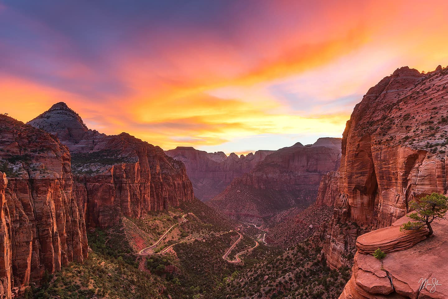
Photo tips
You do not need risky poses to capture Observation Point. The drama is already built into the landscape.
Better shots, safer habits
- Shoot with a wider lens, not a closer step. Back up from the rim and let the canyon do the work.
- Use people for scale from a safe distance. A small figure well away from the edge communicates height without the danger.
- Try morning for cleaner light. Midday can flatten the canyon. Early and late light brings out texture in the sandstone.
- Watch wind gusts. If you feel it tugging at your pack, stay farther back and keep both feet planted.
- Stay on durable surfaces. Do not trample fragile soils or cryptobiotic crust near rim areas and along the mesa.
My favorite “no drama” frame
Stand well back and frame Angels Landing in the lower third of your shot with the canyon walls rising behind it. It creates that jaw-dropping perspective without requiring you to be anywhere near a sketchy edge.
Before you go
- NPS current conditions: check the day before and the morning of your hike for trail closures and weather alerts.
- Route status: confirm your exact route is legal and open. Do not rely on old blog posts or outdated maps.
- Road status: if you are driving east side dirt roads, assume they can turn ugly after storms.
- Shuttle option: if parking or mud is a concern, look at the Zion Ponderosa Ranch Resort shuttle.
- Basic kit: water, sun protection, layers or a wind shell, headlamp, and an offline map or GPS.
- Rim respect: the view is worth it, and so is getting home safe.
Where to stay
If you love the “rugged day, cozy night” combo, Zion makes it easy.
- Springdale: walkable, close to shuttle access, lots of post hike food options and coffee stops.
- East side (near Zion-Mount Carmel Highway): quieter mornings and quicker access to east side trailheads, but fewer restaurants.
- St. George: more urban comforts and often better prices, but a longer drive to trailheads.
However you plan it, Observation Point is still one of Zion’s best payoffs. The trick right now is not toughness. It is choosing the right access, respecting closures, and matching the hike to the season.