Best Hikes in Saguaro National Park
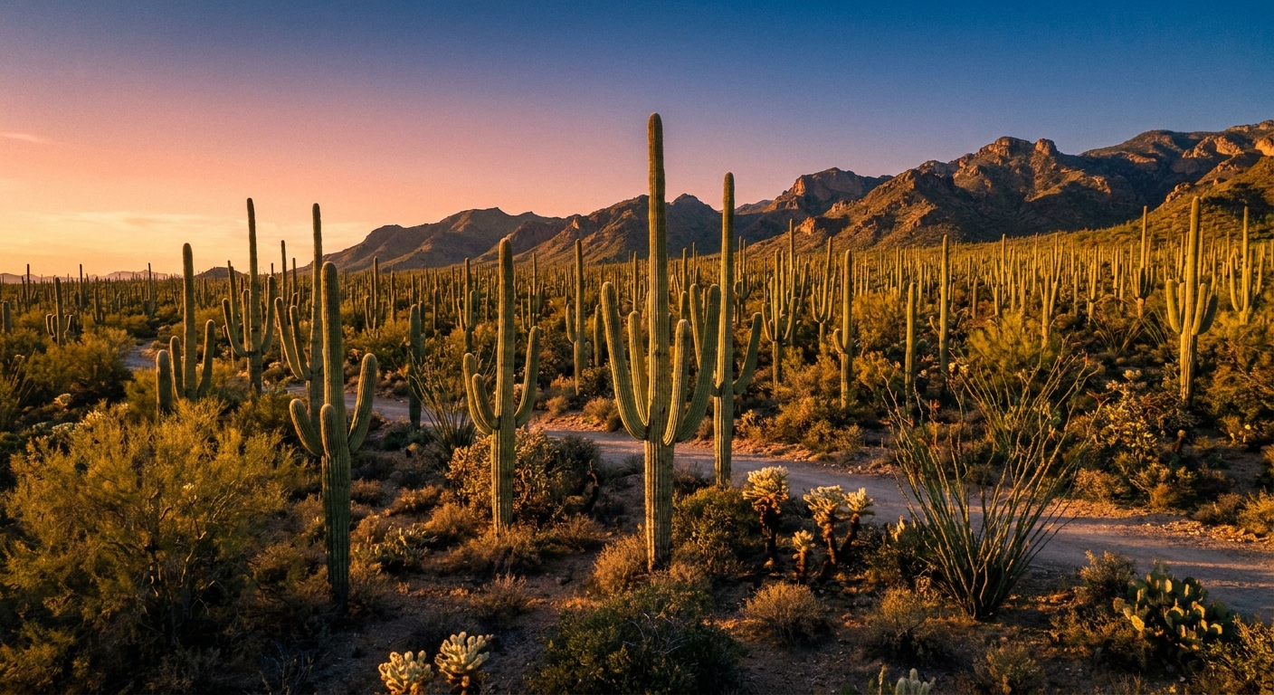
Saguaro National Park is the rare place where you can start your morning in a cactus forest, be back in Tucson for a cold brew by lunch, and still feel like you earned it. The park is split into two districts on either side of the city: Tucson Mountain District (West), known for dense saguaro stands and sunset-friendly viewpoints, and Rincon Mountain District (East), where longer routes climb toward cooler air and big mountain panoramas.
Below are the best hikes in both districts, organized so you can choose a quick leg-stretcher, a classic half-day loop, or a full-on desert workout.

Quick picks
- Best easy sunset walk (West): Valley View Overlook
- Best quick petroglyph stop (West): Signal Hill
- Best easy cactus immersion (East): Freeman Homestead
- Best classic loop (West): Wasson Peak loop (King Canyon, Hugh Norris, Sendero Esperanza)
- Best big-day ridge (East): Tanque Verde Ridge
- Best spring wildflower wander (East): Cactus Forest, with an optional out-and-back spur toward Javelina Wash
Before you hike
Know the basics
- Fees: Entry requires a pass (standard NPS entry fees apply). If you plan to visit more than once, an America the Beautiful pass can be the easiest win.
- Hours: District hours and gate access can vary seasonally. Check the NPS site the night before, especially if you are planning a sunrise start.
- Visitor centers: Great for current trail conditions, heat advisories, and a quick “is this wash sketchy today?” reality check.
- Parking: Popular trailheads and scenic pullouts fill fast on weekends and during peak season. Earlier is easier, and also safer.
Go early, then go earlier
Heat is the main challenge here, not technical terrain. In warm months, plan to start at sunrise. Midday hikes can be risky even on easy trails because there is very little shade.
Carry more water than you think
A common desert baseline in hot conditions is around 1 liter per hour, sometimes more, plus electrolytes. Your needs vary with pace, sun exposure, and acclimation. If you are unsure, bring extra. There is no prize for finishing with an empty bottle.
Wear sun protection you will actually keep on
- Wide-brim hat or cap with neck coverage
- Sunglasses
- UPF shirt or light long sleeves
- Sunscreen you reapply
Know the two-district layout
The park is not one continuous area. “West” and “East” are separated by Tucson. Double-check which district your hike is in before you drive out.
Quick safety and rules
- Pets: Pet rules are strict and trail access is limited. If you are traveling with a dog, confirm what is allowed before you assume any trail is fair game.
- Rattlesnakes: Give them space, watch where you step, and do not put hands where you cannot see.
- Monsoon season: Flash floods can happen even if it is not raining where you are. Avoid washes when storms are in the forecast and be cautious around low crossings.
Best hikes: West
West is the classic “saguaro postcard” side. Trails here tend to be lower elevation, warmer, and packed with cactus density. It is also excellent for short hikes that still feel iconic.
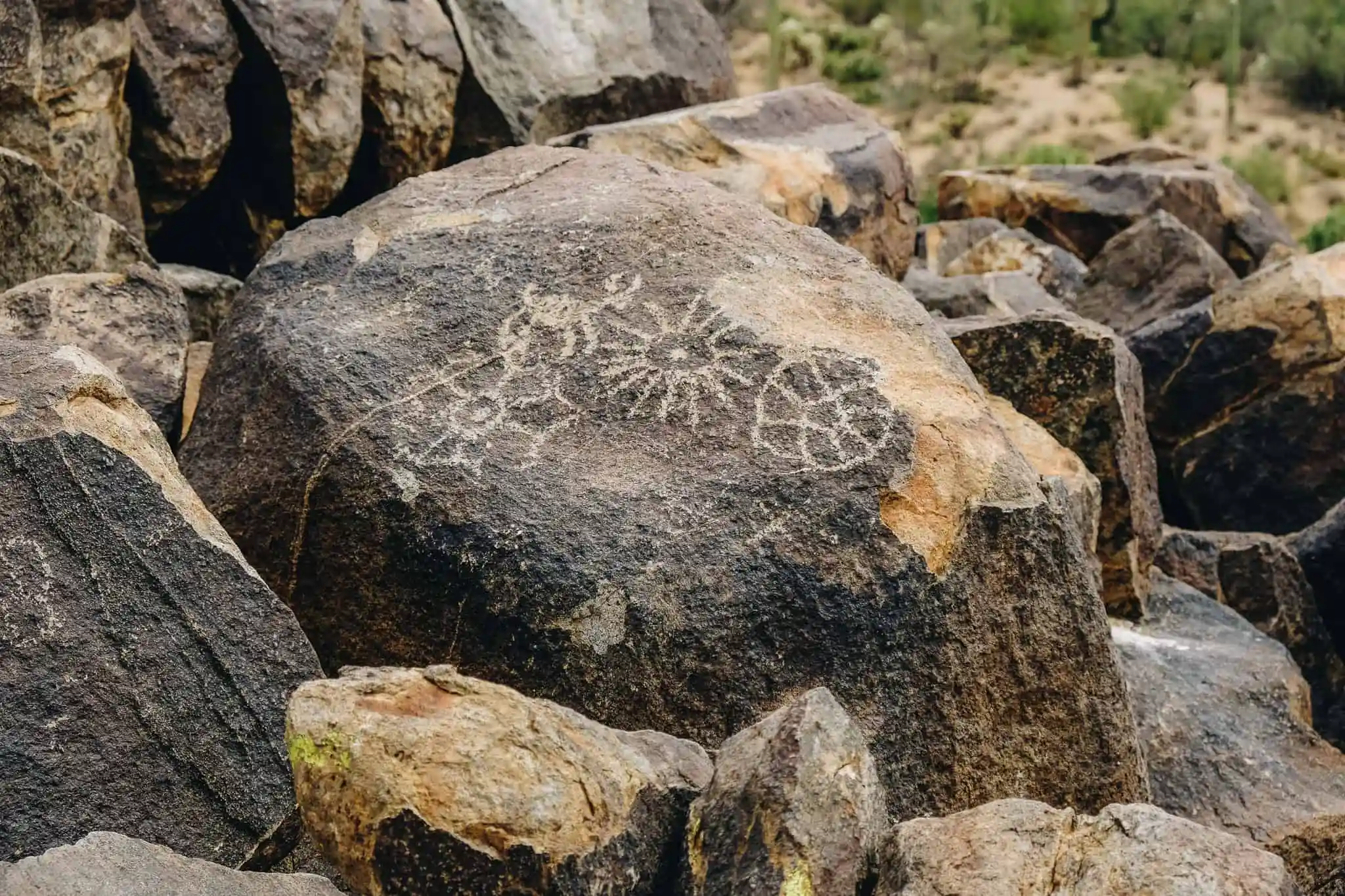
Signal Hill Trail
Why it is worth it: A short walk that delivers fast: sweeping desert views and a concentrated area of petroglyphs. Perfect for a first-time visit or a quick stop when you have less than an hour.
- Distance: about 0.3 miles round trip
- Elevation gain: minimal (short, slightly rocky rise)
- Difficulty: easy
- Typical time: 15 to 30 minutes (longer if you linger)
- Best time: late afternoon for softer light
- Tip: Stay on the trail and view petroglyphs respectfully. Do not touch rock art.
Valley View Overlook Trail
Why it is worth it: Big views for minimal effort. This is the move when you want a scenic payoff without committing to a long hike.
- Distance: about 0.8 miles round trip
- Elevation gain: minimal
- Difficulty: easy
- Typical time: 20 to 40 minutes
- Best time: late afternoon into sunset
- Tip: Bring a headlamp if you are cutting it close to dark. Desert trails get confusing fast once the light drops.
Wasson Peak
Why it is worth it: Wasson Peak is the West district’s signature summit. You get a real climb, wide-open Sonoran Desert views, and that satisfying “I did a thing” feeling without needing ropes or route-finding drama. The main decision is simple: do you want the classic loop, or the straightforward out-and-back?
- Option 1 (classic loop): King Canyon, Hugh Norris, Sendero Esperanza (or the reverse). Why choose it: more variety and a better “tour” of the range.
- Option 2 (out-and-back): Hugh Norris Trail to the summit and back. Why choose it: simple logistics and consistently great views.
- Distance: generally 7 to 10 miles depending on route and connectors
- Elevation gain: roughly 1,800 to 2,500 feet depending on route
- Difficulty: moderate to strenuous, especially with heat
- Typical time: 3 to 6 hours
- Best time: cool months, or very early starts in shoulder seasons
- Tip: Watch your turnaround time. The exposed upper sections heat up quickly.
Best hikes: East
East has a different personality. You still get saguaro-lined trails, but you also get more options to go longer, climb higher, and tap into the Rincon Mountains for a wilder feel.
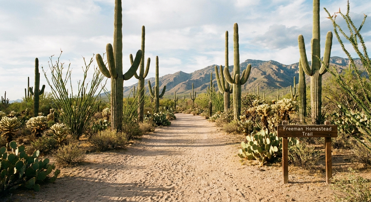
Freeman Homestead Trail
Why it is worth it: A gentle, beginner-friendly loop with classic cactus scenery and interpretive value. Great for families, jet-lag days, or anyone who wants the “Saguaro vibe” without committing to a long hike.
- Distance: about 1 mile loop
- Elevation gain: minimal
- Difficulty: easy
- Typical time: 30 to 60 minutes
- Best time: morning for cooler temps and better wildlife chances
Cactus Forest Trail
Why it is worth it: This is your choose-your-own-adventure hike. You can do a short out-and-back, link it with nearby junctions, or build a longer loop using connecting trails.
- Distance: flexible (popular options are 2 to 6 miles)
- Elevation gain: mostly gentle rollers
- Difficulty: easy to moderate
- Typical time: 1 to 3 hours depending on your route
- Best time: spring mornings for flowers and active wildlife
- Tip: Bring a map or download offline maps. Intersections can feel similar in the cactus forest.
- Wildflower add-on: For a straightforward extension, continue toward a signed wash junction and treat it as an out-and-back spur. If you are not 100 percent sure of the junctions, keep it simple and retrace your steps.
Garwood Dam and Wildhorse Tank
Why it is worth it: A fun, history-tinged hike with a destination feel. The old dam site makes a great turnaround point, and the surrounding desert textures look especially good in soft light.
- Distance: commonly 3 to 5 miles round trip depending on whether you add Wildhorse Tank and which connectors you use
- Elevation gain: moderate
- Difficulty: moderate
- Typical time: 2 to 3.5 hours
- Route note: You can do this as an out-and-back to Garwood Dam, or combine segments into a loop if you are comfortable navigating junctions.
- Best time: late fall through early spring
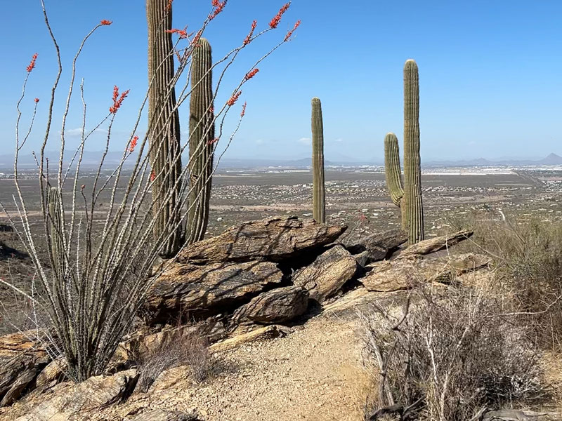
Tanque Verde Ridge Trail
Why it is worth it: If you like big views and do not mind a sustained climb, Tanque Verde Ridge is a standout. Even going partway delivers dramatic overlooks. Going farther turns into an all-day ridge mission.
- Distance: long out-and-back, customizable (many hikers turn around between 4 and 10 miles round trip)
- Elevation gain: significant, even on shorter turnarounds
- Difficulty: strenuous
- Typical time: 3 to 8 hours depending on turnaround
- Best time: cool season with an early start
- Tip: This route is exposed. Plan water carefully and consider trekking poles for the descent.
Douglas Spring to Bridal Wreath Falls
Why it is worth it: When you want the East district to feel like more than a cactus garden, this is a solid step up. You climb into the Rincons, trade some heat for elevation, and (after rain) you might even catch a seasonal waterfall. It is one of the best “bigger hike” payoffs in the district without committing to a full wilderness epic.
- Distance: roughly 5 to 6+ miles round trip depending on turnaround and exact route
- Elevation gain: moderate to significant
- Difficulty: moderate to strenuous
- Typical time: 3 to 5 hours
- Best time: late fall through spring, and especially after recent moisture
- Tip: Do not count on water being present. Treat any flow as a bonus, not a guarantee.
Best hikes by season
Winter
Prime season for longer routes like Wasson Peak or Tanque Verde Ridge. Days are shorter, so start earlier than you think you need to.
Spring
Lower-elevation trails shine, especially in the East district cactus forest. Expect busier weekends when flowers pop.
Summer
Choose short, early hikes only, or consider late-day walks where allowed and safe. Monsoon season can bring sudden storms and lightning risk on exposed ridges. Avoid washes when storms are in the forecast.
Fall
Temperatures start to ease and longer hikes return to the menu. It is one of the best times to combine hiking with a same-day Tucson neighborhood wander.
What to pack
- Water: more than you think, plus electrolytes
- Sun protection: hat, sunglasses, sunscreen, light layers
- Footwear: trail runners or hiking shoes with decent grip
- Navigation: offline maps for longer routes
- Snacks: salty options work well in the heat
- Emergency basics: headlamp, small first-aid kit, blister care
Desert hiking is less about toughness and more about timing. Start early, sip often, and save the long miles for cool weather.
Where to stay in Tucson
One of my favorite things about Saguaro is how easy it is to pair a hike with city comforts. If you are staying in Tucson, choose a base that matches your hiking priorities:
- For West district access: west Tucson or near the Arizona-Sonora Desert Museum area
- For East district access: east Tucson near the Speedway or Broadway corridors, or closer to the Rincon foothills
- For a walkable post-hike evening: Downtown or 4th Avenue for restaurants and cafes
FAQ
Which side is better?
West is best for iconic dense saguaro scenery and quick viewpoint hikes. East is best for longer routes and a wider range of trail options. If you only have one morning, pick the district closest to where you are staying and start early.
Can you hike midday?
In cooler months, yes with smart water and sun management. In hot months, midday hiking can be dangerous. Plan sunrise starts and shorter routes.
Are these hikes beginner-friendly?
Yes, especially Signal Hill, Valley View Overlook, Freeman Homestead, and shorter sections of Cactus Forest Trail. Save Wasson Peak and Tanque Verde Ridge for when you have experience with sustained climbs and heat management.