Oregon Coast Hikes: Cannon Beach to Cape Perpetua
The Oregon Coast is not one long beach day. It is a string of pocket adventures stitched together by Hwy 101, where your best moments often happen in a 45-minute window around low tide, followed by a hot coffee and a warm car seat. This guide gives you two ways to do it: a realistic multi-day north to south plan (best if you are already road-tripping) and a hub and spoke approach (best if you are based in one town and want day stops without packing up every morning).
Three anchors, three totally different moods: Cannon Beach for iconic sea stacks and civilized comforts, Cape Perpetua for mossy forest trails that drop you onto raw basalt coastline, and Samuel H. Boardman Scenic Corridor for jaw-dropping cliff and arch viewpoints. The common thread is tide timing, knowing what can close after storms, and being honest about drive time.

Before you go: tides, closures, and what is realistic
How to use tide tables for sea stacks, arches, and tide pools
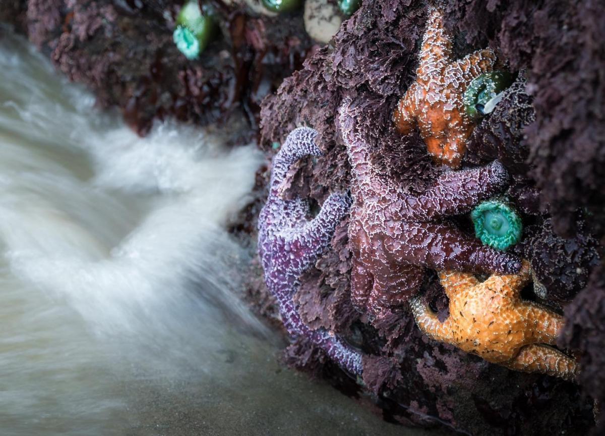
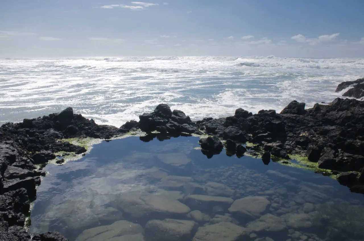
For sea stacks and tide pooling (Cannon Beach around Haystack Rock, and Cape Perpetua at places like Thor’s Well and Devil’s Churn), you will have the best access and safest footing near low tide . For arches and sea caves (especially in the Boardman corridor), lower water often reveals more of the scene and gives you better angles from the trail and viewpoints, even if you are not walking on the beach.
- Target window: plan to be on the coast feature 1 to 2 hours before low tide through 1 hour after.
- Extra caution: if the swell is up, even a low tide can be dangerous on basalt shelves. Never turn your back to the ocean and stay off wet, algae-slick rock.
- Where to check tides: use NOAA station predictions. Practical reference points for this itinerary include Astoria or Seaside for the north coast (Cannon Beach area), Yachats (or the closest available NOAA station to Yachats) for Cape Perpetua, and Brookings if available for the far south coast near Boardman. If your exact stop does not have a NOAA station, use the nearest coastal station as a proxy and keep a wider safety buffer.
Closure and hazard links to bookmark
Oregon’s coast is rugged and dynamic, which is the polite way of saying: winter storms rearrange trails, slides happen, and the state sometimes closes pullouts and sections for repairs. Check these before you commit to a long drive.
- Road conditions (Hwy 101 and connectors): Oregon Department of Transportation TripCheck: https://tripcheck.com/
- State park trail and facility alerts: Oregon State Parks alerts: https://stateparks.oregon.gov/ (open the park page and look for alerts)
- Weather, swell, and marine warnings: National Weather Service coastal forecast: https://www.weather.gov/ (choose your coastal zone)
- Forest routes near Cape Perpetua: Siuslaw National Forest conditions: https://www.fs.usda.gov/siuslaw
Parking reality and crowd strategy
- Go early for Cannon Beach: mid-morning fills quickly, especially on weekends and summer days.
- Boardman pullouts are small: if a turnout is full, keep rolling to the next one rather than squeezing into unsafe shoulder parking.
- Cape Perpetua lots: the main viewpoints can be busy, but trails let you disappear fast. A 10-minute walk often buys you quiet.
Drive time reality
Cannon Beach, Cape Perpetua, and the Boardman corridor do line up nicely from north to south, but they do not behave nicely in one day. Treat the coast like a set of short stages and you will actually enjoy it.
- Cannon Beach to Cape Perpetua (Yachats area): roughly 3.5 to 4.5 hours depending on traffic, stops, and conditions.
- Cape Perpetua (Yachats area) to Boardman (Brookings area): roughly 4.5 to 6 hours depending on traffic, construction, and how many “quick” viewpoints you cannot resist.
Fees and passes (quick heads up)
Some Oregon State Park day-use areas charge a day-use parking fee, and some sites use pay stations rather than staffed kiosks. Bring a card and a backup payment option. Rules can change park to park, so verify the specific stop on Oregon State Parks before you go. If you carry an America the Beautiful pass, treat it as a bonus in federal areas, not a guaranteed cover for state park day-use parking.
Option A: North to south road trip (2 to 4 days)
This is the classic “keep moving south” plan for travelers already on a longer Oregon road trip. The key is simple: one tide-dependent highlight per day, plus short forest connectors and viewpoints that are flexible when weather changes.
Day 1: Cannon Beach
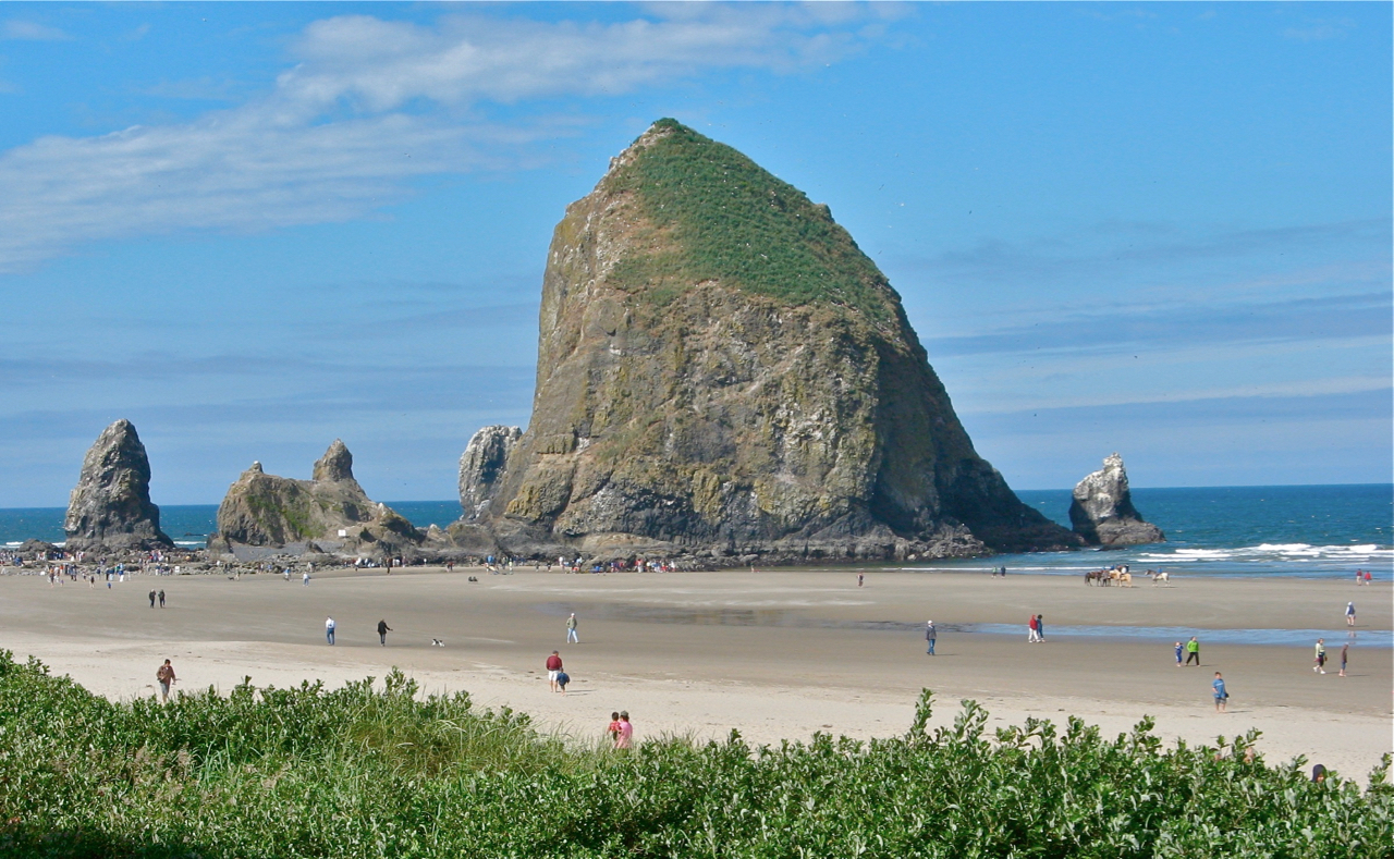
Best for: iconic photos, tide pools, an easy beach walk, and a strong start with coffee and pastries.
- Plan your timing: if low tide is in the morning, start at Haystack Rock. If low tide is later, treat this as a sunrise beach walk and save serious tide pooling for another day.
- What to do: walk the beach toward Haystack Rock and explore exposed rocks only when the tide is safely out.
- Leave time for town: Cannon Beach is one of the easiest places on the coast to pair a hike with comfort. Grab a coffee, then get off the main drag before peak midday parking.
Forest add-on: For that “coast range rainforest” feeling without committing to a long hike, head into Ecola State Park for a short wooded out and back through classic coastal forest (spruce, hemlock, and a lot of green). If you want a named, no-overthinking option: do a short segment of the Clatsop Loop Trail from a convenient trailhead in the park, then turn around when you feel pleasantly mossy.
- How long: 20 to 60 minutes depending on your schedule.
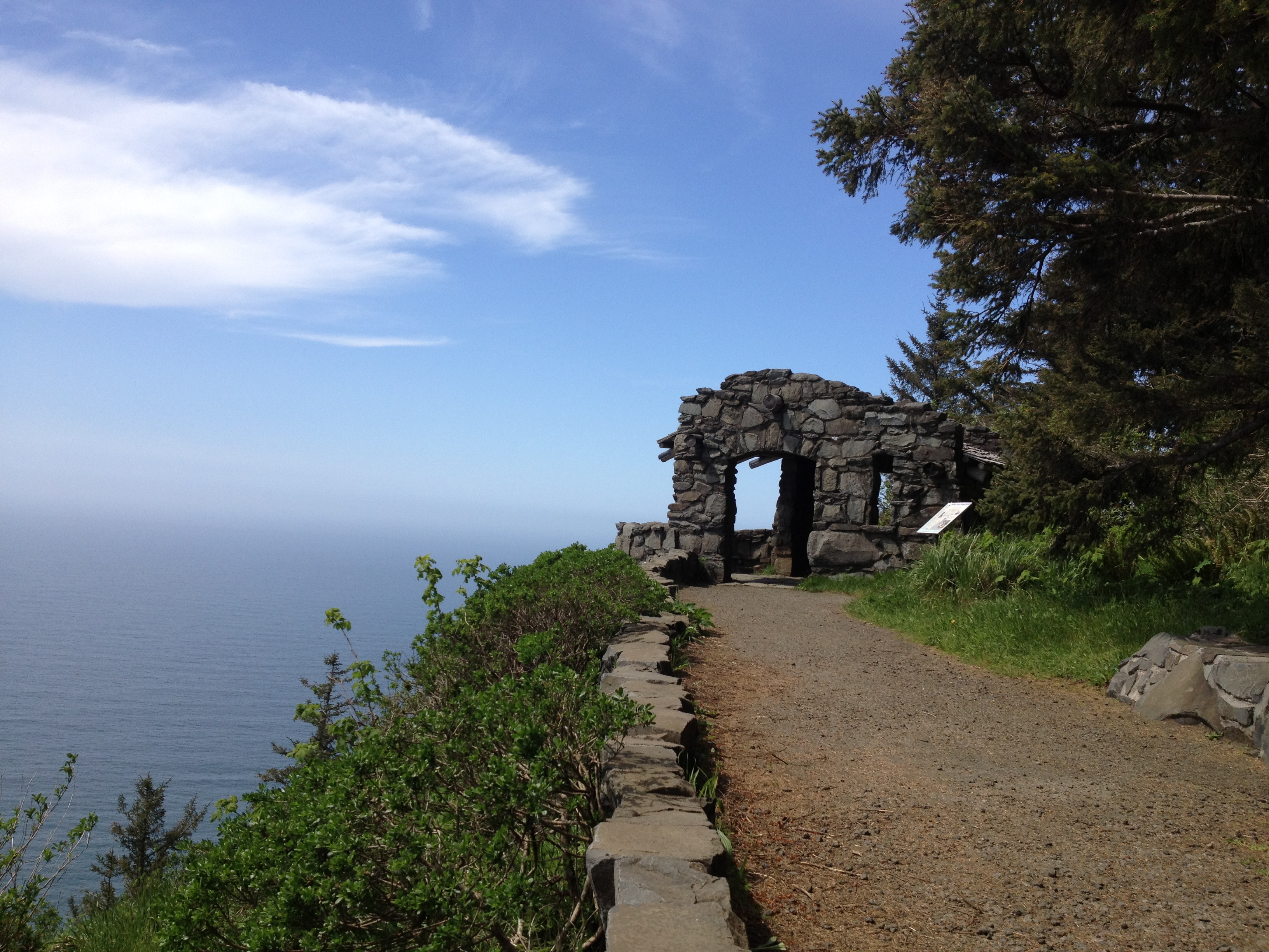
Day 2: Cape Perpetua and Yachats
Best for: basalt drama, wave watching, and short trails with big payoff.
- Thor’s Well: often most dramatic on a rising tide and or with swell, which is also when the area can be most hazardous. Expect spray, keep a wide buffer, and stay back from edges.
- Devil’s Churn: an easy stop with big wave energy in rougher conditions.
- Captain Cook Trail: a short coastal forest walk that adds that ferny, mossy feeling to your day.
Forest add-on: If you want a slightly longer, legs-happy option with a view payoff, consider the Spruce Root Trail (steep in spots, very worth it) or a shorter wander on the Captain Cook Trail if you want to keep it mellow.
Driving note: Cannon Beach to Cape Perpetua is a real drive. Build in slack, plan one main tide stop, and let everything else be optional.
Day 3: Samuel H. Boardman Scenic Corridor
Best for: coastal arches, cliffside viewpoints, and short punchy walks that feel like mini expeditions.
The Boardman corridor is made for day stops. You string together a few iconic viewpoints, each with a short trail, and you keep moving. Pick two to four based on light and energy.
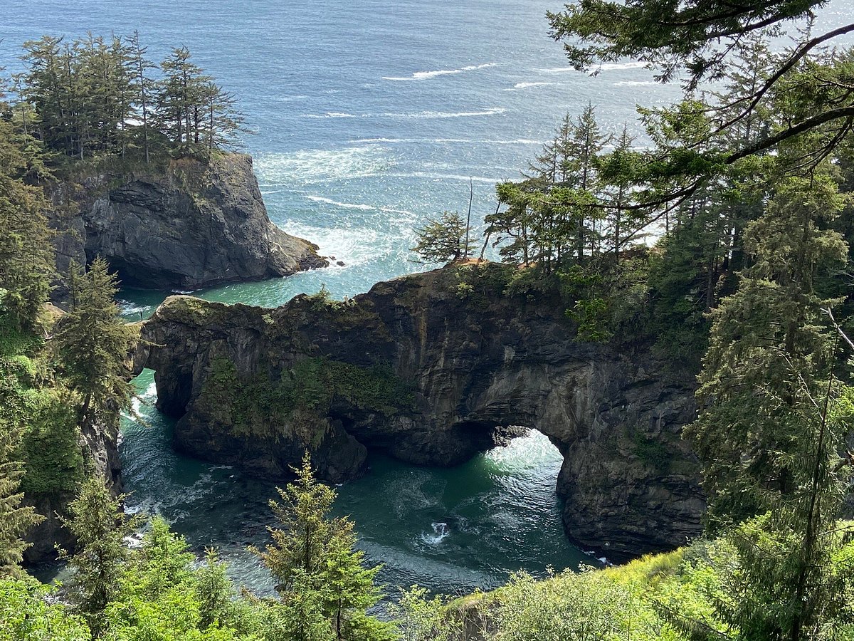
- Natural Bridges: one of the most famous views in the corridor with a short trail to an overlook. Great even if you are not timing it to an extreme low tide.
- Secret Beach: a steep forest path down to a dramatic cove. Only do this if conditions are dry enough for you to feel steady on the climb back up.
- Arch Rock viewpoints: classic rugged coastline and big payoff for minimal mileage.
Timing note: if you can match Boardman to a lower tide, do it, but treat it as a bonus. Your access is mostly viewpoint based, and the scenery is still spectacular at mid tide.
Forest connector: In Boardman, the best connector is simply committing to a slightly longer segment on foot rather than driving every turnout. If you want a specific, easy-to-execute choice, do a longer out and back on the Oregon Coast Trail from one of the signed Boardman trailheads near your chosen viewpoint. You will trade steering wheel time for quiet.
- How long: 45 to 90 minutes.
If you only have one day
Pick one region and do it well. Cannon Beach plus Ecola, or Yachats plus Cape Perpetua, or Brookings plus Boardman. The coast rewards focus.
Option B: Hub and spoke days
If you prefer slow travel and less windshield time, choose one base and do day loops. This is also the best way to work the tide properly, because you can match your big tide pooling session to the correct day and time.
Base near Cannon Beach (north coast)
- Best for: easy beach access, great food, art galleries, and short hikes that still feel wild.
- Ideal day: morning low tide at Haystack Rock, midday forest trail in Ecola, sunset beach walk with a warm drink.
Base near Brookings or Gold Beach (south coast for Boardman)
- Best for: maximizing Samuel H. Boardman without rushing, plus extra time to wait out fog for those clean headland views.
- Ideal day: start early at one major viewpoint, do one beach descent (only if conditions are dry and you are steady on steep trails), then finish with a longer coastal trail segment through the trees.
Base near Yachats (central coast for Cape Perpetua)
- Best for: Cape Perpetua plus cozy town comforts and excellent post-hike food.
- Ideal day: tide timed Thor’s Well and Devil’s Churn from safe edges, then an inland forest hike to shake out your legs and get away from the viewpoint crowds.
Tide-first mini itineraries
Use these as building blocks inside Option A or Option B. The order below keeps geography sane and driving realistic.
North coast day (Cannon Beach)
- Early low tide: Haystack Rock tide pools, then coffee and a town wander.
- Midday: Ecola forest connector (Clatsop Loop Trail segment works nicely) for a canopy reset.
- Late day: sunset beach walk when the crowds thin and the light softens.
Central coast day (Cape Perpetua)
- Tide and swell window: Thor’s Well and Devil’s Churn from safe edges. If the swell is up, treat this as a viewpoint-only session and keep your distance.
- Midday: Captain Cook Trail for moss, ferns, and quiet.
- Late day: refuel in Yachats and pick a mellow viewpoint for last light.
South coast day (Boardman)
- Morning: start at a major viewpoint while the air is clear and your legs are fresh.
- Midday: choose two to four stops (Natural Bridges, Arch Rock viewpoints).
- Low tide bonus: if conditions are calm and the tide is friendly, add a beach descent like Secret Beach only if the trail is dry enough for a safe climb back up.
- Afternoon: do one longer Oregon Coast Trail segment to replace pullout hopping with actual walking.
One-way southbound stage (Cannon Beach to Cape Perpetua)
- Morning: Cannon Beach beach walk and coffee.
- Midday: drive south and keep stops short and intentional.
- Afternoon into evening: Cape Perpetua for your main tide window and moody light.
- Backup: if swell is high, skip basalt edges and stick to higher viewpoints and forest trails.
Season and conditions notes
- Summer: longest days and friendlier trail conditions, plus the most parking pressure. Start early and plan your tide stop like a reservation.
- Shoulder season (spring and fall): fewer crowds, moodier light, and more mixed weather. This is prime “cozy town after wild coastline” season.
- Winter: spectacular storm watching, but also the highest odds of closures, downed trees, and hazardous surf. This is also peak time to take sneaker wave warnings seriously. If you are not sure, watch from higher ground and call it a win.
- Fog: common in summer, especially mornings. Instead of fighting it, pivot to forest trails first and come back to viewpoints when it lifts.
Gear and safety notes I follow on the Oregon Coast
- Footwear: grippy trail runners or hiking shoes. Basalt plus algae turns slick fast.
- Layers: a light rain shell and a warm mid-layer even in summer. Coastal wind has opinions.
- Carry-on only mindset: keep a small day bag stocked with a headlamp, snacks, and a dry layer so you can take detours without repacking.
- Leave no trace at tide pools: look, do not touch. Step on bare rock, not living organisms.
- Swell awareness: if you hear a roar change or see the waterline surge unexpectedly, move up immediately.
Where to refuel
This is my favorite part of coast travel: rugged morning, cozy afternoon. Oregon’s coastal towns are built for it.
- Cannon Beach: grab coffee and a pastry before you get sandy, then come back for a warm meal after your beach time.
- Brookings or Gold Beach: treat these as your practical bases for Boardman, with groceries and hot food that make short hikes feel like a real itinerary.
- Yachats: perfect for post Cape Perpetua comfort, especially when you want to thaw out after wind and spray.
Quick planning checklist
- Check NOAA tides for the nearest station to your main tide-dependent stop (Astoria or Seaside for Cannon Beach, Yachats area for Cape Perpetua, Brookings if available for Boardman).
- Check TripCheck for Hwy 101 issues and delays: https://tripcheck.com/
- Check Oregon State Parks alerts for closures and day-use details: https://stateparks.oregon.gov/
- Pick one: tide pools or basalt features as the day’s must-do, then let the rest be flexible viewpoints and forest connectors.
- Build in slack. On the Oregon Coast, the best scenes often show up five minutes after you stop trying to optimize everything.