White Pocket Arizona: Road Conditions, 4x4 Access, and Photo Safety
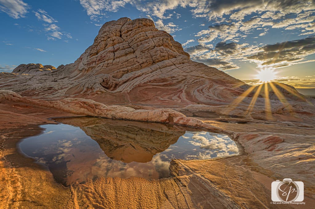
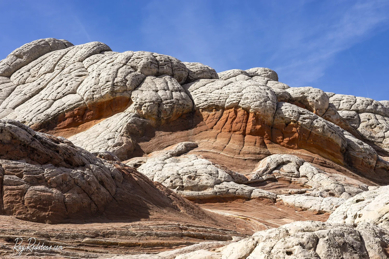
White Pocket is the kind of place that makes you feel like you accidentally walked onto another planet, all swirls of white sandstone, butterscotch bands, and little pockets that catch the light like porcelain. It is also the kind of place where a normal rental car can turn your dreamy photo day into an expensive recovery situation.
This page is here to set expectations. Not just the pretty part, but the BLM road reality, the sand, the lack of cell service, and the small choices that keep the area wild for the next traveler.

Where it is
White Pocket sits in the Vermilion Cliffs area of northern Arizona on the Paria Plateau, not far from the Utah border. Most travelers approach from the US-89 corridor between Kanab and Page, then transition onto BLM roads for the final stretch.
It is on public land managed by the Bureau of Land Management (BLM), but it is not a paved, signed, easy pull-off kind of destination. The final approach is a network of sandy roads where conditions can change quickly with wind, recent traffic, or a single storm.
There are typically no services at the site. No water. No toilets. No trash cans. Your planning is the safety net. For supplies and last-minute fixes, the nearest full services are usually in Kanab or Page.
How to get there
This is the piece most people wish they had in plain English: the access is straightforward in concept, but easy to mess up in practice because map apps can route you into rougher roads, private property edges, or slow sand washes that look “fine” until they are not.
Main access roads to know
- House Rock Valley Road (also signed in places as BLM 1065): a common north to south gravel access road off US-89 in the Vermilion Cliffs area.
- BLM 1017 and BLM 1087: commonly referenced BLM roads used on the approach toward White Pocket once you are off the main gravel corridor.
Road names and signage can vary, and conditions change. Treat these road names as orientation help, not a promise of an easy drive. Before you go, confirm your exact route with an up-to-date source (local outfitter, shuttle operator, or recent trip reports), then download offline maps .
Drive time reality
From Kanab or Page, many visitors budget roughly 2.5 to 4.5 hours one way depending on route choice, sand depth, washboard, and weather. The road is the time thief. Build in margin.
Road conditions
Expect deep sand
Most people think “high clearance” means rock steps and sharp ledges. At White Pocket, the bigger problem is often sand. Deep, loose sand that behaves differently depending on temperature, wind, and how churned up it is from prior vehicles. You can have a perfectly dry forecast and still get stuck.
Ruts, washboard, and soft spots
Even when the sand is manageable, the road can be heavily washboarded, which is hard on tires and suspension and makes travel slower than you expect. Ruts can pull a vehicle off line. Soft shoulders can collapse under a tire. If you have not driven sand before, the learning curve is real.
Mud and clay after storms
Not every approach is identical, and conditions vary by route. Some sections are sandy, some can turn clay-like and slick after precipitation. Rain and snow turn “challenging but doable” into “do not attempt.” Low spots can hold water. What looks like a shallow puddle can hide deep mud. If there is recent precipitation in the area, wait it out or go with a local guide who knows what the road has been doing that week.
If your plan depends on arriving exactly at sunset, build in extra time. The road may force you to drive much slower than your map suggests.
Do you need 4x4?
For most visitors, yes. High-clearance 4x4 is the smart baseline because it gives you margin. Margin is what keeps a bad decision from becoming an emergency.
4x4 is recommended if
- You are visiting for the first time and want a low-stress day.
- You have not driven in deep sand before.
- You are traveling solo or without another vehicle.
- You are going in shoulder season when weather can swing fast.
- You want to stay for golden hour and drive out in fading light.
Even with 4x4, know what matters
- Tires: All-terrain tires help. Worn street tires do not.
- Air pressure: Many sand drivers “air down,” meaning you lower tire pressure to help the tires float and grip in soft sand. If you air down, you also need a way to reinflate, like a portable compressor, and you need to know safe pressure ranges for your vehicle.
- Recovery gear: A shovel and traction boards can be the difference between “ten minutes and we are moving” and “hours of digging.”
And a reality check: AWD is not the same as true 4x4 in sand. Some AWD systems overheat or struggle in sustained deep sand, especially with low ground clearance.
Shuttles and guides
I love independence as much as anyone, but White Pocket is one of those places where paying for local expertise can be the most budget-friendly decision you make all day. A reputable guide or shuttle does three things: reduces your risk of getting stuck, removes a huge chunk of navigation stress, and helps you arrive with energy to explore instead of white-knuckle driving fatigue.
Hire a shuttle or guide if
- You are in a standard rental car or low-clearance SUV.
- You are traveling with kids, older family members, or anyone who would not do well with a long delay in the heat.
- You are visiting in winter, monsoon season, or during unpredictable weather.
- You want to photograph sunrise or sunset and do not want to drive sand in the dark.
- You do not have recovery gear and do not want to build a sand-driving skillset on this road.
Guides also add value on the ground. White Pocket is open exploration, not a single signed trail. A good guide will point out fragile areas to avoid, safer lines for climbing, and great compositions without trampling the most delicate features.
Navigation and signal
Plan as if you will have no signal. Download offline maps before you leave town and bring a second navigation option. Also, be aware that map apps sometimes pick the “shortest” line that is not the safest line.
At minimum, have:
- Offline maps downloaded to your phone.
- A dedicated GPS unit or a second phone with offline maps as backup.
- A fully charged power bank and a car charger.
Also, tell someone where you are going and when you expect to be back in service. It feels old-school, but it is the desert version of seatbelts.
If you want to level up your safety, a satellite messenger is a smart add for this area.
What to pack
Footwear
White Pocket is mostly rock, but it is not sidewalk-flat. You will be stepping over fins, pockets, and small ledges, sometimes on sand-dusted stone that can be slick. Leave the smooth-soled fashion sneakers for Page, the nearby hub town a lot of people use as a base.
- Best choice: trail runners or light hiking shoes with good tread.
- Nice to have: ankle coverage if you are prone to rolling ankles on uneven surfaces.
- Avoid: slick soles, flimsy sandals, or anything you would hate to get gritty sand inside.
Water
There is no reliable water out here, and the sun can surprise you even in cooler months. A safe, simple baseline is:
- At least 3 liters per person for a half-day visit.
- Closer to 4 to 6 liters per person if it is hot, you are staying for long photo sessions, or you tend to drink a lot while hiking.
Add electrolytes. Desert dehydration is not just about thirst, it is about keeping your body functioning when you are baking on reflective rock.
Also keep extra emergency water in the vehicle beyond what you plan to carry while exploring. Getting stuck turns a “short outing” into a longer one fast.
Other essentials
- Sun protection: hat, sunglasses, sunscreen.
- Layers: mornings and evenings can be cold, even when midday is warm.
- First aid basics plus blister care.
- Headlamp if you might be out near sunset.
- Trash bag: pack out everything, including food scraps.
- Tire compressor if you plan to air down.
If you get stuck
It happens, even to experienced drivers. The key is keeping a bad moment from turning into a dangerous one.
- Stay with your vehicle. It is your shade, your shelter, and the easiest thing for others to spot.
- Do the simple recovery steps first: stop spinning tires, shovel sand away from the tires, air down if you know how, use traction boards, then try a gentle, steady pull.
- Do not “road braid.” Avoid driving off established tracks to hunt for firmer ground. That damages fragile terrain and creates new scars that encourage more vehicles to spread out.
- Call for help if you have it. This is where a satellite messenger earns its keep.
Leave No Trace
White Pocket’s beauty is also its vulnerability. That pale sandstone and the dark crusty patches you will see in places are not “just dirt.” Much of that dark, textured surface is biological soil crust (often called cryptobiotic soil crust), a living community that helps hold desert soils together and can take decades to recover from a single footprint.
Stick to durable surfaces
Whenever possible, travel on slickrock and bare stone. Step on sand in washes rather than on darker crusty areas. If you are unsure, assume the darker, textured surface is fragile.
Do not improve photo spots
Resist the urge to move rocks, build cairns, or clear sand from pockets to make patterns pop. The best photo is the one that does not change the place.
Pack it all out
Yes, even orange peels and sunflower seed shells. In a dry ecosystem, food waste lingers and changes animal behavior.
Have a human waste plan
There are no toilets. Carry a wag bag or a human waste pack-out system and use it. It is the standard for fragile desert destinations and it keeps the area from becoming an open-air latrine as visitation grows.
Respect signs and closures
If you see closure signs or restoration areas, take them seriously. They exist because the landscape is trying to heal, and it needs our help.
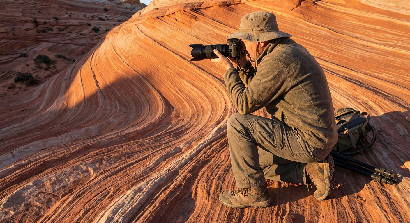
Photo safety
White Pocket looks like a playground, but it is still wild rock in a remote place. Small mistakes get bigger when you are far from help.
Watch your footing
A thin layer of sand on smooth sandstone can be surprisingly slippery. Move slowly, especially when stepping down off rounded edges.
Skip the one-more-step shot
The best compositions often tempt you toward the edge of a fin or a drop. If you would not do it without a camera in your hands, do not do it with one. Set your tripod or your stance on a stable platform first, then compose.
Drone use
Rules can change, and boundaries can be confusing in the Vermilion Cliffs region. Before flying, verify current regulations for the specific spot you are in (BLM office guidance is the safest source), and always fly in a way that does not disturb other visitors or wildlife .
Protect your gear from sand
- Bring a small blower or soft brush for lenses.
- Change lenses only when you are sheltered from the wind.
- Use a bag that zips fully closed.
White Pocket vs The Wave
This is where a lot of travelers get pleasantly surprised. White Pocket delivers that sculpted, surreal Vermilion Cliffs aesthetic without the same permit stress as The Wave.
The Wave
- Permit required: yes, via a competitive lottery system (Coyote Buttes North).
- Strict daily limit: yes.
- Experience: iconic, defined route to a specific formation, heavy planning required.
White Pocket
- Permit: typically no Coyote Buttes permit is required for White Pocket, and there is no Wave-style lottery. Rules can change, so confirm current requirements before you go.
- Access challenge: the road is the main barrier, not the permit system.
- Experience: open exploration across a broader area of formations with fewer “stand here” moments.
Think of it this way: The Wave is a single headline act. White Pocket is a whole album, and you can wander through tracks at your own pace.
Best time to go
For comfort
Spring and fall are usually the sweet spot for temperatures. Summer can be brutally hot. Winter can bring snow, ice, and short daylight that compresses your whole plan.
For light
Sunrise and late afternoon are magic on the swirls and curves. Midday is harsher, but it can still work if you lean into contrast and patterns, or focus on close-up details where shadows create texture.
For road stability
Dry periods are generally easier than immediately after storms. Monsoon season (often mid to late summer) can change road conditions quickly. Wind can move sand around, so even a dry forecast does not guarantee firm tracks. When in doubt, ask a local outfitter or shuttle operator what the road has been like recently.
Quick checklist
- Do you have true high-clearance 4x4, or are you planning to shuttle?
- Do you know your approach roads (House Rock Valley Road and the BLM spurs) and have offline maps?
- Do you have offline navigation and a backup plan?
- Do you have at least 3 liters of water per person, plus electrolytes and extra emergency water in the vehicle?
- Do you have sun protection, layers, and a headlamp?
- If airing down, do you have a way to reinflate?
- Do you have a plan for trash and human waste pack-out?
- Did you check recent weather and avoid the day after heavy rain or snow?
- Did you tell someone your route and return time?
If that list feels like a lot, it is. But that is also what makes White Pocket special. It is not designed for crowds. It rewards the travelers who show up prepared, move gently, and leave the sandstone exactly as they found it.